• COVID-19 Park and Trail Closures
  • Learn about the Six-Pack of Peaks Challenge
  • Shop
  •  

SoCal Hiker

  • Find a Hiking Trail
    • All Areas
    • Arizona
    • Colorado
    • Los Angeles
    • Orange County
    • Oregon
    • San Francisco Bay
    • Washington
  • Trail Guides
  • Six-Pack of Peaks
    • Colorado Six-Pack of Peaks
      • Bergen Peak
      • Rocky Mountain
      • Birthday Peak
      • Horseshoe Mountain
      • Grays Peak
    • New England Six-Pack of Peaks
    • NorCal Six-Pack of Peaks
      • Mount Umunhum
      • Mount Saint Helena
      • Mount Tamalpais
      • Mount Diablo
      • Mount Sizer
      • Rose Peak
    • Oregon Six-Pack of Peaks
      • Tumalo Mountain
      • Black Butte
      • Black Crater
      • Maiden Peak
      • Mount Bachelor
      • South Sister
    • SoCal Six-Pack of Peaks
      • Mt. Wilson
      • Cucamonga Peak
      • Mt. San Antonio (Mt Baldy)
      • San Bernardino Peak
      • San Jacinto Peak
      • San Gorgonio
  • Backpacking
    • High Sierra Trail
    • John Muir Trail
      • Overview of the John Muir Trail
      • Training
      • Day-by-Day Itinerary
      • Resupply Addresses
      • JMT Discussion Forum
    • Lost Coast Trail
    • North/South Lake Loop
    • Rae Lakes Loop
    • Red Peak Pass Loop
    • Theodore Solomons Trail
    • Trans-Catalina Trail
    • Wonderland Trail
  • Gear
  • Forums
    • Latest Topics
    • Ask a Question
    • Campfire
    • Trails
    • Trail Reports
    • Gear Wisdom
    • Classifieds
  • Login

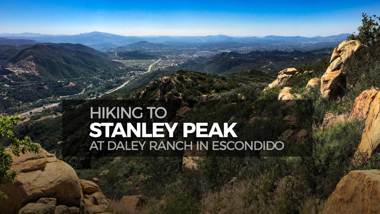
Hike to Stanley Peak in Daley Ranch

May 23, 2018 By Jeff Hester 4 Comments

Hike to Stanley Peak at Daley Ranch in Escondido

Everyone needs a peak in their backyard, and 1,975′ Stanley Peak in Escondido’s Daley Ranch makes a great go-to hike that you can finish before lunch. This loop route gives you a fine overview of historic Daley Ranch, with sweeping views over much of north San Diego County.

Trail Details
Summit: 1,975′ 
Distance: 6.4 miles
Time: 3-4 hours
Difficulty: Moderate
Elevation gain: 890 ft
Dogs: Yes
When to go: Year-round
The trail itself has very little shade, so it’s best to hike this early in the day and avoid those hot summer days altogether. And of course, wear a hat.

Getting to the Trailhead

Daley Ranch can be reached at 3024 La Honda Drive, Escondido, CA 92027. The unpaved parking lot for Daley Ranch gets crowded on the weekends and people end up parking down the hill. It’s best to get there early to avoid the head of mid-day and the worst of the crowds.

Daley Ranch parking
Rules at Daley Ranch
Rules of Daley Ranch
Daley Ranch trailhead

The park is open from dawn to dusk. Dogs are allowed on leash, though the trails can get hot in the afternoon. The historic Daley Ranch House (which is on this loop) is open the second Sunday of the month from 11am to 2pm. For the latest park info, call 760-839-4680.

Hiking to Stanley Peak

There are 20 miles of trails in Daley Ranch, and a number of routes that you could take to get to the summit. We stitched together this loop with a short out-and-back segment to Stanley Peak, and passing by Mallard Lake and the old Daley Ranch House.

This counter-clockwise loop begins at the entrance to Daley Ranch, and follows the Creek Crossing Trail east for about 0.7 miles. This is a broad, dusty double-track that is shared by mountain bikes, horses and hikers. Creek Crossing ends at the East Ridge Trail. Turn right here (southeast) and hike roughly 300 yards to where it ends at the Sage Trail. Turn left (northeast).

Our hiking crew in Daley Ranch

You’ll stay on the dusty Sage Trail as it winds its way through the rolling, rocky hills. Continue past the junction with the Caballo Trail, Quail Run, Coyote Run and the Old Tank spur.

On the Sage Trail in Daley Ranch

As the Sage Trail climbs, the views begin to open up.

Junction with Quail Run Trail
Derek from 100Peaks and Burger Bench
Derek from 100 Peaks and Burger Bench
Views of Escondido from the Sage Trail
Josh from California Through My Lens

Finally, when you reach the spur trail to Stanley Peak, turn right and follow it to the summit — roughly 0.7 miles each way. The trail starts with a fairly flat section.

The Stanley Peak Trail in Daley Ranch

Soon you climb higher, with a great view of the rusted Old Water Tank and the valley below.

Looking down at the Old Tank in Daley Ranch

At the summit, there are boulders to scramble on. If you’re lucky, you might find a scrap of shade to protect you from the sun. And there are the views. Looking east you can see Palomar Mountain, and south the city of Escondido.

View east from Stanley Peak in Daley Ranch
View east
View toward Escondido from Stanley Peak in Daley Ranch
Looking south towards Escondido
Alyx from Shoestring Adventures
Alyx of Shoestring Adventures

After soaking in the views, refueling with snacks and water, head back down the spur trail.

A rare patch of shade on the Sage Trail in Daley Ranch

When you rejoin the Sage Trail, bear to the right (west). This will take you past idyllic Mallard Lake.

Idyllic Mallard Lake along the Sage Trail in Daley Ranch

Continue on Sage toward the old Ranch House, joining the Ranch House Trail – a smooth dirt road that sees occasional use from park vehicles. You’ll pass right through many of the historic buildings from the Daley Ranch.

On the Ranch House Road in Daley Ranch

In the ranch complex, there are restrooms, picnic tables and perhaps best of all on a hot, sunny day, ample shade trees.

From the ranch house, it’s under a mile of easy hiking back to the trailhead to finish the loop.

Stanley Peak Trail Map & Elevation Profile

© OpenStreetMap contributors
Download

When in Escondido, eat at Burger BenchLocal Tips

  • Did I mention that there’s a lot of sun exposure on this hike? Bring a hat, sunscreen and plenty of water. Start hiking before the worst heat of the day, and avoid altogether on really hot days.
  • After the hike, head to Burger Bench in quaint downtown Escondido. Awesome burgers and local craft beers on tap, and the owner also happens to be a hiking blogger. Tell Derek that SoCalHiker sent you! 

Related Resources

  • Official Daley Ranch website
  • Printable map of the Daley Ranch trail system (PDF)
  • Afoot and Afield: San Diego County – A classic guidebook updated by Scott Turner
  • Stanley Peak – 100peaks.com
  • Daley Ranch’s Stanley Peak Hike – Campfire Kam

Daley Ranch Weather Forecast

The location could not be found.

Originally hiked on February 27, 2016. Thanks to Joan, Alyx, Josh, Christopher, Kam, Derek, Traci, Paul, Yoko, Mark, Bev, and Amy for joining me on this hike. 

Related

Filed Under: Trail Guides Tagged With: 6-8 miles, Daley Ranch, dog-friendly, moderate, peakbagging, San Diego County

Like what you found here at SoCal Hiker? This site is a labor of love. Share your support for the site and help us development of new trail guides and expanded coverage -- make your next outdoor equipment purchase through our advertisers.

You can also subscribe to our weekly newsletter and follow us on Facebook or Twitter.

Jeff H

About Jeff Hester

I'm an avid hiker and backpacker. My wife Joan and I are on the trails every weekend. I started SoCal Hiker to share my passion for outdoor adventure.

Comments

  1. Christian says

    May 24, 2018 at 10:09 pm

    This is great! I’m going to try and hike Stanley Peak this weekend. Awesome tips 🙂

    Reply
  2. patricia borchmann says

    May 28, 2018 at 12:56 pm

    Even tho hiking to/from Stanley Peak from Daley Ranch is beyond my own limits, I’m grateful to view the Facebook photos taken from those who did ! Gorgeous views, scenery. Needs more oak trees.
    During rainy season, take seedlings to plant while hiking?

    Reply
  3. jim says

    June 3, 2018 at 2:48 pm

    Thanks will do it next week

    Reply
  4. Madonna Grill says

    August 4, 2018 at 4:10 am

    We set off up the trail, which immediately began to ascend. A large grove of eucalyptus trees grew to the left, but the trail was completely unshaded. The heat wasn’t too bad yet as we’d gotten a reasonably early start, but I knew I would soon be reminded of why I prefer hitting Daley Ranch in the winter.

    Reply

Leave a Reply Cancel reply

Your email address will not be published. Required fields are marked *

This site uses Akismet to reduce spam. Learn how your comment data is processed.

About Jeff Hester

I created SoCal Hiker while preparing to thru-hike the John Muir Trail. My goal? Create guides for the best hiking trails throughout Southern California--and occasionally beyond. I personally hike each trail to create these guides, sharing practical advice on gear and outdoor skills. Read more...

Connect with SoCal Hiker

  • 22,109 Fans
  • 11,612 Followers
  • 21,640 Followers
  • 1,674 Followers
  • 5,420 Subscribers
  • 328 Subscribers

Get the SoCal Hiker Newsletter

Sign up to get your weekly trail recommendation and the latest updates from SoCal Hiker.

SoCalHiker was selected one of USA TODAY's 10 Best Hiking and Outdoor Blogs
Get our day-by-day guide to thru-hiking the John Muir Trail
Get up-to-day wildfire status throughout California

Products

  • Cucamonga Peak mug Cucamonga Peak Mug $15.95
  • Mount Wilson Benchmark Mount Wilson Benchmark $39.95
  • Mt Whitney Replica Benchmark Mt Whitney Benchmark $39.95
  • Mount Wilson T-Shirt $23.00 – $27.00

Sponsors

Sponsor SoCalHiker and see your banner here

Featured Posts

Hiking Camelback Mountain via the Echo Canyon Trail

Camelback Mountain is the most popular mountain to hike in the Phoenix area for good … [Read More...]

Hiking to High Point on Palomar Mountain in the Cleveland National Forest

Appropriately named High Point is the highest peak in the Palomar Ranger District of … [Read More...]

Hiking Hot Springs Mountain on the Los Coyotes Reservation

Hot Springs Mountain in the Los Coyotes Reservation is the highest peak in San Diego … [Read More...]

Lastest Comments

  • Ramesh on Haskell Canyon Open Space
  • Jeff H on Hiking the Tumalo Falls Loop
  • GGreco on Hiking the Tumalo Falls Loop
  • Allan Hoskins on Kintla Lake Hike in Glacier National Park
  • Elizabeth Dawson on Rae Lakes Loop via Kearsarge Pass
Get your SoCalHiker stickers now

Get your SoCalHiker stickers!

Latest Posts

  • Hiking Camelback Mountain via the Echo Canyon Trail December 9, 2020
  • Hiking to High Point on Palomar Mountain in the Cleveland National Forest December 4, 2020
  • Hiking Hot Springs Mountain on the Los Coyotes Reservation November 19, 2020
  • New Day Hiking Permit Requirements for Wilderness Areas in the San Bernardino National Forest August 31, 2020
  • Interview: John Soares, author of ‘Camp for Free: Dispersed Camping & Boondocking on America’s Public Lands’ July 30, 2020

Recent Forum Topics

  • 1st overnight backing trip
  • Recommendations for trips for me and my dog
  • log hikes
  • My Baldy
  • Cactus to Clouds v. Iron Mountain

The Six-Pack of Peaks Challenge Series

Six-Pack of Peaks Challenge SeriesThe Six-Pack of Peaks Challenge gives you an opportunity to explore your world while supporting a great cause.

Flex your adventure muscles!

Learn more here.


Search

Tags

3-6 miles 6-8 miles 8-10 miles 11+ miles Arizona Backpacking coastal dog-friendly easy family-friendly High Sierra Trail hiking Hiking The John Muir Trail hipster inspiration JMT John Muir John Muir Trail Kings Canyon National Park LA County moderate Mount Rainier National Park Muir Monday National Forest National Park Orange County Oregon out of bounds Pacific Crest Trail peak peakbagging quote scenic Sierra Nevada Six-Pack of Peaks State Park strenuous Thru-hiking Utah vista Washington waterfall wilderness Wonderland Trail Yosemite

Copyright © 2021 SoCalHiker.net · Metro Theme on Genesis Framework with WPEngine Hosting · Contact SoCal Hiker · Sitemap · Privacy Policy

Copyright © 2021 · Metro Pro Theme on Genesis Framework · WordPress · Log in