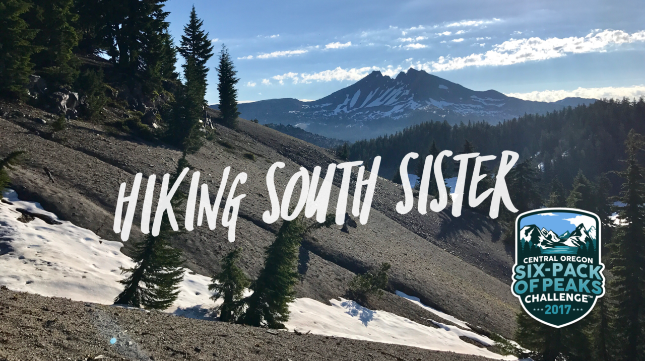
• COVID-19 Park and Trail Closures
  • Learn about the Six-Pack of Peaks Challenge
  • Shop
  •  

SoCal Hiker

  • Find a Hiking Trail
    • All Areas
    • Arizona
    • Colorado
    • Los Angeles
    • Orange County
    • Oregon
    • San Francisco Bay
    • Washington
  • Trail Guides
  • Six-Pack of Peaks
    • Colorado Six-Pack of Peaks
      • Bergen Peak
      • Rocky Mountain
      • Birthday Peak
      • Horseshoe Mountain
      • Grays Peak
    • New England Six-Pack of Peaks
    • NorCal Six-Pack of Peaks
      • Mount Umunhum
      • Mount Saint Helena
      • Mount Tamalpais
      • Mount Diablo
      • Mount Sizer
      • Rose Peak
    • Oregon Six-Pack of Peaks
      • Tumalo Mountain
      • Black Butte
      • Black Crater
      • Maiden Peak
      • Mount Bachelor
      • South Sister
    • SoCal Six-Pack of Peaks
      • Mt. Wilson
      • Cucamonga Peak
      • Mt. San Antonio (Mt Baldy)
      • San Bernardino Peak
      • San Jacinto Peak
      • San Gorgonio
  • Backpacking
    • High Sierra Trail
    • John Muir Trail
      • Overview of the John Muir Trail
      • Training
      • Day-by-Day Itinerary
      • Resupply Addresses
      • JMT Discussion Forum
    • Lost Coast Trail
    • North/South Lake Loop
    • Rae Lakes Loop
    • Red Peak Pass Loop
    • Theodore Solomons Trail
    • Trans-Catalina Trail
    • Wonderland Trail
  • Gear
  • Forums
    • Latest Topics
    • Ask a Question
    • Campfire
    • Trails
    • Trail Reports
    • Gear Wisdom
    • Classifieds
  • Login

Hiking South Sister

September 30, 2017 By Jeff H 6 Comments

Hike to the summit of South Sister

South Sister is the third tallest mountain in Oregon. At 10,363′ it’s the highest of the Three Sisters, and also the youngest, geologically-speaking. The cauldron holds the highest lake in Oregon–when it’s not frozen and buried in snow. It’s home to eight glaciers, including Prouty Glacier, the largest in Oregon. And it’s a great non-technical ascent that caps the Central Oregon Six-Pack of Peaks Challenge.

img
Trail Details
Summit: 10,363′
Distance: 12 miles
Time: 6-9 hours
Difficulty: Strenuous
Elevation gain: 4,820 ft
Dogs: Yes, on leash
When to go: Late July to early October
Download GPX
This hike is a strenuous, all-day affair. The top section includes a scramble up a rough-shod slope of scree. Large sections of snow are not uncommon even in late July, so trekking poles and traction may be advisable.

Getting to the Trailhead

The South Sister Climber’s Trail begins at Devil’s Lake. A $5 Northwest Forest Pass is required, but if you have a National Parks annual pass and a hang tag, that will suffice. The parking lot fills up early, and overflow parking is available along the roadside. The trailhead is about 30 miles west of Bend on Cascade Lakes Highway. You’ll pass the Mount Bachelor Ski Resort, then Sparks Lake, finally turning left into the Devil’s Lake Campground turnoff.

You can get driving directions to the South Sister Climber’s Trailhead via Google Maps here.

Hiking to the Summit of South Sister

South Sisters Climber's Trailhead
Wilderness permits required for South Sisters
Early morning light on the trail up South Sisters

Follow the trail, exercising caution when crossing back over Cascade Lakes Highway. When you reach the information board, you’ll need to stop to fill out a free, self-issue wilderness permit. The original goes in the box; keep the copy with you on your hike.

The trail begins gently, but steepens as it switchbacks up the canyon to the plateau.

Forested canyon on South Sisters Climber's Trail
Snow in the valley climbing to the plateau
Up the switchbacks on the approach to the plateau

Just over two miles up the trail, you reach a junction with the Moraine Lake Trail and the beginning of a long, rolling section of easy hiking across a plateau. This is where Dan and I looked ahead at South Sister looming in the the distance and thought “we’re going up there?” Indeed, we were.

On the plateau headed toward South Sister

The Climber’s Trail skirts the edge of the plateau, providing a great view of Moraine Lake from above. There are campsites down there, and it would make an excellent place to camp on an overnight trip up South Sister.

The Climber's Trail passes near Moraine Lake

At about 3.5 miles, the plateau gives way to the mountain once again, and climbing begins in earnest. In mid-July, we hit numerous patches of snow, but being a popular route, all had good tread. We were able to traverse them safely without traction or gear other than our trekking poles.

Snow, rock and scree up South Sister

At 5.7 miles, the trail reaches the western edge of the largest glacier in Oregon, the Prouty Glacier. Over 1 square kilometer in area, it was an impressive sight.

The trail skirts the west edge of Prouty Glacier

At this point, there is less than a mile to the crater rim, yet the going is slow. The “trail” spiders into a series of multiple routes, scurrying up steep volcanic scree that takes half a step back for each step forward. The trail is fully exposed. We were thankful to be hiking in the cool air of the early morning, but we could tell that it was heating up. The sun was intense.

Finally at about six miles, we reached the crater rim. The summit itself is on the far north side of the crater, but it’s an easy hike with a short section of boulder scrambling.

The summit of South Sister is on the far side of the crater

Some chose to forge straight across the snow-filled cauldron, but the snow conditions were questionable and we made better time on solid ground.

Hikers crossing a snow-filled South Sister cauldron

Numerous groups of hikers were resting near the summit. The high point is atop a cluster of boulders.

South Sister benchmark at summit
Daniel at the top of South Sister
Hikers lounging at the summit of South Sister

The views on this crystal-clear day were incredible, with a stunning vista of Middle and North Sister and well beyond.

Middle and North Sister from the summit of South Sister

Heading back along the crater rim, the views of Broken Top and Mount Bachelor were amazing, too.

Views of Broken Top and Mount Bachelor from South Sister's crater rim

Making our way back was much easier. At times, multiple footpaths through snowfields required us to check our bearings to choose the most efficient and direct route to the actual trail, but it was pretty straightforward.

Sparks Lake and Mount Bachelor in the distance
Snow still on the South Sister trail in mid-July
Descending a snow field on our way down South Sister

South Sister Trail Map & Elevation Profile

© OpenStreetMap contributors
Download file: south-sister-71517-63914am.gpx

South Sister Tips & Resources

  • A free wilderness permit is required and can be self-issued at the information board about 100 yards into the trail. A $5 Northwest Forest Pass or National Parks annual pass is required for trailhead parking.
  • Bring plenty of water (I’d recommend a minimum of three liters), sun protection, and the other ten essentials. There may be water available along the trail depending on snow melt, but be prepared to treat.
  • Carry food to keep your body fueled. This is a grueling trek, both in mileage and vertical climb.

South Sister Weather Forecast

Here’s the forecast for the summit of South Sister.

The Central Oregon Six-Pack of Peaks Challenge

Central Oregon Six-Pack of Peaks ChallengeSouth Sister is part of the Central Oregon Six-Pack of Peaks Challenge, a self-paced hiking challenge that takes you up six, iconic peaks–each one a bit higher and tougher.

It’s a challenge in itself, or great training for still bigger adventures. Learn more and sign-up here.

Originally hiked with Daniel on July 15, 2017.

Filed Under: Trail Guides Tagged With: 11+ miles, dog-friendly, Oregon, out of bounds, Six-Pack of Peaks, strenuous, Three Sisters Wilderness

Like what you found here at SoCal Hiker? This site is a labor of love. Share your support for the site and help us development of new trail guides and expanded coverage -- make your next outdoor equipment purchase through our advertisers.

You can also subscribe to our weekly newsletter and follow us on Facebook or Twitter.

Jeff H

About Jeff H

I'm an avid hiker and backpacker. My wife Joan and I are on the trails every weekend. I started SoCal Hiker to share my passion for outdoor adventure.

Comments

  1. William Smith says

    October 19, 2017 at 4:10 am

    Great, detailed and well thought guide! Was looking for one for my next trip there.

    Reply
  2. Nigel William says

    November 7, 2017 at 12:50 pm

    Hi, Jeff! Yet another great article I enjoyed reading! It`s really detailed, I hope more people will be inspired to go on this adventure themselves. Photos are breathtaking, so that will help for sure! I was wondering, would you consider this trail easy or difficult? How fit one has to be to hike it?

    Reply
    • Jeff HJeff Hester says

      November 7, 2017 at 5:19 pm

      Nigel, the “Hike Details” near the top of the blog post describe this as a “strenuous” hike. You can also get a sense of the difficult by the vertical gain, mileage and duration — all outline in those hike details.

      Reply
    • phil says

      May 10, 2019 at 10:48 am

      With the forest service trying hard to limit use of wilderness, fewer and fewer people will be able to recreate like this. Sad.

      Reply
  3. Steve Dunkley says

    May 6, 2019 at 5:31 am

    Hi, we will be there in late May. Will there be too much snow to do this hike? Maybe Broken Top instead? What are the most beautiful hikes you would suggest? I’m from Indiana and this will be my first time to the Bend area.

    Reply
  4. Lindsa says

    August 7, 2022 at 2:37 pm

    You may want to update this as now a wilderness pass is required. You can get them several weeks in advance and then they also do a release 10 days prior to the date you want and three days prior to the date you want. They are not the easiest thing to get but you do need to have one you can get one at recreation.gov

    Reply

Leave a Reply Cancel reply

Your email address will not be published. Required fields are marked *

This site uses Akismet to reduce spam. Learn how your comment data is processed.

About SoCal Hiker

Jeff on Mount Rainier

I created SoCal Hiker while preparing to thru-hike the John Muir Trail. My goal? Create guides for the best hiking and backpacking trails with enough detail to make it an enjoyable experience for you. And while I started with trails in Southern California, I’ve expanded across the west. We hike each trail to create these guides, sharing practical advice on gear and outdoor skills. Read more…

Connect with SoCal Hiker

  • 22,757 Fans
  • 11,938 Followers
  • Followers
  • 1,719 Followers
  • 5,281 Subscribers
  • 341 Subscribers
SoCalHiker was selected one of USA TODAY's 10 Best Hiking and Outdoor Blogs
Get our day-by-day guide to thru-hiking the John Muir Trail
Get up-to-day wildfire status throughout California

Products

  • Cucamonga Peak Benchmark Cucamonga Peak Benchmark $39.95
  • Mt San Antonio (Mt Baldy) Benchmark Mt Baldy (Mt San Antonio) Benchmark $39.95
  • Señor Muir Taco Hut T-Shirt $19.00 – $27.50
  • 2017 Six-Pack of Peaks Sticker 2017 Six-Pack of Peaks Sticker $3.00

Sponsors

Sponsor SoCalHiker and see your banner here

Featured Posts

Backpacking the Grand Canyon of Tuolumne Loop in Yosemite National Park

Yosemite National P ark, and in particular Yosemite Valley, is home to some of the … [Read More...]

Hiking Belknap Crater in the Mountain Washington Wilderness

Hiking this out-and-back route up Belknap Crater you'll traverse an other-worldly … [Read More...]

Hiking to the Simpson Reef Overlook on the Oregon Coast Trail

The Oregon Coast is rugged, beautiful and often uncrowded. This bluff-top … [Read More...]

Lastest Comments

  • Amy Courtney on Ridgeline Trail
  • Jay Eleanor on Hiking to the Simpson Reef Overlook on the Oregon Coast Trail
  • Charles Krim on Hiking to the Simpson Reef Overlook on the Oregon Coast Trail
  • 11 Best California Bikepacking Routes | Wild Lumens on Inside Crystal Cove State Park
  • Ted Thed on Burbank Peak, Cahuenga Peak, Mt. Lee and the Hollywood Sign
Get your SoCalHiker stickers now

Get your SoCalHiker stickers!

Latest Posts

  • Backpacking the Grand Canyon of Tuolumne Loop in Yosemite National Park March 24, 2023
  • Hiking Belknap Crater in the Mountain Washington Wilderness October 20, 2022
  • Hiking to the Simpson Reef Overlook on the Oregon Coast Trail August 25, 2022
  • Join Team SoCalHiker at the Climb for Heroes August 23, 2022
  • Hiking the Welch-Dickey Loop in the White Mountain National Forest August 18, 2022

Recent Forum Topics

  • Lost Coast Trail
  • How to deal with accidents while hiking in the winter?
  • Warm Tips for your hiking in winter
  • Some tips for hiking.
  • Keep your body warm in the winter hiking

The Six-Pack of Peaks Challenge Series

Six-Pack of Peaks Challenge SeriesThe Six-Pack of Peaks Challenge Series gives you an opportunity to explore your world while supporting a great cause. There are eleven challenges around the country. Hike or run them at your own schedule.

Flex your adventure muscles!

Learn more here.


Search

Tags

3-6 miles 6-8 miles 8-10 miles 11+ miles Arizona Backpacking coastal dog-friendly easy family-friendly High Sierra Trail hiking Hiking The John Muir Trail hipster inspiration JMT John Muir John Muir Trail Kings Canyon National Park LA County moderate Mount Rainier National Park Muir Monday National Park Orange County Oregon out of bounds Pacific Crest Trail peak peakbagging quote scenic Sequoia National Park Sierra Nevada Six-Pack of Peaks State Park strenuous Thru-hiking Utah vista Washington waterfall wilderness Wonderland Trail Yosemite

Copyright © 2023 SoCalHiker.net · Metro Theme on Genesis Framework with WPEngine Hosting · Contact SoCal Hiker · Sitemap · Privacy Policy


Loading Comments...