• COVID-19 Park and Trail Closures
  • Learn about the Six-Pack of Peaks Challenge
  • Shop
  •  

SoCal Hiker

  • Find a Hiking Trail
    • All Areas
    • Arizona
    • Colorado
    • Los Angeles
    • Orange County
    • Oregon
    • San Francisco Bay
    • Washington
  • Trail Guides
  • Six-Pack of Peaks
    • Colorado Six-Pack of Peaks
      • Bergen Peak
      • Rocky Mountain
      • Birthday Peak
      • Horseshoe Mountain
      • Grays Peak
    • New England Six-Pack of Peaks
    • NorCal Six-Pack of Peaks
      • Mount Umunhum
      • Mount Saint Helena
      • Mount Tamalpais
      • Mount Diablo
      • Mount Sizer
      • Rose Peak
    • Oregon Six-Pack of Peaks
      • Tumalo Mountain
      • Black Butte
      • Black Crater
      • Maiden Peak
      • Mount Bachelor
      • South Sister
    • SoCal Six-Pack of Peaks
      • Mt. Wilson
      • Cucamonga Peak
      • Mt. San Antonio (Mt Baldy)
      • San Bernardino Peak
      • San Jacinto Peak
      • San Gorgonio
  • Backpacking
    • High Sierra Trail
    • John Muir Trail
      • Overview of the John Muir Trail
      • Training
      • Day-by-Day Itinerary
      • Resupply Addresses
      • JMT Discussion Forum
    • Lost Coast Trail
    • North/South Lake Loop
    • Rae Lakes Loop
    • Red Peak Pass Loop
    • Theodore Solomons Trail
    • Trans-Catalina Trail
    • Wonderland Trail
  • Gear
  • Forums
    • Latest Topics
    • Ask a Question
    • Campfire
    • Trails
    • Trail Reports
    • Gear Wisdom
    • Classifieds
  • Login

Hiking Wilson Mountain in Sedona

March 8, 2019 By Richard Oppelaar Leave a Comment

Hiking Wilson Mountain in Sedona

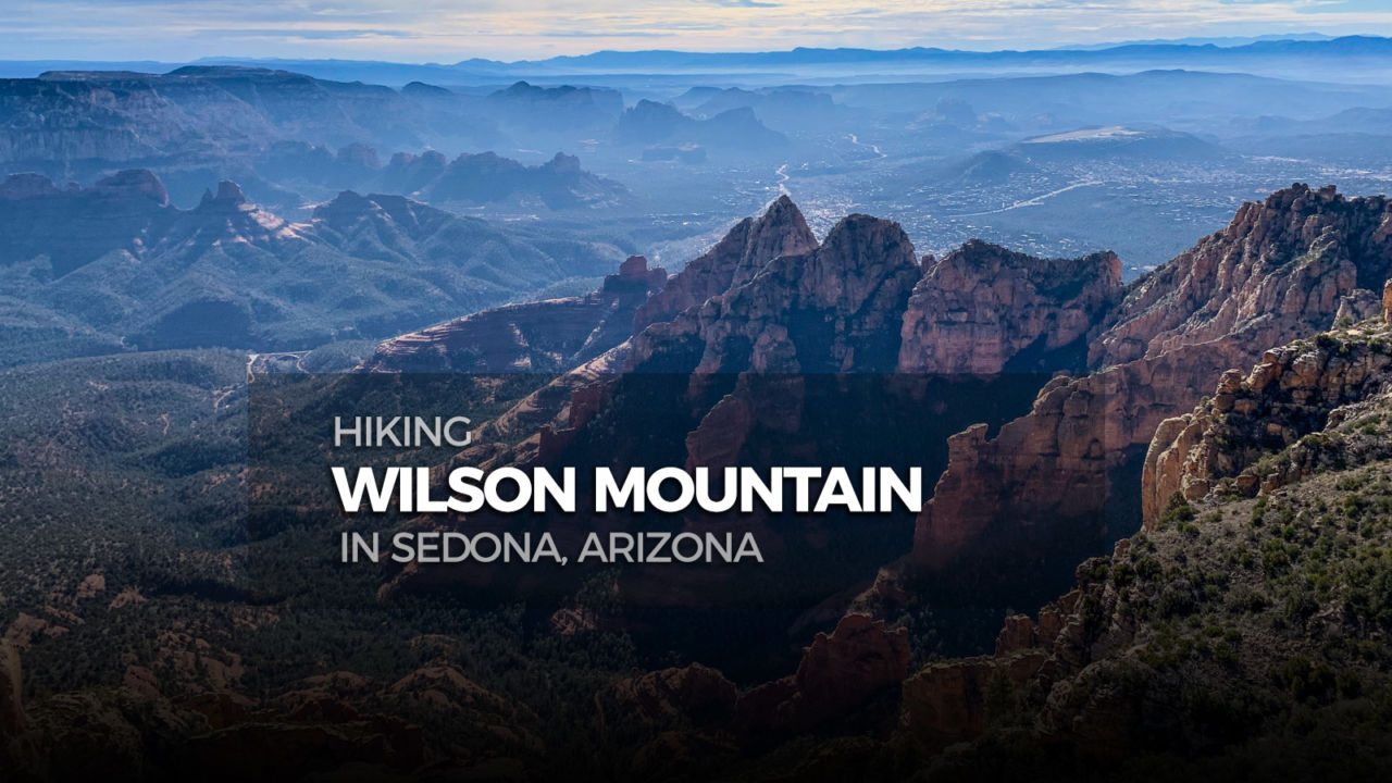
With one of the greatest overlooks in all Sedona, Wilson Mountain is a must for any Arizona hiker. This northern approach offers a cool shady canyon start and an up-close perspective of beautifully stratified red and beige rocks, before climbing onto the broad grassy mesa. Pack some snacks, plan to stay up top for a while, and fully appreciate the panoramic view.

img
Trail Details
Summit Elev.: 7,065′
Distance: 7.2 miles
Time: 4-5 hours
Difficulty: Moderately Strenuous
Elevation gain: 2,331′
Dogs: Yes
When to go: Spring, Summer, Fall

Getting to the Trailhead

From Sedona, go north on 89A. Continue 3.4 miles past Midgely Bridge. The trailhead is on the left side at the Encinoso Picnic Area. You will see a sign for the picnic area 200 ft. before the parking lot entrance.

From Flagstaff, take I-17 South to exit 337 for 89A South. At the traffic circle, take the first exit following the sign for Sedona, then at the second traffic circle take the third exit onto 89A toward Sedona. Continue 19.4 miles on 89A. The trailhead is on the right side at the Encinoso Picnic Area. You will see a sign come up for the picnic area 100 ft. before the parking lot entrance.

The parking spaces inside the gate are day-use only, since it’s for the picnic area. But, there are a few spots just outside the gate if you are hiking outside normal day-use hours. A Red Rock Pass is required for parking and can be purchased for $5 with credit/debit card from a vending machine in the parking lot. There are bathrooms at the trailhead, but no running water.

Wilson Mountain trailhead parking

Hiking Wilson Mountain

Wilson Mountain has two main routes to the top. The North Wilson Trail is the cooler of the two, so it’s the preferred route in summer. To start the hike go to the north end of the parking lot, near the lot entrance, and you’ll find a path next to a wooden frame displaying a trail map.

Trail 123 North Wilson Trailhead

A few yards beyond the map display, there’s a metal signpost that reads “TRAIL 123 NORTH WILSON”, confirming you are in the right place. The start is a little rocky, but not too steep. Around a tenth of a mile in you pass under a power line, then the views start to improve both ahead and behind.

Pine trees on the North Wilson Trail

As you reach the half mile mark, tree cover increases and you begin to enter a broad area between two ridges. You’ll start to notice evidence that this area burned back in the 2006 Brins fire. About ¾ of a mile in, the canyon becomes narrower, slightly steeper, and the trail starts to curve left toward the south end of the red rock face ahead.

Entering Red Rock Secret Mountain Wilderness

There’s a dip across a narrow streambed, then in another tenth of a mile a larger dip switchbacking left to cross the streambed again. Around the one mile mark, there is a section that can be confusing – the trail makes an abrupt left for a small switchback around some trees and boulders. Don’t be tempted to go straight or right, by the worn sidepath. Less than a quarter mile further you will reach the first of three larger switchbacks, which accelerate your ascent to the next plane. You can track your upward progress using the colorful layers of the  opposing rock wall for reference.

Layers of red rock in Sedona

This section is followed by many tight steeper switchbacks which bring you up onto a large flat area referred to as the “First Bench” of Wilson Mountain. After about a half mile of travel along this “bench”, you’ll come to a three-way intersection. Turn right, following the sign arrow pointing to “WILSON MTN”.

Wilson Mountain Trail Junction

Once you make the right turn, the trail heads uphill aiming just north of the peak. Half a mile from the junction you hit the first turn of a long switchback, then a quarter mile further you finish the switchback turning right and continuing up onto the mesa. A mix of trees returns, both standing and downed, as the trail curves gently left bringing you to the final saddle with another three-way intersection.

Sedona Overlook Junction

At this juncture go left, following the arrow pointing to “SEDONA OVERLOOK”. This is a good time to check that your socks are on tight, because the view ahead may knock them off. The trail rises up and over the highest elevation of the hike, but the real view is a quarter mile further at the plateau’s southern edge.

Be careful once you get to the rim, because it’s a precipitous drop to the bottom.

Wilson Mountain Panorama

From the end of the trail you have spectacular views into Oak Creek Canyon and across Sedona. If you know where to look, you can see Midgely Bridge spanning Wilson Canyon.

Once you’ve filled your camera roll with enough pictures of the panorama, return down the way you came.

Forest on Wilson Mountain

Wilson Mountain Trail Map & Elevation Profile

© OpenStreetMap contributors
Download file: Wilson_Mountain_Sedona_.gpx

Wilson Mountain Resources

  • A Red Rock Pass for parking is required and can be purchased at the trailhead vending
    machine – $5 for the day or $15 for the week – More info on Red Rock Pass
  • Forest Service’s web pages with info on both trails used for this route:
    • North Wilson Trail #123
    • Wilson Mountain Trail #10

Sedona Weather Forecast

The location could not be found.

Arizona Summer Six-Pack of Peaks Challenge

Arizona Six-Pack of Peaks Challenge – Summer Edition

This hike is part of the Arizona Six-Pack of Peaks Challenge – Summer Edition. This self-paced hiking challenge includes six hikes all easily reached from the great Phoenix metropolitan area. They are a great way to explore the area, train for bigger adventures, and you’ll be doing good, with a portion of the net proceeds going to support Big City Mountaineers.

Registration for the summer challenge opens April 1st! Be sure to check out the winter challenge, too!

Filed Under: Trail Guides Tagged With: 6-8 miles, Arizona, Coconino National Forest, dog-friendly, peak, peakbagging, Red Rock Secret Mountain Wilderness, Sedona, Six-Pack of Peaks, strenuous, Wilson Mountain

Like what you found here at SoCal Hiker? This site is a labor of love. Share your support for the site and help us development of new trail guides and expanded coverage -- make your next outdoor equipment purchase through our advertisers.

You can also subscribe to our weekly newsletter and follow us on Facebook or Twitter.

Richard O

About Richard Oppelaar

To me, hiking is a way to see the country in ways many people don’t. Road trips and collecting high points are my main motive. I grew up in New Jersey, discovered hiking while living in North Carolina, and have been based in Southern California since 2012. I love everything from hiking well maintained, popular trails in the Southwest to mountaineering less accessible peaks. My day job is teaching at a school where I’m lucky enough to have a small hiking club for students who I take on small excursions once a month.

Leave a Reply Cancel reply

Your email address will not be published. Required fields are marked *

This site uses Akismet to reduce spam. Learn how your comment data is processed.

About SoCal Hiker

Jeff on Mount Rainier

I created SoCal Hiker while preparing to thru-hike the John Muir Trail. My goal? Create guides for the best hiking and backpacking trails with enough detail to make it an enjoyable experience for you. And while I started with trails in Southern California, I’ve expanded across the west. We hike each trail to create these guides, sharing practical advice on gear and outdoor skills. Read more…

Connect with SoCal Hiker

  • 22,754 Fans
  • 11,943 Followers
  • 21,640 Followers
  • 1,716 Followers
  • 5,279 Subscribers
  • 339 Subscribers
SoCalHiker was selected one of USA TODAY's 10 Best Hiking and Outdoor Blogs
Get our day-by-day guide to thru-hiking the John Muir Trail
Get up-to-day wildfire status throughout California

Products

  • San Gorgonio T-Shirt $23.00 – $25.00
  • Mt Whitney Replica Benchmark Mt Whitney Benchmark $39.95
  • Let your SoCalHiker flag fly! SoCalHiker Red, White & Blue Summit Flag
    Rated 5.00 out of 5
    $25.00
  • All the Paths T-Shirt $26.50 – $28.00

Sponsors

Sponsor SoCalHiker and see your banner here

Featured Posts

Hiking Belknap Crater in the Mountain Washington Wilderness

Hiking this out-and-back route up Belknap Crater you'll traverse an other-worldly … [Read More...]

Hiking to the Simpson Reef Overlook on the Oregon Coast Trail

The Oregon Coast is rugged, beautiful and often uncrowded. This bluff-top … [Read More...]

Join Team SoCalHiker at the Climb for Heroes

Team SoCalHiker is climbing Mount Baldy again as part of the annual Climb for Heroes … [Read More...]

Lastest Comments

  • Greg on Rae Lakes Loop via Kearsarge Pass
  • Tim Wilson on Rae Lakes Loop via Kearsarge Pass
  • Pam Selthun on Backpacking the Wonderland Trail
  • Calico Maps on Hiking Monserate Mountain
  • Deborah Aguanno on Mt. Wilson via Chantry Flats
Get your SoCalHiker stickers now

Get your SoCalHiker stickers!

Latest Posts

  • Hiking Belknap Crater in the Mountain Washington Wilderness October 20, 2022
  • Hiking to the Simpson Reef Overlook on the Oregon Coast Trail August 25, 2022
  • Join Team SoCalHiker at the Climb for Heroes August 23, 2022
  • Hiking the Welch-Dickey Loop in the White Mountain National Forest August 18, 2022
  • Hiking Turtlehead Peak from Red Rock Canyon National Conservation Area July 15, 2022

Recent Forum Topics

  • How to deal with accidents while hiking in the winter?
  • Warm Tips for your hiking in winter
  • Some tips for hiking.
  • Keep your body warm in the winter hiking
  • The benefits of hiking, more than you can imagine!

The Six-Pack of Peaks Challenge Series

Six-Pack of Peaks Challenge SeriesThe Six-Pack of Peaks Challenge Series gives you an opportunity to explore your world while supporting a great cause. There are eleven challenges around the country. Hike or run them at your own schedule.

Flex your adventure muscles!

Learn more here.


Search

Tags

3-6 miles 6-8 miles 8-10 miles 11+ miles Arizona Backpacking coastal dog-friendly easy family-friendly High Sierra Trail hiking Hiking The John Muir Trail hipster inspiration JMT John Muir John Muir Trail Kings Canyon National Park LA County moderate Mount Rainier National Park Muir Monday National Park Orange County Oregon out of bounds Pacific Crest Trail peak peakbagging quote scenic Sequoia National Park Sierra Nevada Six-Pack of Peaks State Park strenuous Thru-hiking Utah vista Washington waterfall wilderness Wonderland Trail Yosemite

Copyright © 2023 SoCalHiker.net · Metro Theme on Genesis Framework with WPEngine Hosting · Contact SoCal Hiker · Sitemap · Privacy Policy


Loading Comments...