• COVID-19 Park and Trail Closures
  • Learn about the Six-Pack of Peaks Challenge
  • Shop
  •  

SoCal Hiker

  • Find a Hiking Trail
    • All Areas
    • Arizona
    • Colorado
    • Los Angeles
    • Orange County
    • Oregon
    • San Francisco Bay
    • Washington
  • Trail Guides
  • Six-Pack of Peaks
    • Colorado Six-Pack of Peaks
      • Bergen Peak
      • Rocky Mountain
      • Birthday Peak
      • Horseshoe Mountain
      • Grays Peak
    • New England Six-Pack of Peaks
    • NorCal Six-Pack of Peaks
      • Mount Umunhum
      • Mount Saint Helena
      • Mount Tamalpais
      • Mount Diablo
      • Mount Sizer
      • Rose Peak
    • Oregon Six-Pack of Peaks
      • Tumalo Mountain
      • Black Butte
      • Black Crater
      • Maiden Peak
      • Mount Bachelor
      • South Sister
    • SoCal Six-Pack of Peaks
      • Mt. Wilson
      • Cucamonga Peak
      • Mt. San Antonio (Mt Baldy)
      • San Bernardino Peak
      • San Jacinto Peak
      • San Gorgonio
  • Backpacking
    • High Sierra Trail
    • John Muir Trail
      • Overview of the John Muir Trail
      • Training
      • Day-by-Day Itinerary
      • Resupply Addresses
      • JMT Discussion Forum
    • Lost Coast Trail
    • North/South Lake Loop
    • Rae Lakes Loop
    • Red Peak Pass Loop
    • Theodore Solomons Trail
    • Trans-Catalina Trail
    • Wonderland Trail
  • Gear
  • Forums
    • Latest Topics
    • Ask a Question
    • Campfire
    • Trails
    • Trail Reports
    • Gear Wisdom
    • Classifieds
  • Login

Hiking to O’Leary Peak Lookout

March 25, 2019 By Richard Oppelaar 1 Comment

Views from O'Leary Peak near Flagstaff Arizona

Hiking O’Leary Peak will take you to the edge of a millennia old lava flow, and up high above to look down on the cinder cone that created it. From the lookout tower at the top of this lava dome, you’ll look into the heart of the San Francisco Peaks, marvel at the size of Humphrey’s Peak, and enjoy a birds eye view of Sunset Crater National Monument.

img
Trail Details
Summit Elev.: 8,916′
Distance: 10 miles
Time: 5-6 hours
Difficulty: Moderately Strenuous
Elevation gain: 2,014′
Dogs: Yes
When to go: Spring, Summer, Fall

Getting to the Trailhead

From Flagstaff, head North on Hwy 89. Eleven miles passed the Flagstaff KOA, turn right following the sign for Sunset Crater Volcano Wupatki National Monument. Continue straight on Fire Road 545 for 1.8 miles, then turn Left at the sign for O’Leary Group Campground onto Fire Road 545A.

The road dead-ends at the gated trailhead after about a quarter mile and there are spaces to park on the right. There is no bathroom or water at the trailhead.

O'Leary Peak Trailhead

Hiking O’Leary Peak

To begin the hike, pass by the gate and start walking the wide black cinder path. The first mile is a combination of flat and slight downhill, as you approach and curve left along the edge of the Bonito Lava Flow. This vast flow was created by the Sunset Crater Volcano 1,000 years ago.

As the path begins to bend northward, Darton Dome then O’Leary Peak come into view. These peaks were all created from volcanic activity, but they are different types of structures. Sunset Crater is a cinder cone, while O’Leary Peak is a lava dome.

The Bonito Lava Flow

Feel free to leave the path and explore the lava flow – the Forest Service encourages it. After investigating the inky dollops, return to the trail and continue towards the peak. The incline comes on in fits and starts during the second mile, then holds steady for the duration. Just before the two mile mark you hit the first of six switchbacks. Here the trees start to become sparse, and the view of the lava field starts to open up.

The views begin to open up at about the two mile mark.

The trail approaches a saddle, but doesn’t quite reach it before hitting the second switchback. This is by far the longest of the switchbacks. As you progress along this leg, look back to see Humphrey’s Peak rise above the trees.

Humphrey's Peak rises into view

This long switchback eventually ends at the saddle between O’Leary Peak and Darton Dome, around the 3.5 mile mark. If you look up from here, you can see the tower standing at the top of the ridge. Go left through an open gate, starting the third switchback.

Go through the gate to the left.

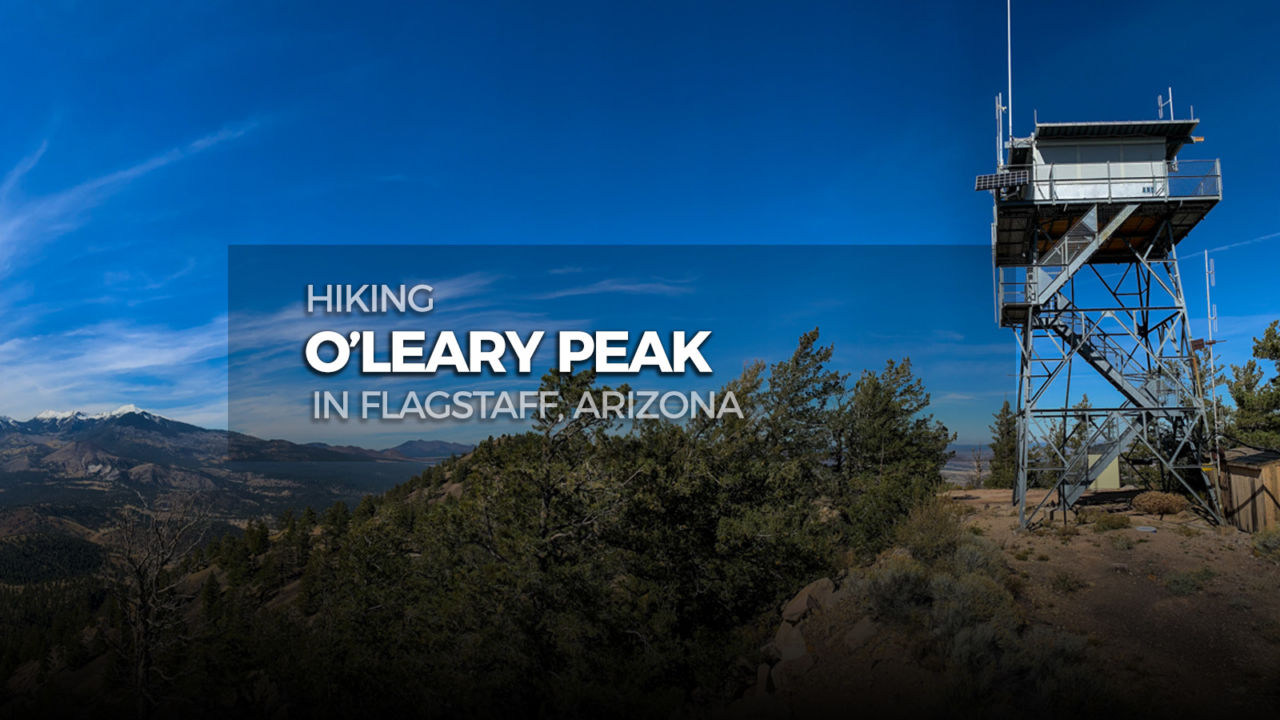
This switchback is about as long as the first. The last three are all shorter, which you’ll find start at mile 4.0, mile 4.3, and mile 4.6 At mile 4.8 you will pass by a final gate. The tower is so close, it’s visible from here!

The final gate on the way to O'Leary Peak

Continue up the final steep finish to the tower! There’s a sign next to the tower listing the hours it should be open and staffed, but I was there during open hours and it was apparently unattended. If you do hike it while there’s someone on watch, just holler up to ask for permission to climb aboard. If not, the view from around the base of the tower is certainly good enough.

View from O'Leary Peak

Take in the panoramic view spanning from Sunset Crater to the south and Humphrey’s Peak to the west. Once you’ve finished contemplating the structural differences between cinder cones and lava domes, return back down the way you came.

Heading down from O'Leary Peak

Forested trail from O'Leary Peak

O’Leary Peak Trail Map & Elevation Profile

© OpenStreetMap contributors
Download file: O_Leary_Peak_Lookout_Arizona_8_916_w_S.gpx

O’Leary Peak Resources

  • Dogs are allowed, but be aware that the dark gravel trails may get too hot for Fido’s paws.
  • Forest Service’s web pages with info on the O’Leary Peak Trail

Flagstaff Weather Forecast

The location could not be found.

Arizona Summer Six-Pack of Peaks Challenge

Arizona Six-Pack of Peaks Challenge – Summer Edition

This hike is part of the Arizona Six-Pack of Peaks Challenge – Summer Edition. This self-paced hiking challenge includes six hikes all easily reached from the Flagstaff/Sedona area. They are a great way to explore the area, train for bigger adventures, and you’ll be doing good, with a portion of the net proceeds going to support Big City Mountaineers.

Registration for the summer challenge opens April 1st! Be sure to check out the winter challenge, too!

Filed Under: Trail Guides Tagged With: 8-10 miles, Arizona, Coconino National Forest, dog-friendly, Flagstaff, O'Leary Peak, peakbagging, Six-Pack of Peaks, strenuous

Like what you found here at SoCal Hiker? This site is a labor of love. Share your support for the site and help us development of new trail guides and expanded coverage -- make your next outdoor equipment purchase through our advertisers.

You can also subscribe to our weekly newsletter and follow us on Facebook or Twitter.

Richard O

About Richard Oppelaar

To me, hiking is a way to see the country in ways many people don’t. Road trips and collecting high points are my main motive. I grew up in New Jersey, discovered hiking while living in North Carolina, and have been based in Southern California since 2012. I love everything from hiking well maintained, popular trails in the Southwest to mountaineering less accessible peaks. My day job is teaching at a school where I’m lucky enough to have a small hiking club for students who I take on small excursions once a month.

Comments

  1. I love travelling says

    February 4, 2020 at 9:39 pm

    am so happy to read everything about travelling. It provides me with information on the best places to travel.

    Reply

Leave a Reply Cancel reply

Your email address will not be published. Required fields are marked *

This site uses Akismet to reduce spam. Learn how your comment data is processed.

About SoCal Hiker

Jeff on Mount Rainier

I created SoCal Hiker while preparing to thru-hike the John Muir Trail. My goal? Create guides for the best hiking and backpacking trails with enough detail to make it an enjoyable experience for you. And while I started with trails in Southern California, I’ve expanded across the west. We hike each trail to create these guides, sharing practical advice on gear and outdoor skills. Read more…

Connect with SoCal Hiker

  • 22,751 Fans
  • 11,946 Followers
  • 21,640 Followers
  • 1,717 Followers
  • 5,281 Subscribers
  • 342 Subscribers
SoCalHiker was selected one of USA TODAY's 10 Best Hiking and Outdoor Blogs
Get our day-by-day guide to thru-hiking the John Muir Trail
Get up-to-day wildfire status throughout California

Products

  • South Sister Benchmark South Sister Benchmark $39.95
  • Half Dome replica benchmark Half Dome Benchmark $39.95
  • San Bernardino Peak Mug San Bernardino Peak Mug $15.95
  • Let your SoCalHiker flag fly! SoCalHiker Red, White & Blue Summit Flag
    Rated 5.00 out of 5
    $25.00

Sponsors

Sponsor SoCalHiker and see your banner here

Featured Posts

Hiking Belknap Crater in the Mountain Washington Wilderness

Hiking this out-and-back route up Belknap Crater you'll traverse an other-worldly … [Read More...]

Hiking to the Simpson Reef Overlook on the Oregon Coast Trail

The Oregon Coast is rugged, beautiful and often uncrowded. This bluff-top … [Read More...]

Join Team SoCalHiker at the Climb for Heroes

Team SoCalHiker is climbing Mount Baldy again as part of the annual Climb for Heroes … [Read More...]

Lastest Comments

  • Amy Courtney on Ridgeline Trail
  • Jay Eleanor on Hiking to the Simpson Reef Overlook on the Oregon Coast Trail
  • Charles Krim on Hiking to the Simpson Reef Overlook on the Oregon Coast Trail
  • 11 Best California Bikepacking Routes | Wild Lumens on Inside Crystal Cove State Park
  • Ted Thed on Burbank Peak, Cahuenga Peak, Mt. Lee and the Hollywood Sign
Get your SoCalHiker stickers now

Get your SoCalHiker stickers!

Latest Posts

  • Hiking Belknap Crater in the Mountain Washington Wilderness October 20, 2022
  • Hiking to the Simpson Reef Overlook on the Oregon Coast Trail August 25, 2022
  • Join Team SoCalHiker at the Climb for Heroes August 23, 2022
  • Hiking the Welch-Dickey Loop in the White Mountain National Forest August 18, 2022
  • Hiking Turtlehead Peak from Red Rock Canyon National Conservation Area July 15, 2022

Recent Forum Topics

  • How to deal with accidents while hiking in the winter?
  • Warm Tips for your hiking in winter
  • Some tips for hiking.
  • Keep your body warm in the winter hiking
  • The benefits of hiking, more than you can imagine!

The Six-Pack of Peaks Challenge Series

Six-Pack of Peaks Challenge SeriesThe Six-Pack of Peaks Challenge Series gives you an opportunity to explore your world while supporting a great cause. There are eleven challenges around the country. Hike or run them at your own schedule.

Flex your adventure muscles!

Learn more here.


Search

Tags

3-6 miles 6-8 miles 8-10 miles 11+ miles Arizona Backpacking coastal dog-friendly easy family-friendly High Sierra Trail hiking Hiking The John Muir Trail hipster inspiration JMT John Muir John Muir Trail Kings Canyon National Park LA County moderate Mount Rainier National Park Muir Monday National Park Orange County Oregon out of bounds Pacific Crest Trail peak peakbagging quote scenic Sequoia National Park Sierra Nevada Six-Pack of Peaks State Park strenuous Thru-hiking Utah vista Washington waterfall wilderness Wonderland Trail Yosemite

Copyright © 2023 SoCalHiker.net · Metro Theme on Genesis Framework with WPEngine Hosting · Contact SoCal Hiker · Sitemap · Privacy Policy


Loading Comments...