• COVID-19 Park and Trail Closures
  • Learn about the Six-Pack of Peaks Challenge
  • Shop
  •  

SoCal Hiker

  • Find a Hiking Trail
    • All Areas
    • Arizona
    • Colorado
    • Los Angeles
    • Orange County
    • Oregon
    • San Francisco Bay
    • Washington
  • Trail Guides
  • Six-Pack of Peaks
    • Colorado Six-Pack of Peaks
      • Bergen Peak
      • Rocky Mountain
      • Birthday Peak
      • Horseshoe Mountain
      • Grays Peak
    • New England Six-Pack of Peaks
    • NorCal Six-Pack of Peaks
      • Mount Umunhum
      • Mount Saint Helena
      • Mount Tamalpais
      • Mount Diablo
      • Mount Sizer
      • Rose Peak
    • Oregon Six-Pack of Peaks
      • Tumalo Mountain
      • Black Butte
      • Black Crater
      • Maiden Peak
      • Mount Bachelor
      • South Sister
    • SoCal Six-Pack of Peaks
      • Mt. Wilson
      • Cucamonga Peak
      • Mt. San Antonio (Mt Baldy)
      • San Bernardino Peak
      • San Jacinto Peak
      • San Gorgonio
  • Backpacking
    • High Sierra Trail
    • John Muir Trail
      • Overview of the John Muir Trail
      • Training
      • Day-by-Day Itinerary
      • Resupply Addresses
      • JMT Discussion Forum
    • Lost Coast Trail
    • North/South Lake Loop
    • Rae Lakes Loop
    • Red Peak Pass Loop
    • Theodore Solomons Trail
    • Trans-Catalina Trail
    • Wonderland Trail
  • Gear
  • Forums
    • Latest Topics
    • Ask a Question
    • Campfire
    • Trails
    • Trail Reports
    • Gear Wisdom
    • Classifieds
  • Login

Hiking the Welch-Dickey Loop in the White Mountain National Forest

August 18, 2022 By Jeff H 1 Comment

Hiking the Welch-Dickey Loop

This 4.8 mile loop in New Hampshire’s White Mountain National Forest takes you up and over both Welch and Dickey Mountain. This trail has challenging sections of granite, with some Class 2 scrambling. It’s fun, challenging hike with rewarding views of the surrounding mountains.

img
Trail Details
Summit Elevation: Welch Mountain 2,605′; Dickey Mountain 2,733′
Distance: 4.8 miles
Time: 3-4 hours
Difficulty: Strenuous
Elevation gain: 1,802 ft
Dogs: Yes
When to go: Year-round
First, you’ll want to hike this loop counter-clockwise. Trust me on this. There are granite slabs that you’ll have to ascend on Welch Mountain that you will not want to descend. Second, you’ll want to hike this in dry conditions. If it’s wet or icy, skip it, again due to the extensive hiking on granite slabs.

Getting to the Welch-Dickey Trailhead

This is an easy trailhead to reach, less than six miles east of I-93. Head east on NH-49 for 5.5 miles, turning left on Upper Mad River Road. Go 0.7 miles and turn right on Orris Road, then follow it for 0.5 miles to the trailhead. You can get turn-by-turn directions to the trailhead here via Google Maps.

Welch-Dickey Trailhead parking
Parking area
Welch-Dickey trailhead information
LNT, dogs and other considerations

Beginning of the trail
First few steps on the trail
Welch-Dickey trail sign
This sign is a few yards up from the trailhead

The trailhead has pit toilets, and requires a WMNF pass (an annual National Parks pass will also work) or a $5 day use fee, payable by cash in envelopes provided at the trailhead. The lot has plenty of parking, but this is a popular hike and it can fill up on weekends.

Hiking the Welch-Dickey Loop

The trail begins at the north end of the parking area near the information signs (be sure to check them for the latest warnings and restrictions). You’ll head into the woods for 20-30 feet before you reach the first trail sign. At this point, bear right to take the loop counter-clockwise, starting with Welch Mountain.

Water crossing early on the trail
Rocks. Lots of rocks.

Yellow blazes

The first mile climbs through well shaded forest on a rocky, root-covered trail. There are yellow blazes on trees to help keep you on the trail. Shortly after the first mile, you reach your first expanse of granite. Take a walk to the ledge and enjoy the view. The exciting part is just ahead.

First stretch of granite
Head to the edge for a viewpoint
Welch Mountain ahead


From the viewpoint, the granite slabs get steeper, with some Class 2 scrambling in sections. Follow the yellow blazes, sometimes painted on the granite and other times on the trunks of trees.

Yes, you’ll have to squeeze through this crack and scramble out of it.

It gets a bit easier as you approach the summit of Welch Mountain.

Welch Mountain summit selfie

The summit of Welch Mountain is a good spot to take a break and soak in the views. From here, the trail descends to a saddle before climbing again to the taller Dickey Mountain.

Cairn at the saddle between Welch and Dickey Mountain

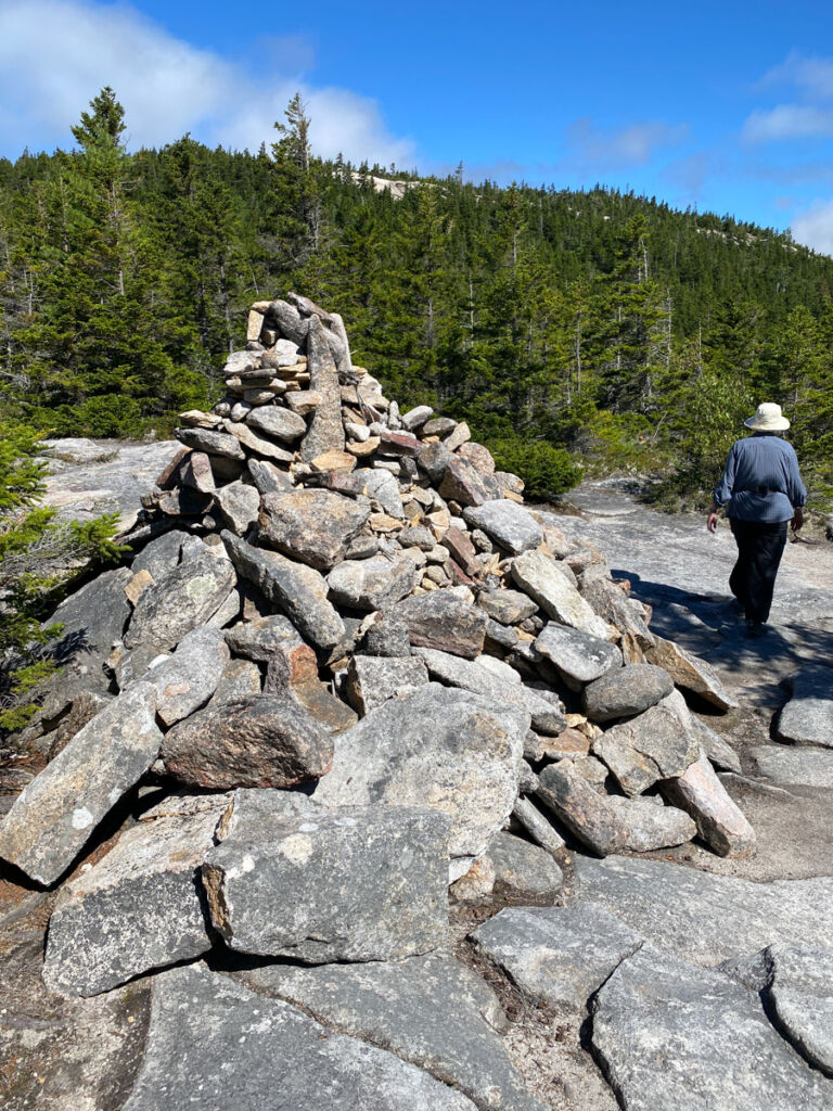
At the saddle there is one of the largest cairns on the route. Look closely for the continuation of the trail. It’s easy to miss.

Once again, you’ll scramble up granite slabs that are sometimes quite steep. It’s easy to see why most people prefer to hike this loop counter-clockwise, as these sections are much easier to climb than to descend.

The summit of Dickey Mountain, though taller than Welch, has more trees. Still there are plenty of granite slabs where you can stretch out in the sun and enjoy the view.

From Welch Mountain, the trail descends for about a mile of granite that’s thankfully not quite as exciting as what you climbed on your ascent. The trickiest part here is finding the trail, as the blazes are sometimes far and few between. This is where it pays to take your time and check your GPS location periodically to make sure you stay on course.

Occasional cairns
Following sun-baked blazes painted on the granite

Dipping back into the woods

The final section of granite includes this view, with a cliff dropping off to your left.

And finally you return to dirt… and roots… and rocks. It’s not a smooth trail, but it’s fairly easy to follow.

The trail descends along a ridge towards the trailhead, heading due south. Keep your eyes open for mushrooms along the trail.

First signs of autumn

At 4.7 miles you’ll come to the junction with the Dinkey Notch Trail. Turn left here to hike the final 10th of a mile back to the trailhead parking area.

At under five miles, this trail is not long and won’t take all day. It has some fun sections that require you to problem solve your way up and down. And the views of the surrounding mountains were stunning.

After our hike, we headed to North Woodstock and stopped at the Woodstock Inn Brewery for lunch (they have a wonderful outdoor patio).

Welch-Dickey Loop Trail Map & Elevation Profile

© OpenStreetMap contributors
Download file: Welch_Dickey_Loop.gpx

Welch-Dickey Loop Resources

  • We had cell reception on the summits and most (but not all) of the trail. We had zero cell reception at the trailhead.
  • Note that the mileage stated on the trail signs indicated the loop was 4.5 miles. We recorded 4.8 on our GPS.
  • Check the weather in nearby Campton, NH for a rough idea of what to expect on this hike.
  • Check out the latest hike logs on Social Hiker for current trail conditions.

Six-Pack of Peaks Challenge SeriesThe New England Six-Pack of Peaks Challenge

The Welch-Dickey Loop is part of the New England Six-Pack of Peaks Challenge, a self-paced hiking challenge that takes you up six iconic mountains, each a bit higher and harder. It’s a challenge in itself, or a great way to train for bigger adventures. And your registration help support some great outdoor-related non-profits.

Learn more and sign-up here.

Originally hiked on August 12, 2022 with Joan. 

Filed Under: Trail Guides Tagged With: Class 2, Dickey Mountain, New Hampshire, Six-Pack of Peaks, strenuous, Welch Mountain, White Mountain National Forest

Like what you found here at SoCal Hiker? This site is a labor of love. Share your support for the site and help us development of new trail guides and expanded coverage -- make your next outdoor equipment purchase through our advertisers.

You can also subscribe to our weekly newsletter and follow us on Facebook or Twitter.

Jeff H

About Jeff H

I'm an avid hiker and backpacker. My wife Joan and I are on the trails every weekend. I started SoCal Hiker to share my passion for outdoor adventure.

Comments

  1. Daniel says

    August 26, 2022 at 10:00 am

    These are some beautiful views from the top. It makes me want to do more hiking outside of the So-Cal region. Thanks for sharing!

    Reply

Leave a Reply Cancel reply

Your email address will not be published. Required fields are marked *

This site uses Akismet to reduce spam. Learn how your comment data is processed.

About SoCal Hiker

Jeff on Mount Rainier

I created SoCal Hiker while preparing to thru-hike the John Muir Trail. My goal? Create guides for the best hiking and backpacking trails with enough detail to make it an enjoyable experience for you. And while I started with trails in Southern California, I’ve expanded across the west. We hike each trail to create these guides, sharing practical advice on gear and outdoor skills. Read more…

Connect with SoCal Hiker

  • 22,735 Fans
  • 11,942 Followers
  • 21,640 Followers
  • 1,717 Followers
  • 5,275 Subscribers
  • 338 Subscribers
SoCalHiker was selected one of USA TODAY's 10 Best Hiking and Outdoor Blogs
Get our day-by-day guide to thru-hiking the John Muir Trail
Get up-to-day wildfire status throughout California

Products

  • Poster - One touch of nature makes the whole world kin. - John Muir One Touch of Nature Poster $13.00 – $16.00
  • Half Dome replica benchmark Half Dome Benchmark $39.95
  • #MuirTaco stickers Muir Taco Stickers (2-pack) $3.00
  • 2017 Six-Pack of Peaks Patch 2017 Six-Pack of Peaks Patch
    Rated 5.00 out of 5
    $6.00

Sponsors

Sponsor SoCalHiker and see your banner here

Featured Posts

Hiking Belknap Crater in the Mountain Washington Wilderness

Hiking this out-and-back route up Belknap Crater you'll traverse an other-worldly … [Read More...]

Hiking to the Simpson Reef Overlook on the Oregon Coast Trail

The Oregon Coast is rugged, beautiful and often uncrowded. This bluff-top … [Read More...]

Join Team SoCalHiker at the Climb for Heroes

Team SoCalHiker is climbing Mount Baldy again as part of the annual Climb for Heroes … [Read More...]

Lastest Comments

  • Greg on Rae Lakes Loop via Kearsarge Pass
  • Tim Wilson on Rae Lakes Loop via Kearsarge Pass
  • Pam Selthun on Backpacking the Wonderland Trail
  • Calico Maps on Hiking Monserate Mountain
  • Deborah Aguanno on Mt. Wilson via Chantry Flats
Get your SoCalHiker stickers now

Get your SoCalHiker stickers!

Latest Posts

  • Hiking Belknap Crater in the Mountain Washington Wilderness October 20, 2022
  • Hiking to the Simpson Reef Overlook on the Oregon Coast Trail August 25, 2022
  • Join Team SoCalHiker at the Climb for Heroes August 23, 2022
  • Hiking the Welch-Dickey Loop in the White Mountain National Forest August 18, 2022
  • Hiking Turtlehead Peak from Red Rock Canyon National Conservation Area July 15, 2022

Recent Forum Topics

  • How to deal with accidents while hiking in the winter?
  • Warm Tips for your hiking in winter
  • Some tips for hiking.
  • Keep your body warm in the winter hiking
  • The benefits of hiking, more than you can imagine!

The Six-Pack of Peaks Challenge Series

Six-Pack of Peaks Challenge SeriesThe Six-Pack of Peaks Challenge Series gives you an opportunity to explore your world while supporting a great cause. There are eleven challenges around the country. Hike or run them at your own schedule.

Flex your adventure muscles!

Learn more here.


Search

Tags

3-6 miles 6-8 miles 8-10 miles 11+ miles Arizona Backpacking coastal dog-friendly easy family-friendly High Sierra Trail hiking Hiking The John Muir Trail hipster inspiration JMT John Muir John Muir Trail Kings Canyon National Park LA County moderate Mount Rainier National Park Muir Monday National Park Orange County Oregon out of bounds Pacific Crest Trail peak peakbagging quote scenic Sequoia National Park Sierra Nevada Six-Pack of Peaks State Park strenuous Thru-hiking Utah vista Washington waterfall wilderness Wonderland Trail Yosemite

Copyright © 2023 SoCalHiker.net · Metro Theme on Genesis Framework with WPEngine Hosting · Contact SoCal Hiker · Sitemap · Privacy Policy


Loading Comments...