
A little over two years ago, Derek (@100Peaks), Peter (@ADKinLA) and I journeyed out into the Anza Borrego desert and hiked up Whale Peak. Thus was born the first Hiking Blogger Summit. Last year we had an expanded gathering with a hike in the local Schabarum Regional Park. And this weekend, Derek, Peter and I were joined by Josh (@CaliFromMyLens) and Zac (@ZacApplegate) for another summit adventure.
Time: ~6 hours
Difficulty: Strenuous
Elevation gain: 3,920 ft
Dogs: Yes
When to go: Year-round
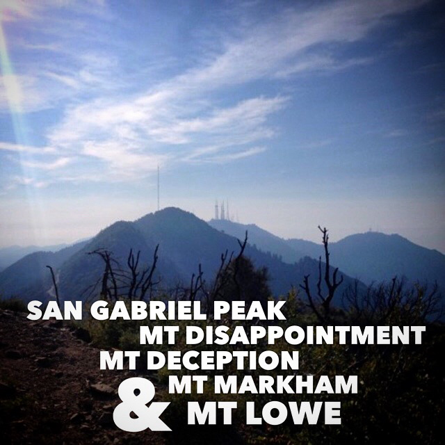
Here are the five peaks, in order of ascent:
- San Gabriel Peak – 6,161 ft.
- Mt. Disappointment – 5,963 ft.
- Mt. Deception – 5,796 ft.
- Mt. Markham – 5,728 ft.
- Mt. Lowe – 5,574 ft.
The Tale of the Trail
At 8am, we met at the Eaton Saddle trailhead, at an elevation of 5,120 feet. Our trail began on a fire road littered with rocks, reminding us that this area is prone to rock slides.

As you round the first bend, the Mueller Tunnel comes into view. This tunnel was originally built in 1942. About 100 yards long, it suffered a major collapse in 2007, but has since been repaired. While this tunnel used to be technically passable by vehicles, the road is now blocked by several large boulders near the entrance–still plenty of room for hikers and mountain bikers to weave through.

At the 1/2 mile mark, we reached the junction at a water tank. To the left, the trail heads to Mt. Lowe. We headed to the right, toward our first summit of the day, San Gabriel Peak.
The mountain still bears scars from the Station Fire in 2009. You hike through eerie stands of dead, charred manzanita that once shaded the trail.

There are some trees that have survived, but one of the most common plants you’ll encounter on these trails is the dreaded Poodle Dog Bush. This invasive species thrives in areas scarred by wildfires. It has a pungent odor and purple flowers when blossoming. The Poodle is said to be more dangerous than poison oak. Contact can cause a rash, blistering or even severe respiratory distress.

You can see the Poodle Dog Bush here, very green and lush. On most of the trail we were able to avoid contact, with the exception of Mt. Markham. I was thankful I had long sleeves and long pants on that segment, as incidental contact became unavoidable. It is said that the symptoms can take a few days to show up, so exercise caution with this plant.
At Mile 1, we reached a second junction. To the left is Mt Disappointment. We followed the trail to the right for the final .36 miles to the summit of San Gabriel Peak.
The summit of San Gabriel Peak is marked with a cairn. There’s also a makeshift steel bench and the remnants of the foundation from a structure long since gone.

We signed the summit register, soaked in the views, and headed back down to the junction, this time heading toward the communications towers atop Mt. Disappointment. This “trail” is a paved, private access road for the communications equipment. The summit itself is aptly named. There’s not really a notable peak anymore. It was leveled and used as Nike missile site from 1955-1965.

How did Mt. Disappointment get its name? The name dates back to 1894, when USGS surveyors were mapping the area. They initially thought it to be the highest peak in the immediate area, but were “disappointed” to find that nearby San Gabriel Peak was 167 feet higher. They had to move all their gear over there for their next triangulation point.
Two peaks down, we turned back down the paved access road, this time turning left (west) and heading to Mt. Deception. At 3.1 miles, there is a dirt trail off the left (south) side of the road. Follow that up a steep slope with loose rock. Trekking poles would be handy here. The trail continues west for another 0.4 miles to the summit of Mt. Deception. This summit is not very prominent, and thick with brush. We signed our third trail register, and retraced our steps back to the original junction at the water tank.
It was 11:40am. We had hiked nearly 5.25 miles, and it was time for a decision. Do we take the easy half mile back to the cars? Or do we bag a couple more peaks? Inspired by the vision of a well-earned meal afterwards, we opted to hike yet another, and headed up the trail to Mt. Lowe.
At the 5.8 mile mark, we reached the junction to Mt. Markham. Mt. Markham is taller than Mt. Lowe, and the trail is steep and tough. There were steep sections where it was helpful to use your hands to scramble up the rocks. And the dreaded Poodle Dog Bush was unavoidable. But the reward at the summit is a remarkable stone cairn.

Four peaks down. One to go.
We retraced our steps to the junction with the Mt. Lowe trail, and headed out for one more peak. At mile 6.8, we reached the junction with a trail that heads towards Mt. Wilson. We turned right, heading upward and winding around to the summit of Mt. Lowe.

At mile 7, the last junction before the summit. If in doubt, head uphill, since you’re only 1/10th of a mile from the summit of Mt. Lowe.

After five hours and seven miles of hiking, we reached our fifth summit: Mt. Lowe. There is very little shade, but there is a nice bench. You’ve got great views in all directions, and a series of “peak spotters” posted to help you identify neighboring summits.

Mt. Lowe is named for Professor Thaddeus S. C. Lowe, who in the late 1800’s built a scenic mountain railway from Alta Dena to the base of Mt. Lowe. The railway as well as the hotel and chalet at Echo Mountain have been gone for years — victim to a series of disasters.
From here, we headed back down the trail–an easy, gradual two mile downhill trek to our cars.
Five Peaks Trail Map

Photo Gallery
Click on any photo to view a larger version. You can also leave comments on any photo.


Advice for Hiking San Gabriel Peak
- The trailhead parking requires a National Forest Adventure Pass. You can pick this up at many SoCal sporting goods stores.
- This trail is hot and dry, and there are no water sources. Bring plenty of water and food for energy. It can be uncomfortably hot in the summer.
- There is very little shade on the trail. Wear sun protection.
- The poisonous Poodle Dog Bush is prevalent. Avoid contact. Wear long sleeves and long pants.
- Trekking poles are recommended on Mt Deception and Mt Markham.
- There can be snow up here in the winter months. Plan and dress accordingly, and check for road closures.
- Dogs are allowed on these trails, but keep them on leash.
- We encountered one rattlesnake, but there are many more. Stay alert.
Other San Gabriel Peak Resources
- GPS user? Download the GPX file.
- View the trail in Google Earth.
- Trailhead directions via Google Maps
- San Gabriel Peak – Dan’s Hiking Pages (note that the tunnel has in fact reopened)
- Mt Lowe Fire Road to San Gabriel Peak – Hikespeak
Get a Second Opinion
This being a group of five hiking bloggers, we all have opinions. I’ll post links to the posts from the other hikers as they go live.
- 5 Peaks, 5-ish Hours – Hiking San Gabriel Mountain – Peter
- Five Peaks in the San Gabriels: An Epic One Day Adventure – Josh & Zac
San Gabriel Peak Weather Forecast
[forecast width=”100%” location=”Mt Wilson, CA”]

You must be logged in to post a comment.