• COVID-19 Park and Trail Closures
  • Learn about the Six-Pack of Peaks Challenge
  • Shop
  •  

SoCal Hiker

  • Find a Hiking Trail
    • All Areas
    • Arizona
    • Colorado
    • Los Angeles
    • Orange County
    • Oregon
    • San Francisco Bay
    • Washington
  • Trail Guides
  • Six-Pack of Peaks
    • Colorado Six-Pack of Peaks
      • Bergen Peak
      • Rocky Mountain
      • Birthday Peak
      • Horseshoe Mountain
      • Grays Peak
    • New England Six-Pack of Peaks
    • NorCal Six-Pack of Peaks
      • Mount Umunhum
      • Mount Saint Helena
      • Mount Tamalpais
      • Mount Diablo
      • Mount Sizer
      • Rose Peak
    • Oregon Six-Pack of Peaks
      • Tumalo Mountain
      • Black Butte
      • Black Crater
      • Maiden Peak
      • Mount Bachelor
      • South Sister
    • SoCal Six-Pack of Peaks
      • Mt. Wilson
      • Cucamonga Peak
      • Mt. San Antonio (Mt Baldy)
      • San Bernardino Peak
      • San Jacinto Peak
      • San Gorgonio
  • Backpacking
    • High Sierra Trail
    • John Muir Trail
      • Overview of the John Muir Trail
      • Training
      • Day-by-Day Itinerary
      • Resupply Addresses
      • JMT Discussion Forum
    • Lost Coast Trail
    • North/South Lake Loop
    • Rae Lakes Loop
    • Red Peak Pass Loop
    • Theodore Solomons Trail
    • Trans-Catalina Trail
    • Wonderland Trail
  • Gear
  • Forums
    • Latest Topics
    • Ask a Question
    • Campfire
    • Trails
    • Trail Reports
    • Gear Wisdom
    • Classifieds
  • Login

Escondido Falls

March 7, 2013 By Jeff H 11 Comments

Upper Escondido Falls in Malibu

Waterfalls in Malibu? You bet! In fact, the multi-tiered, 150 foot Escondido Falls are the highest waterfalls in the Santa Monica Mountains. This is an easy hike through oak-lined Escondido Canyon, just off Pacific Coast Highway in the middle of Malibu.

Trail Details
Distance: 3.6 miles
Time: ~2 hours
Difficulty: Easy
Elevation gain: 351 ft
Dogs: Yes, on leash
When to go: Spring
There are a few of things you should know before you hike to Escondido Falls. First, parking is in a small lot on PCH. It fills up early, with overflow parking on the shoulder of PCH that can extend your walk considerably (Read: GET THERE EARLY).

Second, the first 3/4 mile is actually on a residential road. Don’t complain. It is what it is.

Third, this is a very popular trail. Don’t expect solitude, especially at the waterfall.

And finally, while the trail itself is pretty easy, with nothing more challenging than rock-hopping at a few creek crossings, getting to the larger, more impressive upper tier of falls requires some boulder scrambling. I would be reluctant to take preteens, the elderly or anyone who doesn’t like climbing up and down boulders beyond the lower falls. You’ve been warned!

Getting to the trailhead is easy. There is a small lot at the intersection of Winding Way and Pacific Coast Highway, with overflow parking along PCH. The hike mileage begins at this lot.

For the first 3/4 of a mile, you’ll follow the “trail” alongside Winding Way. Keep in mind that residents do actually drive along this road, so stick to the trail on the shoulder. Like the sign says, please stay on the trail.

Stick to the shoulder of the road for the first 3/4 mile.

At .75 miles, you’ll see the actual trail into Escondido Canyon peel off to the left. Follow this trail down into the oak-lined canyon.

The trail heads down into Escondido Canyon

The trail through Escondido Canyon is easy, with a few fun creek crossings to keep it interesting. The trail is open to hikers, mountain bikes (I saw some tire tracks, but no bikers) and horses. Dogs on leash are also allowed.

An easy trail to hike

There are some amazing, majest oak trees along the canyon trail.

Majestic oak trees

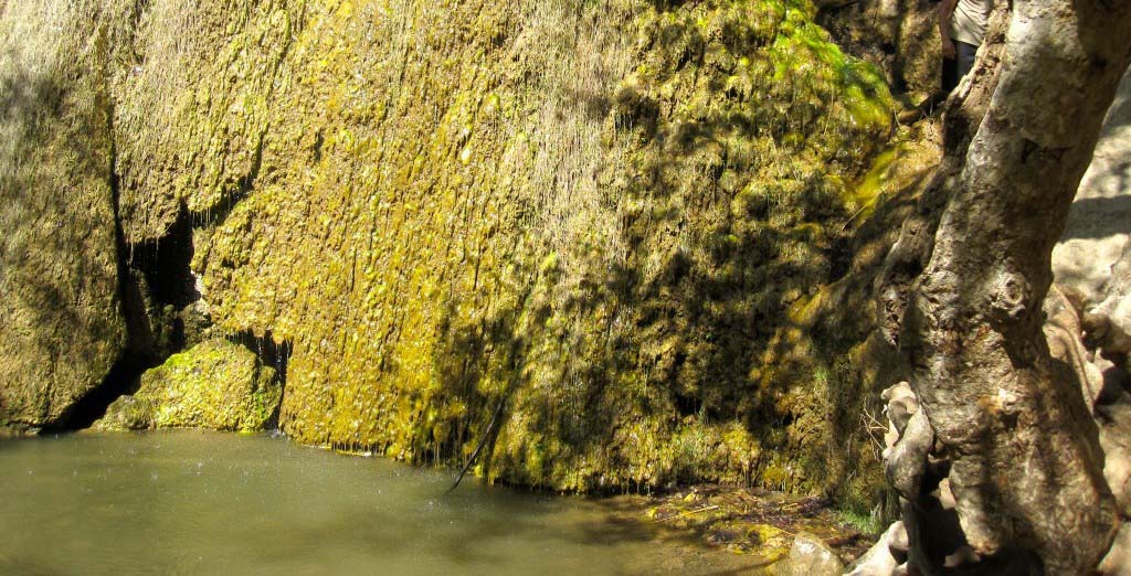
Once you get to the lower tier of the falls, you’ll notice a strong sulphuric odor. These falls are nice, but the bigger falls are in the upper tier, which requires some scrambling to get to.

En route to the upper tier, take time to look back down over Escondido Canyon. You can see the Pacific Ocean and islands off the coastline.

View out over Escondido Canyon

Upper Escondido Falls has multiple tiers, and you may see people scrambling up behind the first tier, where they can take a photo from behind the falls. The falls are best viewed soon after rainfall, and slow to a trickle at other times.

The many tiers

Notes from the SoCal Hiker

This was a nice little hike. It was an easy drive from LA, and fun to be along the coast on a warm day. The trail was busier than I prefer, but mainly because it is so accessible. The hike to the lower falls was easy, but the scramble to the upper falls requires more. Some of the people I saw attempting it with older folks or younger children were really struggling, and I would advise against it.

I also saw quite a bit of poison oak along that segment, so keep your eyes open and watch what you’re walking into to!

The most disappointing thing about this hike? The trash. There were many plastic water bottles strewn around and near the falls. Please, pack it out. Leave no trace. And if you see some trash, pick it up.

Trail Map

© OpenStreetMap contributors
Download file: Escondido_Falls1.gpx

Photo Gallery

Click on any photo to view a larger version. You can also leave comments on any photo.

Stick to the shoulder of the road for the first 3/4 mile.
Starting out on Winding Way
The trail heads down into Escondido Canyon
An easy trail to hike
Majestic oak trees
Majestic oak trees
The lower tier of Escondido Falls
Scrambling to the upper tier
View out over Escondido Canyon
Upper Escondido Falls
Upper Escondido Falls in Malibu
Cool pool
The many tiers
The many tiers
Escondido Falls
Escondido Falls
Using a makeshift rope to navigate back down
Flowering plants
Flowering plants
A closer look
A closer look
Santa Monica Mountains Conservancy Sign
Serious iced tea
Serious iced tea
Organic beer from Yorkshire

More Escondido Falls Trail Resources

These guides give other views, information and perspectives on hiking to Escondido Falls.

  • Escondido Canyon Park – from the Santa Monica Mountains Conservancy
  • California Through My Lens – My buddy Josh hiked Escondido Falls and shares his perspective and some great photos.
  • Post-hike Lunch – After the hike, you’ve earned lunch. Check out The Plate a few miles south of the trailhead in Malibu. Good food, organic ingredients, and hiker-friendly. Joan had one of their herbal iced teas (check the gallery for the details) and a garden burger. I had the turkey burger with sweet potato fries, washed down with an organic lager from a small brewery in Yorkshire. Perfect!
  • Looking for more waterfall hikes? Here you go.

Escondido Falls Weather Forecast

The location could not be found.

Related

Filed Under: Trail Guides Tagged With: dog-friendly, Malibu, waterfall

Like what you found here at SoCal Hiker? This site is a labor of love. Share your support for the site and help us development of new trail guides and expanded coverage -- make your next outdoor equipment purchase through our advertisers.

You can also subscribe to our weekly newsletter and follow us on Facebook or Twitter.

Jeff H

About Jeff H

I'm an avid hiker and backpacker. My wife Joan and I are on the trails every weekend. I started SoCal Hiker to share my passion for outdoor adventure.

Comments

  1. Josh says

    March 7, 2013 at 4:33 pm

    Your last picture of the falls is epic! Huge fan of that! Use a panorama for it? Water level looks kind of low but that waterfall is still amazing to see in person. Thanks for the shout out as well I appreciate it!

    Reply
    • Jeff Hester says

      March 7, 2013 at 4:36 pm

      Yeah Josh, that was stitched together using AutoStitch on my iPhone. I actually took the photos with my Canon SD780, then grabbed them from my Photo Stream and stitched them on my iPhone. Ain’t technology great?

      Reply
  2. Josh says

    March 8, 2013 at 8:11 am

    Wow thats awesome! Makes for a really cool perspective since that waterfall is so hard to fit in a normal picture!

    Reply
  3. Jennifer Coach says

    December 8, 2014 at 12:03 am

    I am planning to go there in December? Is it a good idea? Is the fall gonna be dry that time?

    Reply
  4. Jeff Hester says

    December 8, 2014 at 8:57 am

    Jennifer, the best time to go is a few days after some rain. We’ve already had some rain this month, and more is predicted this coming weekend, so I’d say go for it!

    Reply
  5. Joe Matamales says

    May 22, 2016 at 10:26 am

    Please be careful. We are in ratllesnake season. I encountered a rattlesnake halfway up the trail last week. Pretty scary because I almost stepped on it! Be warned.

    Reply
  6. Rebecca says

    May 22, 2018 at 4:08 pm

    Thinking of doing this for my husband for Father’s Day. However, we have an 8 month old. Would you advise if we could do this with our baby?

    Reply
    • Jeff HJeff Hester says

      May 23, 2018 at 9:20 am

      Hi Rebecca! Yes, you could hike to the lower falls with your baby without much issue. I wouldn’t attempt to climb the ropes to the upper falls, however. You’re not missing much though — the lower falls are bigger. 🙂

      Reply
  7. Luigi says

    May 25, 2018 at 3:54 pm

    Last time I went there it was dry ( i believe back on 2014). Any update guys? Do we have water now?

    Reply
    • Jeff HJeff Hester says

      May 25, 2018 at 4:47 pm

      Luigi, it’s a seasonal waterfall, and the best time to see it is in winter or spring. That being said, it’s not dry (yet) this year, although it’s not pushing a lot of water. Here’s some pics from May 5th:

      https://www.instagram.com/p/BjAmkHtgvWe/

      Reply

Leave a Reply to Jeff Hester Cancel reply

Your email address will not be published. Required fields are marked *

This site uses Akismet to reduce spam. Learn how your comment data is processed.

About SoCal Hiker

Jeff on Mount Rainier

I created SoCal Hiker while preparing to thru-hike the John Muir Trail. My goal? Create guides for the best hiking and backpacking trails with enough detail to make it an enjoyable experience for you. And while I started with trails in Southern California, I’ve expanded across the west. We hike each trail to create these guides, sharing practical advice on gear and outdoor skills. Read more…

Connect with SoCal Hiker

  • 22,158 Fans
  • 12,061 Followers
  • 21,640 Followers
  • 1,711 Followers
  • 5,303 Subscribers
  • 340 Subscribers
SoCalHiker was selected one of USA TODAY's 10 Best Hiking and Outdoor Blogs
Get our day-by-day guide to thru-hiking the John Muir Trail
Get up-to-day wildfire status throughout California

Products

  • South Sister Benchmark South Sister Benchmark $39.95
  • Mount Baldy T-Shirt $23.00 – $27.00
  • San Bernardino Peak Mug San Bernardino Peak Mug $15.95
  • Six-Pack of Peaks Patch for 2016 2016 Six-Pack of Peaks Patch $6.00

Sponsors

Sponsor SoCalHiker and see your banner here

Featured Posts

Hiking Monserate Mountain

A popular hike in north-inland San Diego County, Monserate Mountain provides a good … [Read More...]

Hiking Sutton Mountain

Sutton Mountain gives you a sense of just how big Oregon is. Nestled between the … [Read More...]

Hiking Telescope Peak in Death Valley National Park

Standing over 11,000 feet above the lowest spot in North America is Telescope Peak. … [Read More...]

Lastest Comments

  • How to Safely Hike Half Dome - sarahherron.com on A Six-Pack of Peaks
  • Rachel on Gnats!!
  • Haunting last texts missing hiker sent mom before being found dead at base of notorious waterfall after 80ft plunge - Celeb 99 on San Gorgonio via Vivian Creek
  • Wiliamson on Hiking Corte Madera in the Pine Creek Wilderness
  • alexer on Hiking Corte Madera in the Pine Creek Wilderness
Get your SoCalHiker stickers now

Get your SoCalHiker stickers!

Latest Posts

  • Hiking Monserate Mountain May 6, 2022
  • Hiking Sutton Mountain April 25, 2022
  • Hiking Telescope Peak in Death Valley National Park December 21, 2021
  • Hiking Corte Madera in the Pine Creek Wilderness December 17, 2021
  • Hiking Quartz Peak in the Sierra Estrella Wilderness September 28, 2021

Recent Forum Topics

  • Early Spring SoCal Backpacking
  • Logistics for Kearsarge TH to Crescent Meadow TH
  • First time in California, looking for ideas and hiking buddies
  • 1st overnight backing trip
  • Recommendations for trips for me and my dog

The Six-Pack of Peaks Challenge Series

Six-Pack of Peaks Challenge SeriesThe Six-Pack of Peaks Challenge Series gives you an opportunity to explore your world while supporting a great cause. There are eleven challenges around the country. Hike or run them at your own schedule.

Flex your adventure muscles!

Learn more here.


Search

Tags

3-6 miles 6-8 miles 8-10 miles 11+ miles Arizona Backpacking coastal dog-friendly easy family-friendly High Sierra Trail hiking Hiking The John Muir Trail hipster inspiration JMT John Muir John Muir Trail Kings Canyon National Park LA County moderate Mount Rainier National Park Muir Monday National Forest National Park Orange County Oregon out of bounds Pacific Crest Trail peak peakbagging quote scenic Sierra Nevada Six-Pack of Peaks State Park strenuous Thru-hiking Utah vista Washington waterfall wilderness Wonderland Trail Yosemite

Copyright © 2022 SoCalHiker.net · Metro Theme on Genesis Framework with WPEngine Hosting · Contact SoCal Hiker · Sitemap · Privacy Policy


Loading Comments...