 We drove up Highway 101 from San Francisco, marveling at the beautiful scenery all the way. The golden coastal mountains, dotted with ancient oak trees slowly give way to towering redwoods that darken the skies. We turned off at Garberville and stopped for lunch before making the two hour drive to Shelter Cove. Oddly, our day would begin at the end of the Lost Coast Trail.
Time: 3 hours
Difficulty: Moderate
Elevation gain: 50 ft
Dogs: Yes
When to go: Year-round
We made it to the Mattole Trailhead by 5:30pm. The shuttle service provided us with a great King Range map and a tide chart that I actually preferred to my own (we were prepared, of course). We filled out and filed our permit at the self-service station and decided that we’d start hiking tonight and leave the car campers behind.

The Lost Coast Trail starts out in the soft, dry sand dotted with ice plant. Hiking in soft sand is an interesting experience. You have to shorten your stride and slow your pace. The best advice I heard was to try not to use your toes. I’m not sure why, but it seemed to help as we plodded along. The views were beautiful. The beach strewn with driftwood, seaweed and all sorts of interesting shells and artifacts.

Soon sand gave way to wave-smoothed pebbles and rocks that crunched under our boots. Hiking the Lost Coast Trail is an art. Most of the time there isn’t an established path — except on the flats — and along the beach your challenge is to find the most efficient surface for hiking. Sometimes that’s the freshly wet set near the surf. Other times its nearest the bluffs where the dirt, stone and sand provide some semblance of stability. Overlaid on a map, our GPS tracks might make us look like drunken sailors, but there was a method to our madness.

When you’re lucky there are bits of real trail on solid ground. Take them. They may not last, as the coastline and the bluffs are constantly in flux, but enjoy them when you can. Every time we made the transition from sand to solid ground, it felt like we turned the turbochargers on.
Our first obstacle was the point up ahead, right at the 2.5 mile mark. We knew had to make it around that point before high tide, when it becomes impassable. No problem. We had our tide charts, had planned ahead and knew we could walk right around it.
As we neared the mouth of Four Mile Creek, we spied our first of several private cabins on the Lost Coast. It’s surprising to see a cabin out here where there are no roads, no power lines or utilities. They private cabins are all rustic and weathered, and most are no longer habitable — long overtaken by the combination of neglect and the harsh wind, rain and weather of the Lost Coast. Not surprising when you consider that this area often receives over 100 inches of rain per year.

This particular cabin looked to be in pretty good shape, with an outhouse that had a half door, so you could enjoy the view from your throne. This is as close as we got. These cabins are all private and as curious as we were, we didn’t want to trespass or infringe on their privacy.
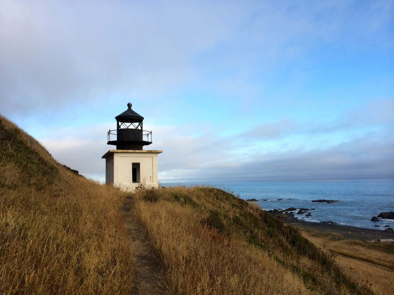
We continued on, and soon spied the famous Punta Gorda lighthouse. This historic light house was built in 1910 after a number of fatal shipwrecks on the rocks off the coast. It’s unique in that it’s on the mainland, and it’s short, squat lighthouse. It remained in operation until 1961, when new technology replaced the need for the lighthouse.

We were able to explore the lighthouse and climb up the rusty iron spiral staircase to the top. It’s in remarkably good condition even a century later.

The Punta Gorda Lighthouse is 3.75 miles from the Mattole trailhead, making it a great day hike destination for campers. Starting late in the day as we had, we say one other couple who were returning from the lighthouse. These would be the only two people we saw on the trail today.
The sun was dipping lower, and we were aiming to reach Sea Lion Gulch for our first night’s camp, about 1.25 miles further down the coast.
We found a campsite on the bluff overlooking the gulch.

Sea Lion Gulch is so-named because sea lions and seals frequent the rocks just off the coast. Indeed, there was a cranky old sea lion with is deep wails and the barks of the seals to confirm that we had arrived.
Our campsite gave us a great view down the coast. The next four miles of the trail were impassable at high tide, so by starting here, we could time our entry as the tide was receding and make sure we didn’t get caught by the incoming tide.
Lost Coast Trail: Day One Map
Day One of the Lost Coast: Photo Gallery
Click on any photo to view a larger version. You can also leave comments on any photo.


Lost Coast Trail Tips
- You can camp anywhere on the Lost Coast, but use previously established campsites whenever possible, to minimize impact on the environment.
- Carry a tide chart and know where the impassable sections are! While in those sections, keep an eye on the ocean. A rogue wave can sneak up at any time, and unsuspecting hikers have been swept out to sea.
- There is zero cell phone reception on the Lost Coast Trail. You’ll have to use backcountry smarts to handle any emergency that arises. Of course, you’re carrying the Ten Essentials, right?
- Be sure to start at the beginning, with our Overview of the Lost Coast Trail.
- We didn’t have any rain on our trip (July is historic a low-rainfall on this otherwise very wet trail). Even so, we had to use our rain fly every night. Anything that wasn’t covered got soaked with condensation from the fog. So cover up!
Our first day on the Lost Coast was memorable. We felt the solitude of the trail, and the beauty and history of this rugged coastline. We drifted to sleep serenaded by the waves crashing on the rocks below.
Next, read Day 2 on the Lost Coast Trail: Sea Lion Gulch to Spanish Flat.
Shelter Cove Weather Forecast
[forecast width=”100%” location=”95589“]
 Overview of the Lost Coast Trail
- Day 1: Mattole Beach to Sea Lion Gulch You are here!
- Day 2: Sea Lion Gulch to Spanish Flat
- Day 3: Spanish Flat to Miller Flat
- Day 4: Miller Flat to Shelter Cove

You must be logged in to post a comment.