• COVID-19 Park and Trail Closures
  • Learn about the Six-Pack of Peaks Challenge
  • Shop
  •  

SoCal Hiker

  • Find a Hiking Trail
    • All Areas
    • Arizona
    • Colorado
    • Los Angeles
    • Orange County
    • Oregon
    • San Francisco Bay
    • Washington
  • Trail Guides
  • Six-Pack of Peaks
    • Colorado Six-Pack of Peaks
      • Bergen Peak
      • Rocky Mountain
      • Birthday Peak
      • Horseshoe Mountain
      • Grays Peak
    • New England Six-Pack of Peaks
    • NorCal Six-Pack of Peaks
      • Mount Umunhum
      • Mount Saint Helena
      • Mount Tamalpais
      • Mount Diablo
      • Mount Sizer
      • Rose Peak
    • Oregon Six-Pack of Peaks
      • Tumalo Mountain
      • Black Butte
      • Black Crater
      • Maiden Peak
      • Mount Bachelor
      • South Sister
    • SoCal Six-Pack of Peaks
      • Mt. Wilson
      • Cucamonga Peak
      • Mt. San Antonio (Mt Baldy)
      • San Bernardino Peak
      • San Jacinto Peak
      • San Gorgonio
  • Backpacking
    • High Sierra Trail
    • John Muir Trail
      • Overview of the John Muir Trail
      • Training
      • Day-by-Day Itinerary
      • Resupply Addresses
      • JMT Discussion Forum
    • Lost Coast Trail
    • North/South Lake Loop
    • Rae Lakes Loop
    • Red Peak Pass Loop
    • Theodore Solomons Trail
    • Trans-Catalina Trail
    • Wonderland Trail
  • Gear
  • Forums
    • Latest Topics
    • Ask a Question
    • Campfire
    • Trails
    • Trail Reports
    • Gear Wisdom
    • Classifieds
  • Login

Memorial Weekend in Yosemite

June 1, 2010 By Jeff H 1 Comment

Over the Memorial Day weekend, Joan and I met up some new outdoor friends to go camping and hiking in Yosemite National Park. Jeff A., our third partner in our upcoming John Muir Trail adventure, introduced us to a terrific group.

I had never attempted to visit a national park on Memorial Day weekend, but it turns out to be a sort of unofficial start to the summer season. Yes, I would do it again if the opportunity came up. And yes, I would pick a different weekend if given a choice (it was crowded… more on that later).

Gear for four

The twelve of us had two campsites in the Upper Pines campground. We left Orange County at 6am on Saturday morning, reached the park entrance at 11:30am, and were waved right through without paying. That seemed odd until we left on Monday afternoon, and they collected our $20 entrance fee upon exiting. Apparently they sometimes wave people through to minimize traffic backups on entrance, and instead collect the fees when you exit.

I slept under the stars

I slept beneath the stars

The drive from the south entrance to the valley is about 40 miles, but once we hit the valley, traffic ground to a halt. We didn’t reach the campground until 1:30pm. We claimed our sleeping space and unloaded the gear, taking care to empty the Xterra of anything that had any scent (gum, toothpaste, and food, of course). With everything safely locked in the bear boxes, we put on our boots and prepared to hike.

Our original plan was to hike the Upper Yosemite Falls trail to Yosemite Point on Saturday afternoon, and then on Sunday, hike the Four Mile Trail to Glacier Point, then back down to the valley via the Panorama Trail. Unfortunately, the Four Mile Trail was still closed due to snow and ice, which the ranger station confirmed on Friday. Some of the group had permits to hike up Half Dome on Monday, but the cables were not up (and in fact, the NPS web site says two weeks before they’ll be up). So we had to be flexible and adjust our plans.

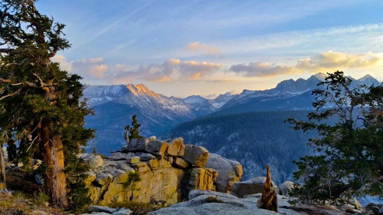
By the time we headed out, it was 3pm — a little late for the Upper Yosemite Falls trail — so we opted instead to hike the Mist Trail to the top of Nevada Falls, then loop down via the John Muir Trail back to Happy Isles. This is a fantastic, scenic hike most any time, but with this year’s above-average snowfall, the waterfalls were really spectacular. I’ll post a detailed trail report later this week, but suffice to say this is a great hike that’s well worth doing, even with the crowds.

Pint glasses for the locals

Afterwards, we fought the crowds at Curry Village and somehow managed to grab a couple stools at the bar for a well-earned cold ale and a hot pizza. We met the locals — the employees who often end their day here — including Larry the Baker and Jarod the Carpenter (it was his 15th season working in Yosemite). Jarod explained that there are about 2,200 employees living in the valley, and this weekend is the busiest of the year with about 25,000 people in Yosemite. At times it looked like most of them were sitting in their cars.

Traffic at a standstill

On Sunday, we headed out about 9am and took the shuttle to Yosemite Village. We found the Wilderness Center where we will pickup our JMT permits the day before our big trip, and walked to Yosemite Falls.

I’ve been to Yosemite six or seven times, but I have never seen so much water flowing through the falls. Most of the times I’ve been there in the past were later in the summer when the creek starts drying up. This was very different. And spectacular.

Our Sunday hike was the steep Upper Yosemite Falls trail, which gains nearly 2,700 feet of elevation in 3.2 miles and another 300 feet over 0.9 miles to Yosemite Point. Another terrific hike that I’ll write-up this week. Crowded, but worth doing at least once.

Monday, we drove up to scenic Glacier Point (the road had just opened the day before), soaked in the views, took some photos, and headed homeward. Getting out of the park wasn’t too bad, but we still hit stop-and-go traffic heading down the 5 that afternoon.

Many, many thanks to our outdoor friends, including Jeff A., Wendy, Tanya, Chhai, Carlos, Matt, Linda, Ramona and Wendy’s two friends (whose names I cannot recall). As true of most everyone I meet on the trail, everyone was really friendly and we all had a great time!

Photo Gallery

Click any thumbnail for a larger version. I’ve also posted a few highlights on Flickr and more people-oriented shots on Facebook.

Jeff & Joan at Glacier Point
Nevada Falls, Vernal Falls & Half Dome
Check out the snow banks at Glacier Point
Above Upper Yosemite Falls
The trail to Yosemite Point was still covered with snow
Approaching Vernal Falls
Getting wet on the JMT
Traffic at a standstill
Pint glasses for the Locals
Jeff A. on our way to Vernal Falls
Half Dome cables still down
I slept under the stars
Loaded
Yosemite Valley from Upper Yosemite Falls trail

Expert Advice

  • Do you use Twitter? Follow @YosemiteNPS. I sent out a tweet about the Four Mile Trail and got a response via Twitter within minutes!
  • One of the best unofficial resources I’ve found for hiking in Yosemite is YosemiteHikes.com. The provide great trail guides complete with maps and witty narrative. Highly recommended.

Filed Under: Hiking News Tagged With: camping, JMT Resources, trail, waterfall, Yosemite

Like what you found here at SoCal Hiker? This site is a labor of love. Share your support for the site and help us development of new trail guides and expanded coverage -- make your next outdoor equipment purchase through our advertisers.

You can also subscribe to our weekly newsletter and follow us on Facebook or Twitter.

Jeff H

About Jeff H

I'm an avid hiker and backpacker. My wife Joan and I are on the trails every weekend. I started SoCal Hiker to share my passion for outdoor adventure.

Comments

  1. Tyler (One With Nature) says

    August 23, 2010 at 11:51 am

    Yosemite on Memorial Weekend? Your nuts…. Thats Crazier than any of the free climbing i do. lol

    Reply

Leave a Reply Cancel reply

Your email address will not be published. Required fields are marked *

This site uses Akismet to reduce spam. Learn how your comment data is processed.

About SoCal Hiker

Jeff on Mount Rainier

I created SoCal Hiker while preparing to thru-hike the John Muir Trail. My goal? Create guides for the best hiking and backpacking trails with enough detail to make it an enjoyable experience for you. And while I started with trails in Southern California, I’ve expanded across the west. We hike each trail to create these guides, sharing practical advice on gear and outdoor skills. Read more…

Connect with SoCal Hiker

  • 22,751 Fans
  • 11,946 Followers
  • Followers
  • 1,717 Followers
  • 5,281 Subscribers
  • 342 Subscribers
SoCalHiker was selected one of USA TODAY's 10 Best Hiking and Outdoor Blogs
Get our day-by-day guide to thru-hiking the John Muir Trail
Get up-to-day wildfire status throughout California

Products

  • Quality, weather resistant and dishwasher safe SoCalHiker stickers. SoCal Hiker Stickers (2-pack) $3.50
  • Mt Baldy Mug Mt San Antonio (Mt Baldy) Mug $15.95
  • Mount San Jacinto T-Shirt $23.00 – $25.00
  • Cucamonga Peak Benchmark Cucamonga Peak Benchmark $39.95

Sponsors

Sponsor SoCalHiker and see your banner here

Featured Posts

Hiking Belknap Crater in the Mountain Washington Wilderness

Hiking this out-and-back route up Belknap Crater you'll traverse an other-worldly … [Read More...]

Hiking to the Simpson Reef Overlook on the Oregon Coast Trail

The Oregon Coast is rugged, beautiful and often uncrowded. This bluff-top … [Read More...]

Join Team SoCalHiker at the Climb for Heroes

Team SoCalHiker is climbing Mount Baldy again as part of the annual Climb for Heroes … [Read More...]

Lastest Comments

  • Amy Courtney on Ridgeline Trail
  • Jay Eleanor on Hiking to the Simpson Reef Overlook on the Oregon Coast Trail
  • Charles Krim on Hiking to the Simpson Reef Overlook on the Oregon Coast Trail
  • 11 Best California Bikepacking Routes | Wild Lumens on Inside Crystal Cove State Park
  • Ted Thed on Burbank Peak, Cahuenga Peak, Mt. Lee and the Hollywood Sign
Get your SoCalHiker stickers now

Get your SoCalHiker stickers!

Latest Posts

  • Hiking Belknap Crater in the Mountain Washington Wilderness October 20, 2022
  • Hiking to the Simpson Reef Overlook on the Oregon Coast Trail August 25, 2022
  • Join Team SoCalHiker at the Climb for Heroes August 23, 2022
  • Hiking the Welch-Dickey Loop in the White Mountain National Forest August 18, 2022
  • Hiking Turtlehead Peak from Red Rock Canyon National Conservation Area July 15, 2022

Recent Forum Topics

  • How to deal with accidents while hiking in the winter?
  • Warm Tips for your hiking in winter
  • Some tips for hiking.
  • Keep your body warm in the winter hiking
  • The benefits of hiking, more than you can imagine!

The Six-Pack of Peaks Challenge Series

Six-Pack of Peaks Challenge SeriesThe Six-Pack of Peaks Challenge Series gives you an opportunity to explore your world while supporting a great cause. There are eleven challenges around the country. Hike or run them at your own schedule.

Flex your adventure muscles!

Learn more here.


Search

Tags

3-6 miles 6-8 miles 8-10 miles 11+ miles Arizona Backpacking coastal dog-friendly easy family-friendly High Sierra Trail hiking Hiking The John Muir Trail hipster inspiration JMT John Muir John Muir Trail Kings Canyon National Park LA County moderate Mount Rainier National Park Muir Monday National Park Orange County Oregon out of bounds Pacific Crest Trail peak peakbagging quote scenic Sequoia National Park Sierra Nevada Six-Pack of Peaks State Park strenuous Thru-hiking Utah vista Washington waterfall wilderness Wonderland Trail Yosemite

Copyright © 2023 SoCalHiker.net · Metro Theme on Genesis Framework with WPEngine Hosting · Contact SoCal Hiker · Sitemap · Privacy Policy


Loading Comments...