• COVID-19 Park and Trail Closures
  • Learn about the Six-Pack of Peaks Challenge
  • Shop
  •  

SoCal Hiker

  • Find a Hiking Trail
    • All Areas
    • Arizona
    • Colorado
    • Los Angeles
    • Orange County
    • Oregon
    • San Francisco Bay
    • Washington
  • Trail Guides
  • Six-Pack of Peaks
    • Colorado Six-Pack of Peaks
      • Bergen Peak
      • Rocky Mountain
      • Birthday Peak
      • Horseshoe Mountain
      • Grays Peak
    • New England Six-Pack of Peaks
    • NorCal Six-Pack of Peaks
      • Mount Umunhum
      • Mount Saint Helena
      • Mount Tamalpais
      • Mount Diablo
      • Mount Sizer
      • Rose Peak
    • Oregon Six-Pack of Peaks
      • Tumalo Mountain
      • Black Butte
      • Black Crater
      • Maiden Peak
      • Mount Bachelor
      • South Sister
    • SoCal Six-Pack of Peaks
      • Mt. Wilson
      • Cucamonga Peak
      • Mt. San Antonio (Mt Baldy)
      • San Bernardino Peak
      • San Jacinto Peak
      • San Gorgonio
  • Backpacking
    • High Sierra Trail
    • John Muir Trail
      • Overview of the John Muir Trail
      • Training
      • Day-by-Day Itinerary
      • Resupply Addresses
      • JMT Discussion Forum
    • Lost Coast Trail
    • North/South Lake Loop
    • Rae Lakes Loop
    • Red Peak Pass Loop
    • Theodore Solomons Trail
    • Trans-Catalina Trail
    • Wonderland Trail
  • Gear
  • Forums
    • Latest Topics
    • Ask a Question
    • Campfire
    • Trails
    • Trail Reports
    • Gear Wisdom
    • Classifieds
  • Login

Hiking to Strawberry Peak

January 18, 2019 By CeCe Lorthioir 10 Comments

Views from Strawberry Peak

At 6,165 feet, Strawberry Peak is the highest summit in the front range of the San Gabriel Mountains, a mere 3 feet taller than its neighbor, San Gabriel Peak. This area was heavily damaged and was closed after the Station Fire in 2009, but was re-opened in 2014.

Strawberry Peak name was given by mountaineers over a century ago because of its peak’s likeness to an enormous upside-down strawberry fruit.

During clear days, Strawberry Peak can be seen as a round bump behind San Gabriel Peak and Mount Wilson, usually visible from the LA basin.

img
Trail Details
Summit: 6,165′
Distance: 7.5 miles
Time: 4-5 hours
Difficulty: Strenuous
Elevation gain (loss): 2,609 ft
Dogs: No
When to go: Year-round (weather dependent)
Though it is a short in/out hike, it is also a challenging one, crossing three different “false peaks” and requires a slightly technical climb with a bit of rock scrambling to reach its Peak.

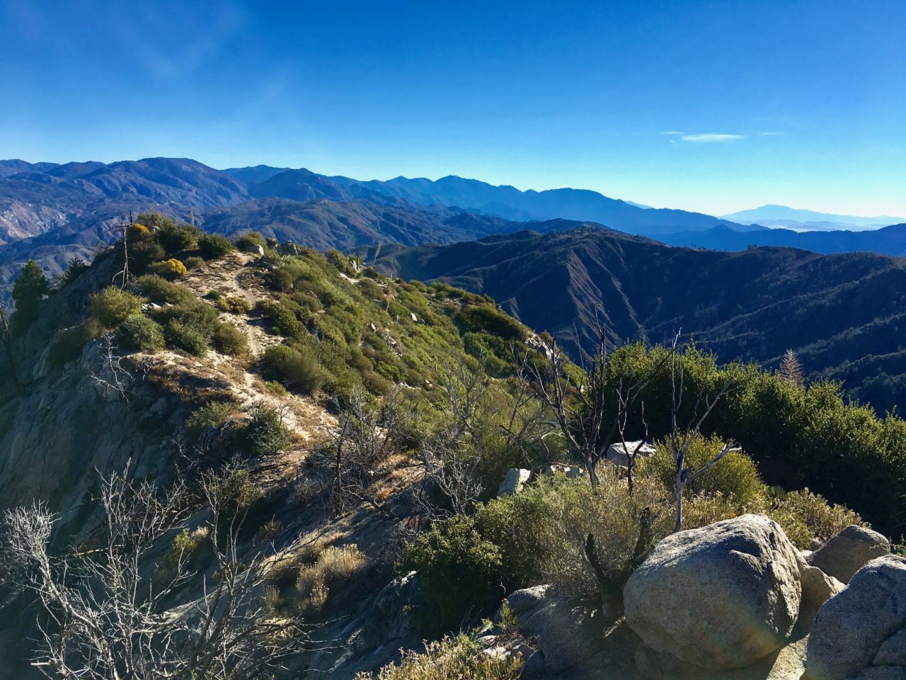
Hikers are rewarded with excellent views of the San Gabriel and Santa Monica Mountains, and beyond to Los Angeles and Glendale skylines.

Getting to Trailhead

Red Box Picnic Area is easy to reach. It is 14 miles up along the Angeles Crest Highway (Highway 2) from La Canada Flintridge, at the intersection of Mount Wilson Red Box Road. The picnic area has a large parking lot with a public restroom. An Adventure Pass is required to park.

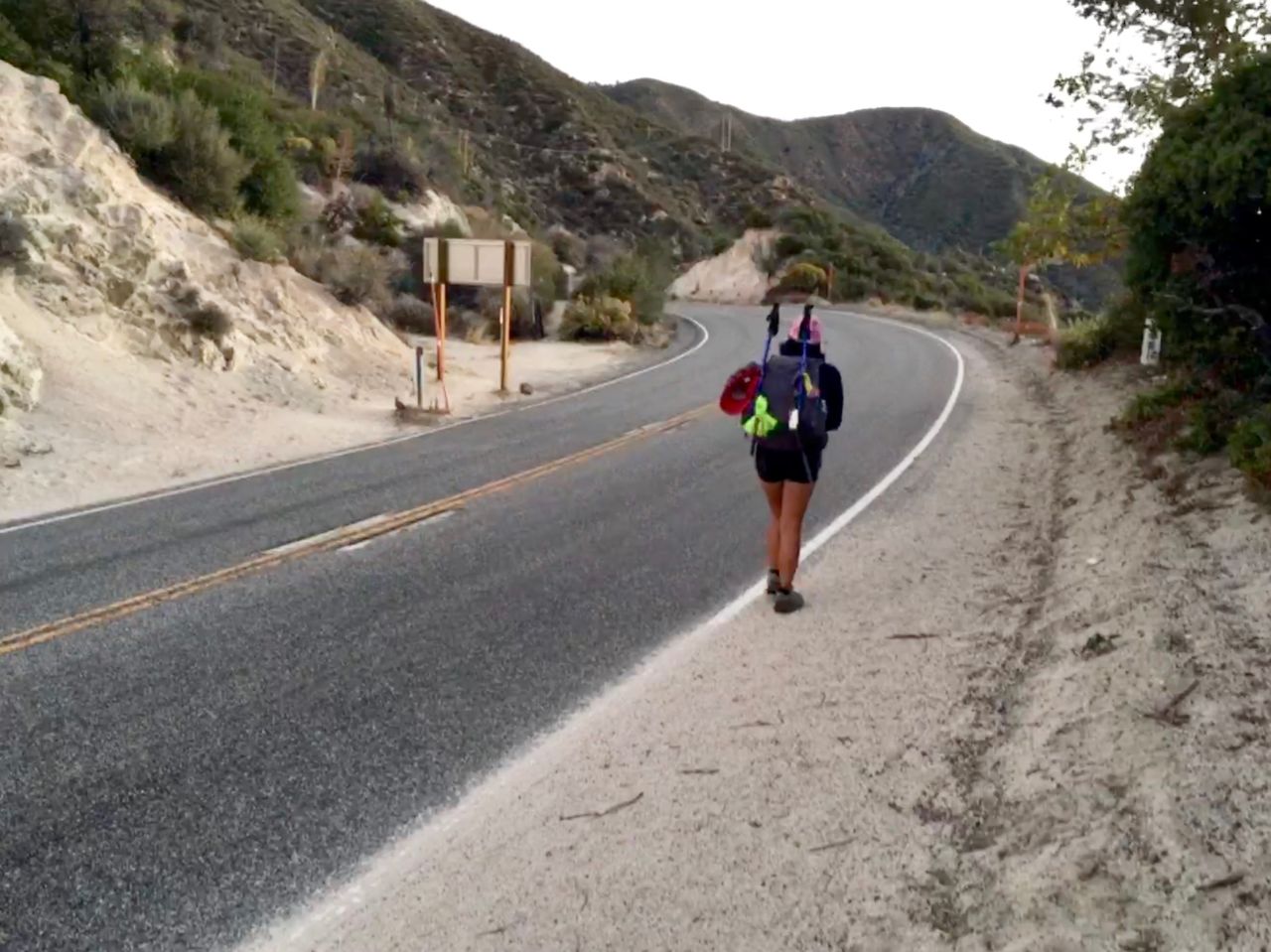
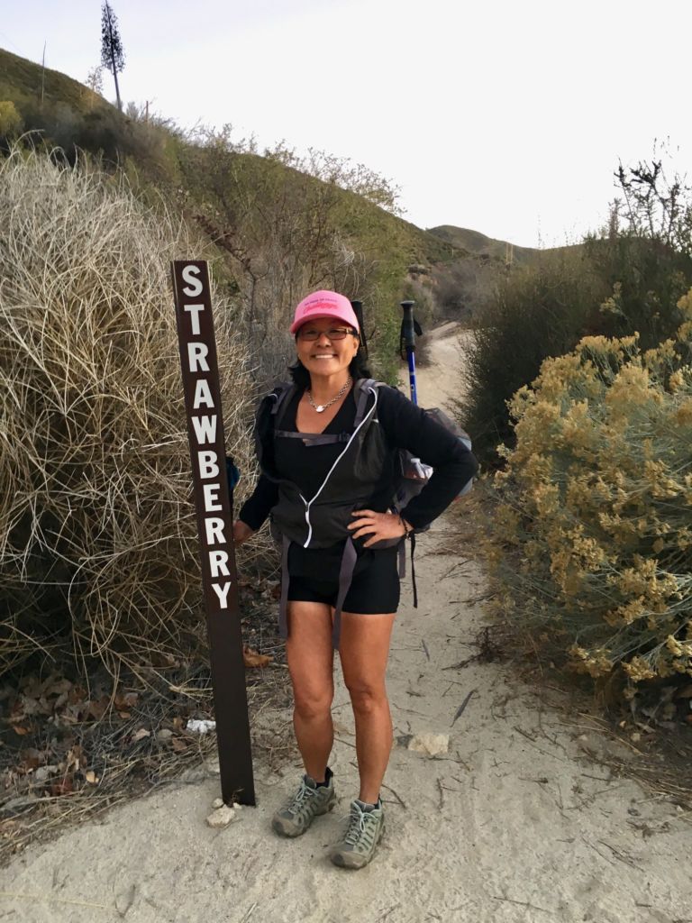
To get to Strawberry Peak trailhead, VERY carefully cross Highway 2 from parking lot. The trailhead is marked with a wood post announcing the Strawberry Peak Trail.

CeCe and Meredith at the Red Box parking lot
Highway 2
Hiking Strawberry Peak
Marker for the Strawberry Peak Trail

Hiking the Trail to Strawberry Peak

The hike starts easily enough on a single-track dirt trail lined with oak trees and ascends gradually and continues up the ridge above Highway 2. Power lines run along this early portion of the trail, but rest assured, it ends as you go further up.

The Strawberry Peak trail begins

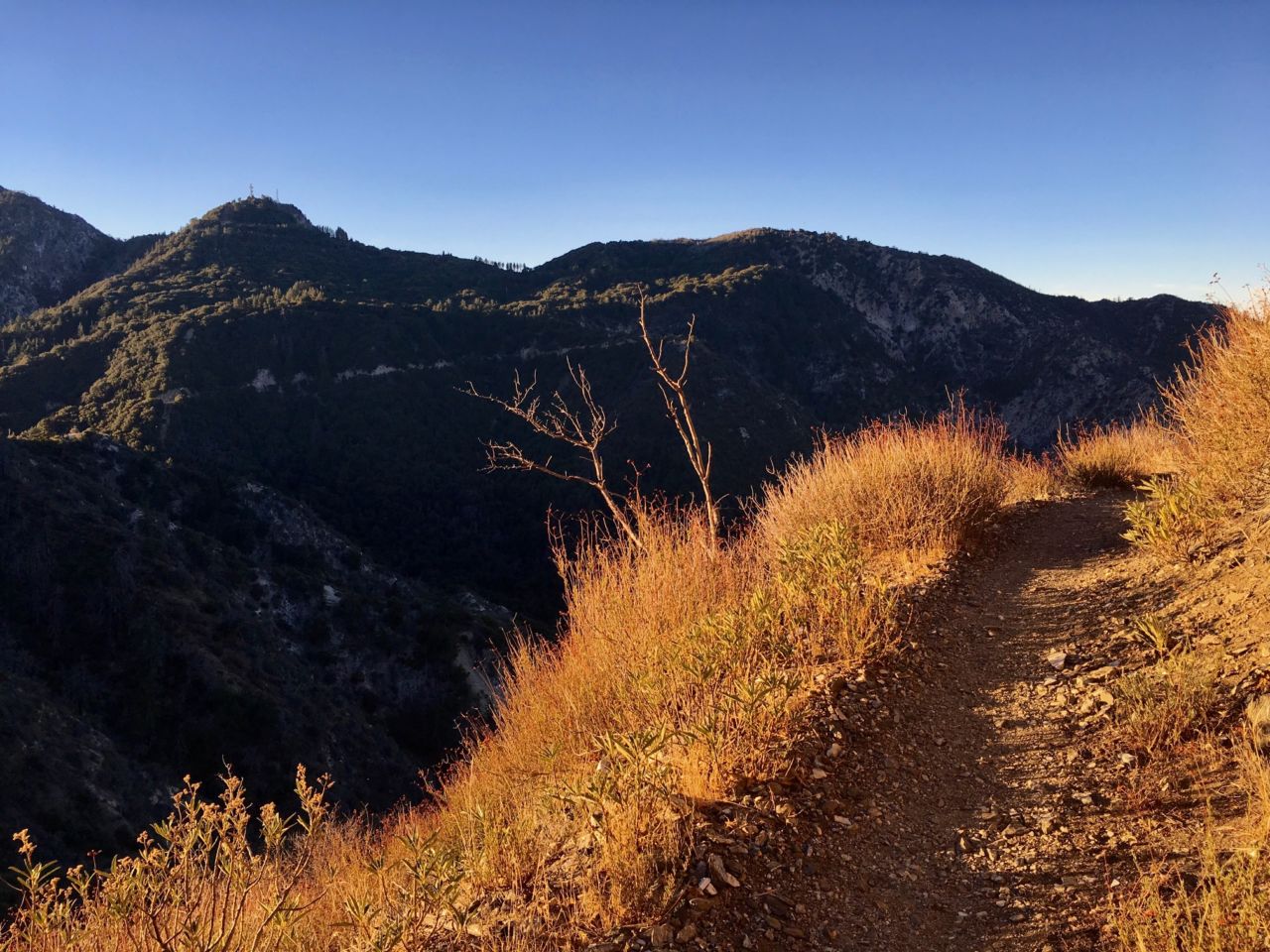
Continue hiking up to 0.9 miles to a sharp switchback heading west, with Mount Lawlor rising just above you. The trail continues to ascend gradually, with occasional downhill stretches which are not bad. At mile 2, you will look south with an excellent view of Mount Disappointment and San Gabriel Peak, and Mount Wilson to the west.

Strawberry Peak hike guide

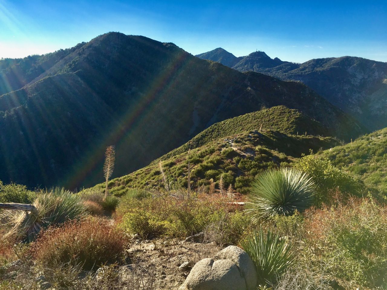
At this point, you will also have an intimidating view of the steep slope to Strawberry Peak. From here, you will hike downhill, dropping sharply to the Lawlor Saddle, losing some of the hard-earned gains. Once at the Lawlor Saddle, it is a good spot to rest and refuel before the technical climb to the peak.

Continue up the steep ridgeline

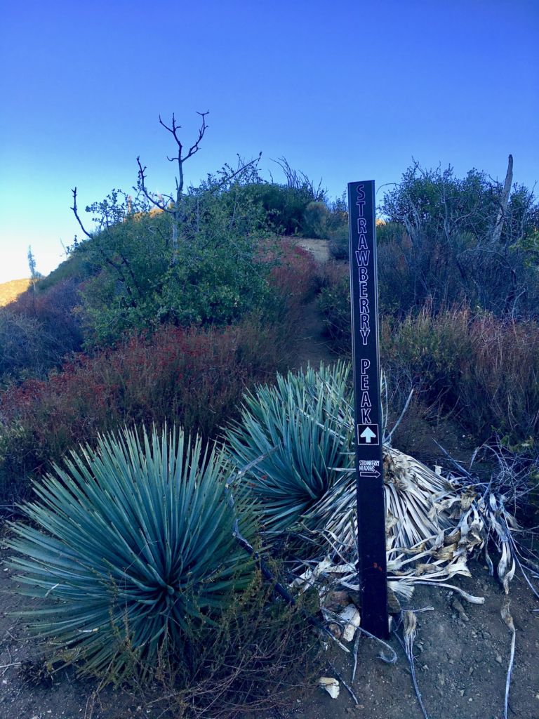
Mile 2.5 marks the beginning of the steep ascent to Strawberry Peak. Turn left, off Strawberry Peak Trail, leaving the comfort of the trail. (Although, it is tempting to continue on the right, towards Strawberry Meadow). At this point, the climb is relentless with some rock scrambles, and which you may occasionally use your hands to navigate big rocks.

Strawberry Peak Trail

Yucca, sage and low shrubs dominate the landscape in this part. As you climb, there will be two false peaks that follows the ridge line, and finally arriving on the real peak of Strawberry Peak.

The peak itself is a small bump, surrounded by low brush, and with spectacular views of the LA basin. Some hikers bring strawberries (if in season) as an homage for conquering its sweet summit.

Scrub and marker at the summit of Strawberry Peak
Strawberry Peak is part of the SoCal Six-Pack of Peaks Challenge
Meredith smiling on Strawberry Peak
Bring your own strawberries

After your summit selfies and celebratory strawberries, return to the Red Box parking area the same way you came.

Strawberry Peak Trail Map

© OpenStreetMap contributors
Download file: strawberry-peak-via-red-box.gpx

Tips & Resources for Hiking Strawberry Peak

  • Go early to get first dibs on parking. An Adventure Pass is required for parking.
  • There is a restroom at the parking lot area.
  • Avoid the Poodle-dog bush! Do NOT touch it! It is pretty to look at with purple flowers, but this can irritate skin and cause itching, rashes and blisters. Symptoms are very similar to poison oak. Wearing long pants is highly recommended.
  • Bring sun protection. Once above the tree line, you are fully exposed to the sun. This hike will be extremely hot during the summertime.
  • Carry at least 3 liters of hydration. There are no water sources here.
  • Strawberry Peak is part of the SoCal Six-Pack of Peaks Challenge supporting Big City Mountaineers.

Strawberry Peak Weather Forecast

The location could not be found.

Filed Under: Trail Guides Tagged With: 6-8 miles, California, San Gabriel Mountains National Monument, Six-Pack of Peaks, SoCal, Strawberry Peak, strenuous

Like what you found here at SoCal Hiker? This site is a labor of love. Share your support for the site and help us development of new trail guides and expanded coverage -- make your next outdoor equipment purchase through our advertisers.

You can also subscribe to our weekly newsletter and follow us on Facebook or Twitter.

CeCe L

About CeCe Lorthioir

In 2015, CeCe spontaneously organized a group of five to hike Mt. Baldy. That hike started Hike Beyond the Hills, which today has over 500 members. Since then, CeCe has lead yearly group hikes to successfully complete the Six-Pack of Peaks Challenge. Her mission as a hike leader is to build a community of responsible hikers who prioritize safety.

Comments

  1. David - Potty Adventures says

    January 22, 2019 at 12:34 pm

    This looks like a great hike with some lovely views.

    Reply
  2. Mandy EMandy E says

    February 5, 2019 at 12:34 pm

    If I was looking to camp near by for this hike, where would you recommend?

    Reply
  3. CeCe Lorthioir says

    February 5, 2019 at 3:19 pm

    Mandy:
    Though I never camped here, the closest campgrounds are Valley Forge and West Fork.
    https://www.fs.usda.gov/activity/angeles/recreation/camping-cabins/?recid=41672&actid=29

    Hope this helped.
    CeCe

    Reply
  4. Asen says

    February 24, 2019 at 4:21 am

    Hey Cece,

    Greetings from a fellow hiker and blogger from Bulgaria. We have some exciting trails here and I hope one day you will be able to come and see them. This is my blog gearuphiking.com. I’d love to connect with you.

    Strawberry peak looks like the perfect place for a nice hike.Quick question – is it kid-friendly?

    Keep up the great work, I love the websiteand your writing.

    Reply
  5. Lydia says

    February 25, 2019 at 7:33 pm

    Hello Cece, this is a nice article. I’l put this on my list when I’ll get to travel to the US. I think this is an exciting hike.

    Reply
  6. Ladakh tour package says

    April 3, 2019 at 3:21 am

    It seems you had a great experience hiking on strawberry peak. I loved the way you shared your own journey with us. Looking forward to hike on such place. Thanks for sharing.

    Reply
    • Antonio says

      January 29, 2020 at 3:27 pm

      What did you use to your elevation gain? I use a Garmin Fénix and my numbers are close to yours but most of the hiking sites list it at 1500- 1900 gain. Thanks AC

      Reply
  7. Brian Farris says

    August 13, 2019 at 12:26 pm

    2 cuties 1 mountain

    Reply
  8. Mikey says

    May 22, 2020 at 5:28 pm

    I loved the way you shared your own journey with us.

    Strawberry peak looks like the perfect place for a nice hike. Quick question – is it dog-friendly?

    Keep up the great work, I shared it in our social media for our audience.

    Reply
  9. fergus says

    May 31, 2021 at 4:02 pm

    i would say this hike is not kid friendly . I’ve seen people carrying their dog UP the trail . Poor dog , not trained for a hike like this . Regarding the hike … its BRUTAL . Saw people turning around on the first false peak . Wear proper hiking shoes, not tennis shoes . Bring water . If you think you have enough , you don’t . bring more . Wear a wide brimmed hat . Leave predawn !! DON’T LEAVE TRASH ! There is zero shade , and its very steep . Its super challenging IF you’re prepped. If you’re not , bring a garmin with a SOS feature.

    Reply

Leave a Reply Cancel reply

Your email address will not be published. Required fields are marked *

This site uses Akismet to reduce spam. Learn how your comment data is processed.

About SoCal Hiker

Jeff on Mount Rainier

I created SoCal Hiker while preparing to thru-hike the John Muir Trail. My goal? Create guides for the best hiking and backpacking trails with enough detail to make it an enjoyable experience for you. And while I started with trails in Southern California, I’ve expanded across the west. We hike each trail to create these guides, sharing practical advice on gear and outdoor skills. Read more…

Connect with SoCal Hiker

  • 22,757 Fans
  • 11,938 Followers
  • Followers
  • 1,719 Followers
  • 5,281 Subscribers
  • 341 Subscribers
SoCalHiker was selected one of USA TODAY's 10 Best Hiking and Outdoor Blogs
Get our day-by-day guide to thru-hiking the John Muir Trail
Get up-to-day wildfire status throughout California

Products

  • Mount Wilson T-Shirt $23.00 – $27.00
  • Let your SoCalHiker flag fly! SoCalHiker Red, White & Blue Summit Flag
    Rated 5.00 out of 5
    $25.00
  • Quality, weather resistant and dishwasher safe SoCalHiker stickers. SoCal Hiker Stickers (2-pack) $3.50
  • All The Paths Poster $22.00 – $130.00

Sponsors

Sponsor SoCalHiker and see your banner here

Featured Posts

Backpacking the Grand Canyon of Tuolumne Loop in Yosemite National Park

Yosemite National P ark, and in particular Yosemite Valley, is home to some of the … [Read More...]

Hiking Belknap Crater in the Mountain Washington Wilderness

Hiking this out-and-back route up Belknap Crater you'll traverse an other-worldly … [Read More...]

Hiking to the Simpson Reef Overlook on the Oregon Coast Trail

The Oregon Coast is rugged, beautiful and often uncrowded. This bluff-top … [Read More...]

Lastest Comments

  • Amy Courtney on Ridgeline Trail
  • Jay Eleanor on Hiking to the Simpson Reef Overlook on the Oregon Coast Trail
  • Charles Krim on Hiking to the Simpson Reef Overlook on the Oregon Coast Trail
  • 11 Best California Bikepacking Routes | Wild Lumens on Inside Crystal Cove State Park
  • Ted Thed on Burbank Peak, Cahuenga Peak, Mt. Lee and the Hollywood Sign
Get your SoCalHiker stickers now

Get your SoCalHiker stickers!

Latest Posts

  • Backpacking the Grand Canyon of Tuolumne Loop in Yosemite National Park March 24, 2023
  • Hiking Belknap Crater in the Mountain Washington Wilderness October 20, 2022
  • Hiking to the Simpson Reef Overlook on the Oregon Coast Trail August 25, 2022
  • Join Team SoCalHiker at the Climb for Heroes August 23, 2022
  • Hiking the Welch-Dickey Loop in the White Mountain National Forest August 18, 2022

Recent Forum Topics

  • Lost Coast Trail
  • How to deal with accidents while hiking in the winter?
  • Warm Tips for your hiking in winter
  • Some tips for hiking.
  • Keep your body warm in the winter hiking

The Six-Pack of Peaks Challenge Series

Six-Pack of Peaks Challenge SeriesThe Six-Pack of Peaks Challenge Series gives you an opportunity to explore your world while supporting a great cause. There are eleven challenges around the country. Hike or run them at your own schedule.

Flex your adventure muscles!

Learn more here.


Search

Tags

3-6 miles 6-8 miles 8-10 miles 11+ miles Arizona Backpacking coastal dog-friendly easy family-friendly High Sierra Trail hiking Hiking The John Muir Trail hipster inspiration JMT John Muir John Muir Trail Kings Canyon National Park LA County moderate Mount Rainier National Park Muir Monday National Park Orange County Oregon out of bounds Pacific Crest Trail peak peakbagging quote scenic Sequoia National Park Sierra Nevada Six-Pack of Peaks State Park strenuous Thru-hiking Utah vista Washington waterfall wilderness Wonderland Trail Yosemite

Copyright © 2023 SoCalHiker.net · Metro Theme on Genesis Framework with WPEngine Hosting · Contact SoCal Hiker · Sitemap · Privacy Policy


Loading Comments...