• COVID-19 Park and Trail Closures
  • Learn about the Six-Pack of Peaks Challenge
  • Shop
  •  

SoCal Hiker

  • Find a Hiking Trail
    • All Areas
    • Arizona
    • Colorado
    • Los Angeles
    • Orange County
    • Oregon
    • San Francisco Bay
    • Washington
  • Trail Guides
  • Six-Pack of Peaks
    • Colorado Six-Pack of Peaks
      • Bergen Peak
      • Rocky Mountain
      • Birthday Peak
      • Horseshoe Mountain
      • Grays Peak
    • New England Six-Pack of Peaks
    • NorCal Six-Pack of Peaks
      • Mount Umunhum
      • Mount Saint Helena
      • Mount Tamalpais
      • Mount Diablo
      • Mount Sizer
      • Rose Peak
    • Oregon Six-Pack of Peaks
      • Tumalo Mountain
      • Black Butte
      • Black Crater
      • Maiden Peak
      • Mount Bachelor
      • South Sister
    • SoCal Six-Pack of Peaks
      • Mt. Wilson
      • Cucamonga Peak
      • Mt. San Antonio (Mt Baldy)
      • San Bernardino Peak
      • San Jacinto Peak
      • San Gorgonio
  • Backpacking
    • High Sierra Trail
    • John Muir Trail
      • Overview of the John Muir Trail
      • Training
      • Day-by-Day Itinerary
      • Resupply Addresses
      • JMT Discussion Forum
    • Lost Coast Trail
    • North/South Lake Loop
    • Rae Lakes Loop
    • Red Peak Pass Loop
    • Theodore Solomons Trail
    • Trans-Catalina Trail
    • Wonderland Trail
  • Gear
  • Forums
    • Latest Topics
    • Ask a Question
    • Campfire
    • Trails
    • Trail Reports
    • Gear Wisdom
    • Classifieds
  • Login

Hiking to Kendrick Peak in the Kaibab National Forest

April 12, 2019 By Richard Oppelaar 2 Comments

Kendrick Peak Lookout Panorama

One of the tallest mountains in the San Francisco volcanic field, Kendrick Peak offers spectacular views stretching from Humphreys Peak to the Grand Canyon. The trail begins in a quintessential ponderosa pine forest, travels up through a decades old burn area, and passes by a century-old historic cabin. At the very top, enjoy the scenery from the fire lookout built in the 60’s, or have a picnic in the sun on the platform just below.

img
Trail Details
Summit Elev.: 10,418′
Distance: 9.4 miles
Time: 5-6 hours
Difficulty: Strenuous
Elevation gain: 2,851′
Dogs: Yes
When to go: Spring, Summer, Fall

Getting to the Kendrick Peak Trailhead

From Flagstaff, head north out of town on Hwy 180. Continue on 180 for ten miles beyond the turn for Arizona Snowbowl. After mile marker 232, and just before mile marker 233, turn left onto FS 193 – a dirt road with a cattle guard at the start. Go about 3.2 miles until it ends at a T intersection with FS 171. Go right on FS 171, and continue about 2 miles. Turn right onto FS 190, go up about half a mile and you’ll see the trailhead parking area on the right side.

The lot is dirt and all roads from Hwy 180 are unpaved, but regular passenger cars typically have no trouble accessing this trailhead. The start of the trail is located at the northeast corner of the lot. There are garbage cans and a pit toilet, but no running water.

Kendrick Peak Trailhead

Hiking Kendrick Peak

Take some time looking over the trailhead signage to get your bearings, and learn some history about fires and fire prevention in the Kendrick Mountain Wilderness. Ponder where the Pumpkin name comes from, then pass through the fence to start your hike. The trail begins broad and easy in a forest of ponderosa pines.

Kendrick Peak Trail Starts Gently

The path wraps around the southeast slope of East Newman Hill, then turns north with four quick switchbacks. Here you see increasing evidence of the 2000 Pumpkin Fire.

The 2000 Pumpkin Fire is still evident

Continue through the more severe burn area. Around the 1.5 mile mark the trail approaches the drainage dip one last time before switchbacking left. Without a noticeable increase in steepness, the trail climbs onto the southwest ridge of Kendrick Peak.

Climbing the southwest ridge of Kendrick Peak

Once you are on the ridge, this is a nice place to take a break. It’s about the 2 mile mark, and the area is a broad flat shoulder with good spots to park it. After some noshing and sipping, continue switchbacking up the ridge. Somewhere around the eighth or ninth switchback, the trail takes a conifer respite and gives you some birch tree action.

Birch trees on Kendrick Mountain

The trail gradually moves east until the 3 mile mark where it crosses the south ridge, continues moving up the southeast side of the mountain, and switchbacks up to the expansive flat just east of the peak. A little beyond the 4 mile mark you will find an old cabin. Built in 1912, this cabin was saved from the Pumpkin Fire by fire fighters who wrapped the structure in fire resistant material.

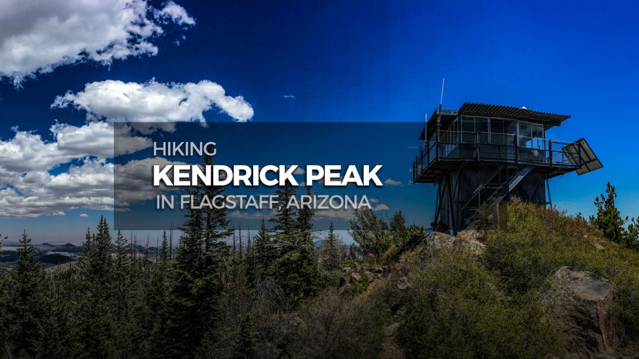
After imagining the cabin wrapped up like a giant baked potato, continue west on the path toward the peak. There’s a sign along the trail after the cabin that says “Kendrick Lookout”, and about a half mile after that you reach the top of Kendrick Peak!

Panoramic view from Kendrick Peak

To the east is Humphreys Peak, and if you look to the north on a clear day you can easily see the Grand Canyon. There’s a fire lookout at the true summit, and a nice platform on the west side of the peak perfect for a summit picnic.

Picnic platform on the west side of Kendrick Peak

When your eyeballs have had their fill of the view, return down the same way you came up.

Kendrick Peak Trail
Kendrick Mountain Wilderness

Kendrick Peak Trail Map & Elevation Profile

© OpenStreetMap contributors
Download file: Kendrick_Peak_Arizona.gpx

Kendrick Peak Resources

  • Forest Service’s web pages with info on the Kendrick Mountain Trail.


Arizona Summer Six-Pack of Peaks Challenge

Arizona Six-Pack of Peaks Challenge – Summer Edition

This hike is part of the Arizona Six-Pack of Peaks Challenge – Summer Edition. This self-paced hiking challenge includes six hikes all easily reached from the Flagstaff/Sedona area. They are a great way to explore the area, train for bigger adventures, and you’ll be doing good, with a portion of the net proceeds going to support Big City Mountaineers.

Registration for the summer challenge runs between April 1 and September 15.  Be sure to check out the winter challenge, too!

Filed Under: Trail Guides Tagged With: 8-10 miles, Arizona, dog-friendly, Flagstaff, Kaibab National Forest, Kendrick Peak, peak, peakbagging, Six-Pack of Peaks

Like what you found here at SoCal Hiker? This site is a labor of love. Share your support for the site and help us development of new trail guides and expanded coverage -- make your next outdoor equipment purchase through our advertisers.

You can also subscribe to our weekly newsletter and follow us on Facebook or Twitter.

Richard O

About Richard Oppelaar

To me, hiking is a way to see the country in ways many people don’t. Road trips and collecting high points are my main motive. I grew up in New Jersey, discovered hiking while living in North Carolina, and have been based in Southern California since 2012. I love everything from hiking well maintained, popular trails in the Southwest to mountaineering less accessible peaks. My day job is teaching at a school where I’m lucky enough to have a small hiking club for students who I take on small excursions once a month.

Comments

  1. Chris says

    June 27, 2019 at 1:14 am

    The images make me feel crazy and I thought I should come there as soon as possible. I will ask my friend too because he is a good hiker. Thanks for sharing this place

    Reply
  2. Hobo Hammocks says

    June 28, 2019 at 12:50 am

    This is very helpful especially to those who plan on setting aside a weekend to hike the Kendrick Peak Trail with friends or family. The level of difficulty lets us know in advance if we are indeed capable of making that 5-6 hours hike.

    Reply

Leave a Reply Cancel reply

Your email address will not be published. Required fields are marked *

This site uses Akismet to reduce spam. Learn how your comment data is processed.

About SoCal Hiker

Jeff on Mount Rainier

I created SoCal Hiker while preparing to thru-hike the John Muir Trail. My goal? Create guides for the best hiking and backpacking trails with enough detail to make it an enjoyable experience for you. And while I started with trails in Southern California, I’ve expanded across the west. We hike each trail to create these guides, sharing practical advice on gear and outdoor skills. Read more…

Connect with SoCal Hiker

  • 22,754 Fans
  • 11,943 Followers
  • 21,640 Followers
  • 1,716 Followers
  • 5,279 Subscribers
  • 339 Subscribers
SoCalHiker was selected one of USA TODAY's 10 Best Hiking and Outdoor Blogs
Get our day-by-day guide to thru-hiking the John Muir Trail
Get up-to-day wildfire status throughout California

Products

  • 2015 Six-Pack of Peaks patch 2015 Six-Pack of Peaks Patch $5.00
  • South Sister Benchmark South Sister Benchmark $39.95
  • 2017 Six-Pack of Peaks Sticker 2017 Six-Pack of Peaks Sticker $3.00
  • Mt Baldy Mug Mt San Antonio (Mt Baldy) Mug $15.95

Sponsors

Sponsor SoCalHiker and see your banner here

Featured Posts

Hiking Belknap Crater in the Mountain Washington Wilderness

Hiking this out-and-back route up Belknap Crater you'll traverse an other-worldly … [Read More...]

Hiking to the Simpson Reef Overlook on the Oregon Coast Trail

The Oregon Coast is rugged, beautiful and often uncrowded. This bluff-top … [Read More...]

Join Team SoCalHiker at the Climb for Heroes

Team SoCalHiker is climbing Mount Baldy again as part of the annual Climb for Heroes … [Read More...]

Lastest Comments

  • Greg on Rae Lakes Loop via Kearsarge Pass
  • Tim Wilson on Rae Lakes Loop via Kearsarge Pass
  • Pam Selthun on Backpacking the Wonderland Trail
  • Calico Maps on Hiking Monserate Mountain
  • Deborah Aguanno on Mt. Wilson via Chantry Flats
Get your SoCalHiker stickers now

Get your SoCalHiker stickers!

Latest Posts

  • Hiking Belknap Crater in the Mountain Washington Wilderness October 20, 2022
  • Hiking to the Simpson Reef Overlook on the Oregon Coast Trail August 25, 2022
  • Join Team SoCalHiker at the Climb for Heroes August 23, 2022
  • Hiking the Welch-Dickey Loop in the White Mountain National Forest August 18, 2022
  • Hiking Turtlehead Peak from Red Rock Canyon National Conservation Area July 15, 2022

Recent Forum Topics

  • How to deal with accidents while hiking in the winter?
  • Warm Tips for your hiking in winter
  • Some tips for hiking.
  • Keep your body warm in the winter hiking
  • The benefits of hiking, more than you can imagine!

The Six-Pack of Peaks Challenge Series

Six-Pack of Peaks Challenge SeriesThe Six-Pack of Peaks Challenge Series gives you an opportunity to explore your world while supporting a great cause. There are eleven challenges around the country. Hike or run them at your own schedule.

Flex your adventure muscles!

Learn more here.


Search

Tags

3-6 miles 6-8 miles 8-10 miles 11+ miles Arizona Backpacking coastal dog-friendly easy family-friendly High Sierra Trail hiking Hiking The John Muir Trail hipster inspiration JMT John Muir John Muir Trail Kings Canyon National Park LA County moderate Mount Rainier National Park Muir Monday National Park Orange County Oregon out of bounds Pacific Crest Trail peak peakbagging quote scenic Sequoia National Park Sierra Nevada Six-Pack of Peaks State Park strenuous Thru-hiking Utah vista Washington waterfall wilderness Wonderland Trail Yosemite

Copyright © 2023 SoCalHiker.net · Metro Theme on Genesis Framework with WPEngine Hosting · Contact SoCal Hiker · Sitemap · Privacy Policy


Loading Comments...