• COVID-19 Park and Trail Closures
  • Learn about the Six-Pack of Peaks Challenge
  • Shop
  •  

SoCal Hiker

  • Find a Hiking Trail
    • All Areas
    • Arizona
    • Colorado
    • Los Angeles
    • Orange County
    • Oregon
    • San Francisco Bay
    • Washington
  • Trail Guides
  • Six-Pack of Peaks
    • Colorado Six-Pack of Peaks
      • Bergen Peak
      • Rocky Mountain
      • Birthday Peak
      • Horseshoe Mountain
      • Grays Peak
    • New England Six-Pack of Peaks
    • NorCal Six-Pack of Peaks
      • Mount Umunhum
      • Mount Saint Helena
      • Mount Tamalpais
      • Mount Diablo
      • Mount Sizer
      • Rose Peak
    • Oregon Six-Pack of Peaks
      • Tumalo Mountain
      • Black Butte
      • Black Crater
      • Maiden Peak
      • Mount Bachelor
      • South Sister
    • SoCal Six-Pack of Peaks
      • Mt. Wilson
      • Cucamonga Peak
      • Mt. San Antonio (Mt Baldy)
      • San Bernardino Peak
      • San Jacinto Peak
      • San Gorgonio
  • Backpacking
    • High Sierra Trail
    • John Muir Trail
      • Overview of the John Muir Trail
      • Training
      • Day-by-Day Itinerary
      • Resupply Addresses
      • JMT Discussion Forum
    • Lost Coast Trail
    • North/South Lake Loop
    • Rae Lakes Loop
    • Red Peak Pass Loop
    • Theodore Solomons Trail
    • Trans-Catalina Trail
    • Wonderland Trail
  • Gear
  • Forums
    • Latest Topics
    • Ask a Question
    • Campfire
    • Trails
    • Trail Reports
    • Gear Wisdom
    • Classifieds
  • Login

Hiking to Colchuck Lake in the Alpine Lakes Wilderness

October 26, 2018 By Jeff Hester 2 Comments

Colchuck Lake Panorama

Colchuck Lake is truly a gem of a day hike. It is the bigger brother to the nearby Enchantment Lakes, much easier to reach (as a day hike, especially), and some have described it as a religious experience. The glacier-fed waters of Colchuck Lake are an ethereal aquamarine blue. The jagged peaks and passes surrounding the lake have mystical names like Dragontail and Aasgard Pass. It’s a magical hike and a great way to whet your appetite for further adventures in this area near Leavenworth.

Trail Details
Colchuck Lake: 5,570′
Distance: 8.8 miles
Time: 5 hours
Difficulty: Strenuous
Elevation gain: 2,392 ft
Dogs: No
When to go: June-October

Getting to the Trailhead

From the Bavarian-themed town of Leavenworth, head west on Highway 2 for about two miles, then turn left onto Icicle Road. Follow Icicle Road for 8.5 miles, turning left onto NF-7600. You’ll follow this forest service road for 3.7 miles to the trailhead parking area. Get turn-by-turn driving directions via Google Maps.

There is room for about 30 cars here and it still fills up. We had plenty of parking when we arrived, but it was pretty full by the time we finished our hike, even on a mid-week day after Labor Day. The key here is to start early. There are pit toilets at the trailhead as well as a picnic table. A Northwest Forest Pass or Interagency Pass (like a National Parks Annual Pass) is required to park at the trailhead. Permits for day hikes are self-issued at the trailhead, but permits for overnight trips must be obtained in advance.

Note that the Forest Service road from Icicle Road to the trailhead closes in winter, typically November to May due to snow.

Hiking to Colchuck Lake

The trail begins with a gentle, forested climb that follows the beautiful cascades of Mountaineer Creek.

Mountaineer Creek

After about 1.25 miles, you reach a footbridge and the climb begins to get serious.

Entering the Alpine Lakes Wilderness
Crossing one of the footbridges en route to Colchuck Lake

Beautiful clear waters of Mountaineer Creek

Another mile up the trail and you reach a junction with the trail to Lake Stuart. Take the left branch pointing to Colchuck Lake, and you will see an improvised log bridge at the base of a boulder field.

Lake Stuart - Colchuck Lake Junction
Log bridge at boulder field

Once you’ve crossed this second bridge, the trail picks its way along the base of the boulder field for about 20 yards before resuming a more typical dirt and rock trail. From here, the trail leaves Mountaineer Creek and begins to climb up the canyon wall.

Crossing a creek en route to Colchuck Lake

No campfires above 5000 feet
A rock outcrop on the Colchuck Lake trail

This section of the trail has some steep parts, but it’s well engineered, well maintained and easy to follow. As you climb higher up the canyon wall, you begin to catch glimpses of the views that await you.

Stone steps on the climb to Colchuck Lake

As the trail nears Colchuck Lake, you’ll see a sign to a pit toilet. It’s the only one here, and there are no walls. It’s truly a throne with a view! But please, if you need to answer the call of nature, use this pit toilet. Because of the popularity of this hike, human waste can become a real problem. Don’t be part of that problem.

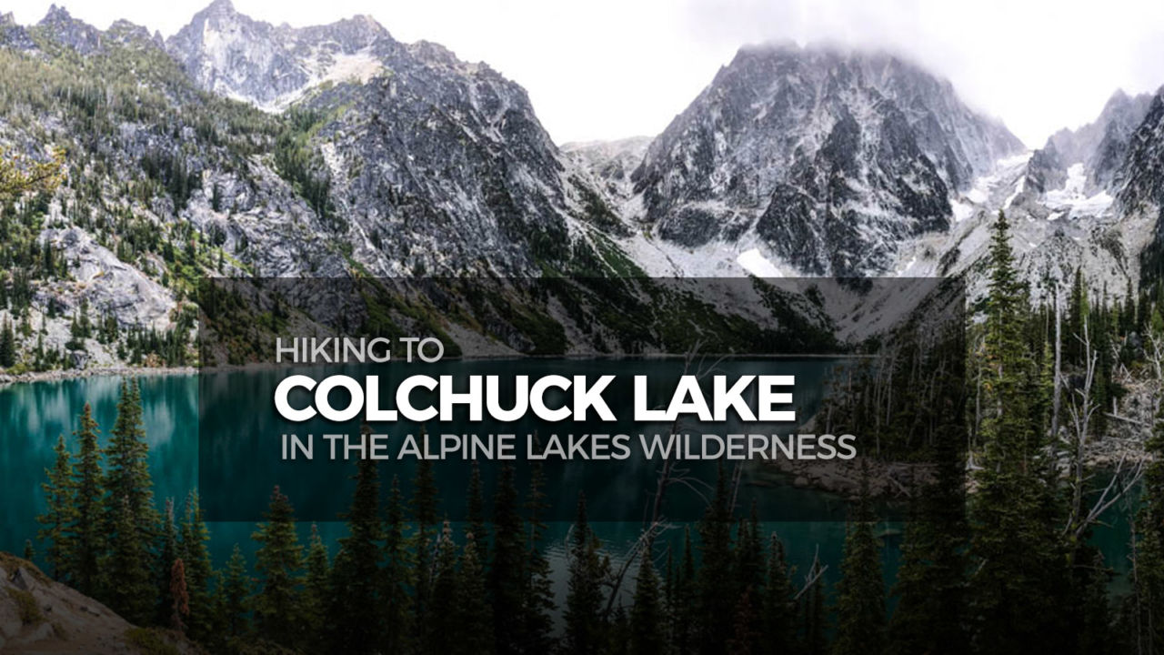
And then… like magic, the blue waters of Colchuck Lake appear through the trees! The trail continues around the west side of the lake. Hike on to find a good spot to sit and soak in the views of the glacier-blue water. Craggy Dragontail Peak lies directly across from you, with Aasgard Pass to the left of that. From this vantage point, it’s difficult to imagine that there’s actually a trail headed up there, leading to the Enchantment Lakes.

Colchuck Lake and Dragontail Peak

Jeff & Joan at Colchuck Lake
Colchuck Lake Panorama

We had a blustery, cloudy day for our hike, but just a touch of sunlight makes colorful Colchuck Lake come alive.

Explore the area of Colchuck Lake, and then return via the same route you came. Some sites list the mileage as under 8 miles for the total hike, but we logged a total of 8.8 miles on GaiaGPS.

Colchuck Lake Trail Map & Elevation Profile

© OpenStreetMap contributors
Download

Colchuck Lake Tips & Hiking Resources

  • Overview of Colchuck Lake via WTA.org
  • Get turn-by-turn driving directions to the trailhead via Google Maps
  • Bring plenty of water. You’ll want at least one liter or more. You can replenish water in the creeks or lake, but be sure to filter or treat before drinking.
  • Bring the 10 essentials.
  • Practice the seven Leave No Trace principles.
  • Stop in Leavenworth after your hike! There are some great restaurants and pubs.

Colchuck Lake Weather Forecast

The location could not be found.

Originally hiked on September 13, 2018 with Joan.

Related

Filed Under: Trail Guides Tagged With: 8-10 miles, Alpine Lakes Wilderness, Colchuck Lake, PNW, Six-Pack of Peaks, strenuous, Washington, Wenatchee National Forest

Like what you found here at SoCal Hiker? This site is a labor of love. Share your support for the site and help us development of new trail guides and expanded coverage -- make your next outdoor equipment purchase through our advertisers.

You can also subscribe to our weekly newsletter and follow us on Facebook or Twitter.

Jeff H

About Jeff Hester

I'm an avid hiker and backpacker. My wife Joan and I are on the trails every weekend. I started SoCal Hiker to share my passion for outdoor adventure.

Comments

  1. Sam says

    October 29, 2018 at 9:44 am

    WOW, even on a cloudy day that blue water really comes alive. Looks like a fun hike!

    Reply
  2. Chris @ Mindful Explorer says

    October 30, 2018 at 7:53 am

    What a terrific well written trail report and easy to follow information. This spot is one that I have hoped to visit for some time and I just need to make it happen one of these days.

    Reply

Leave a Reply Cancel reply

Your email address will not be published. Required fields are marked *

This site uses Akismet to reduce spam. Learn how your comment data is processed.

About Jeff Hester

I created SoCal Hiker while preparing to thru-hike the John Muir Trail. My goal? Create guides for the best hiking trails throughout Southern California--and occasionally beyond. I personally hike each trail to create these guides, sharing practical advice on gear and outdoor skills. Read more...

Connect with SoCal Hiker

  • 22,242 Fans
  • 11,785 Followers
  • 21,640 Followers
  • 1,688 Followers
  • 5,471 Subscribers
  • 333 Subscribers

Get the SoCal Hiker Newsletter

Sign up to get your weekly trail recommendation and the latest updates from SoCal Hiker.

SoCalHiker was selected one of USA TODAY's 10 Best Hiking and Outdoor Blogs
Get our day-by-day guide to thru-hiking the John Muir Trail
Get up-to-day wildfire status throughout California

Products

  • Señor Muir Taco Hut T-Shirt $19.00 – $27.50
  • Mt Baldy Mug Mt San Antonio (Mt Baldy) Mug $15.95
  • Gift Certificate Gift Certificate
  • San Bernardino Peak Mug San Bernardino Peak Mug $15.95

Sponsors

Sponsor SoCalHiker and see your banner here

Featured Posts

Hiking Black Mountain in Rancho San Antonio County Park

At 2,812 feet, Black Mountain looms large, way up, and behind, the smaller hills to … [Read More...]

Hiking Camelback Mountain via the Echo Canyon Trail

Camelback Mountain is the most popular mountain to hike in the Phoenix area for good … [Read More...]

Hiking to High Point on Palomar Mountain in the Cleveland National Forest

Appropriately named High Point is the highest peak in the Palomar Ranger District of … [Read More...]

Lastest Comments

  • Susan Alcorn on Hiking Mount Sizer Loop in Henry Coe State Park
  • Oliver John on 10 Overnight Backpack Trips in Southern California
  • Gustavo on Social Distancing on Public Trails
  • katrien on Gear Review: BioLite Stove
  • Jacob on Vital Link Trail to Verdugo Peak
Get your SoCalHiker stickers now

Get your SoCalHiker stickers!

Latest Posts

  • Hiking Black Mountain in Rancho San Antonio County Park January 31, 2021
  • Hiking Camelback Mountain via the Echo Canyon Trail December 9, 2020
  • Hiking to High Point on Palomar Mountain in the Cleveland National Forest December 4, 2020
  • Hiking Hot Springs Mountain on the Los Coyotes Reservation November 19, 2020
  • New Day Hiking Permit Requirements for Wilderness Areas in the San Bernardino National Forest August 31, 2020

Recent Forum Topics

  • 1st overnight backing trip
  • Recommendations for trips for me and my dog
  • log hikes
  • My Baldy
  • Cactus to Clouds v. Iron Mountain

The Six-Pack of Peaks Challenge Series

Six-Pack of Peaks Challenge SeriesThe Six-Pack of Peaks Challenge gives you an opportunity to explore your world while supporting a great cause.

Flex your adventure muscles!

Learn more here.


Search

Tags

3-6 miles 6-8 miles 8-10 miles 11+ miles Arizona Backpacking coastal dog-friendly easy family-friendly High Sierra Trail hiking Hiking The John Muir Trail hipster inspiration JMT John Muir John Muir Trail Kings Canyon National Park LA County moderate Mount Rainier National Park Muir Monday National Forest National Park Orange County Oregon out of bounds Pacific Crest Trail peak peakbagging quote scenic Sierra Nevada Six-Pack of Peaks State Park strenuous Thru-hiking Utah vista Washington waterfall wilderness Wonderland Trail Yosemite

Copyright © 2021 SoCalHiker.net · Metro Theme on Genesis Framework with WPEngine Hosting · Contact SoCal Hiker · Sitemap · Privacy Policy

Copyright © 2021 · Metro Pro Theme on Genesis Framework · WordPress · Log in