• COVID-19 Park and Trail Closures
  • Learn about the Six-Pack of Peaks Challenge
  • Shop
  •  

SoCal Hiker

  • Find a Hiking Trail
    • All Areas
    • Arizona
    • Colorado
    • Los Angeles
    • Orange County
    • Oregon
    • San Francisco Bay
    • Washington
  • Trail Guides
  • Six-Pack of Peaks
    • Colorado Six-Pack of Peaks
      • Bergen Peak
      • Rocky Mountain
      • Birthday Peak
      • Horseshoe Mountain
      • Grays Peak
    • New England Six-Pack of Peaks
    • NorCal Six-Pack of Peaks
      • Mount Umunhum
      • Mount Saint Helena
      • Mount Tamalpais
      • Mount Diablo
      • Mount Sizer
      • Rose Peak
    • Oregon Six-Pack of Peaks
      • Tumalo Mountain
      • Black Butte
      • Black Crater
      • Maiden Peak
      • Mount Bachelor
      • South Sister
    • SoCal Six-Pack of Peaks
      • Mt. Wilson
      • Cucamonga Peak
      • Mt. San Antonio (Mt Baldy)
      • San Bernardino Peak
      • San Jacinto Peak
      • San Gorgonio
  • Backpacking
    • High Sierra Trail
    • John Muir Trail
      • Overview of the John Muir Trail
      • Training
      • Day-by-Day Itinerary
      • Resupply Addresses
      • JMT Discussion Forum
    • Lost Coast Trail
    • North/South Lake Loop
    • Rae Lakes Loop
    • Red Peak Pass Loop
    • Theodore Solomons Trail
    • Trans-Catalina Trail
    • Wonderland Trail
  • Gear
  • Forums
    • Latest Topics
    • Ask a Question
    • Campfire
    • Trails
    • Trail Reports
    • Gear Wisdom
    • Classifieds
  • Login

Vital Link Trail to Verdugo Peak

November 8, 2013 By Jeff H 1 Comment

The Vital Link Trail in the Verdugo Mountains

The Verdugo Mountains sit between the San Gabriel Mountains and the Santa Monica Mountains, towering like an island above Glendale and Burbank. Our first foray into these mountains was on the nearby Beaudry Motorway Loop which begins in Glendale. This time, we took in a different side of the mountain, starting in Burbank, and bagged the tallest peak in the range — Verdugo Peak.

img
Trail Details
Distance: 5.65 miles
Time: 60-80 min.
Difficulty: Moderate
Elevation gain: 2195 ft
Dogs: Yes
When to go: Year-round
This out-and-back trail is steep. It begins in Wildwood Canyon, and immediately and unforgivingly climbs higher and higher. You’ll climb over 1600′ in little over 1.5 miles. There is little shade, so this is another trail to hike early in or later in the day when the sun is not as strong, and avoid extremely hot days altogether.

Getting to the Trailhead

We began in Wildwood Canyon Park (get directions via Google Maps). Maintained by the City of Burbank, Wildwood Canyon has free entrance and free parking, and is open from sunrise to sundown. We were pleasantly surprised to see deer as we drove into the park.

Can you find the deer?

Inside the park, there are three main trailheads. We chose the second one. We had no trouble finding parking on a Saturday morning, and there is a restroom at the trailhead.

The Trail

Trailhead

The trailhead is easy to spot — just look for this stone arbor with the steps leading uphill. The trail twists and climbs rapidly, and there are a number of connecting trails. When in doubt, head uphill. But watch your head!

Low Clearance

The weather began fairly cool in the shady, tree-lined canyon, but soon we were above the trees, climbing rapidly and shedding layers as we warmed up. Very quickly you are rewarded with views of Burbank below.

Looking Down on Burbank

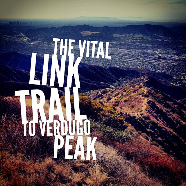
At 0.3 miles, we had a short breather as the trail mostly leveled out for a bit. At 0.5 miles, we reached the sign for the Vital Link Trail, and begain climbing nearly straight up the ridgeline.

The Vital Link Trail

The Vital Link Trail traces the ridgeline all the way to the Verdugo Motorway trail — which in turn traverses the backbone of the Verdugo Mountains. Vital Link is built with a series of short-but-steep switchbacks, shored to prevent erosion with barriers to discourage short-cutting the trail.

Looking back down

As we climbed, we stopped to catch our breath and enjoy the views, which soon grew to include Downtown Los Angeles, Palos Verdes and in the distance, Catalina Island.

At 1.5 miles, we reached the top of the Vital Link Trail. This is a good place to regroup before continuing. There is even a chair where you can rest.

Panorama at the Top of the Vital Link Trail

There are plenty of hikers and trail runners who use the Vital Link Trail as their own outdoor workout. But we wanted to bag the tallest summit in the Verdugos — Verdugo Peak.

From the Vital Link Trail, you can choose to turn left or right on the fire road. We started out to the right, but this leads to a dead end with a cluster of communication equipment. We retraced our steps and continued for a short downhill stretch to connect with the Verdugo Motorway, then turned right, heading east toward the summit.

You will notice a number of pine trees and a mix of fairly new growth trees. This is the Warden’s Garden — part of an experimental forest planted decades ago. Most of it burned in a wildfire, but some new growth has sprung back in it’s place.

The. Best. Trail. Sign. Ever.

At 2.18 miles, we ran across proof that rangers have a wicked sense of humor.

Smokers Will Be Fed to the Bears

We continued east on the Verdugo Motorway. At 2.77 miles, a spur road heads to the right up to a small communications building surrounded by five tall wood poles. This, sadly, is the summit of Verdugo Peak. We didn’t find a benchmark but it’s documented as 3,126 feet above sea level. And while the building on the summit takes away from the summit experience, it doesn’t take away from the views.

The Valley

And looking towards the San Gabriel Mountains…

The San Gabriel Mountains

This is your turnaround point on the trail. We headed back along the Verdugo Motorway for about 1.25 miles, then back down the Vital Link Trail to our car.

This trail provided a great workout, and excellent views of LA and the San Gabriel Mountains. I look forward to hiking this again when the local mountains are blanketed in snow. It’s a great vantage point for taking photos of the San Gabriels.

Overview Video of the Vital Link Trail and Verdugo Peak

[responsive_youtube YF88pehHvA0]

Vital Link to Verdugo Peak Trail Map

© OpenStreetMap contributors
Download file: Vital-Link-Trail-to-Verdugo-Peak.gpx

Photo Gallery

Click on any photo to view a larger version. You can also leave comments on any photo.

Can you find the deer?
Trailhead
Low Clearance
Looking Down on Burbank
Burbank Police Station
Climbing Switchbacks
Heading Up the Ridge
Downtown LA
Looking Back Down the Ridge
Wildwood Canyon Map
Vital Link Trail Sign
Picnic Area
More Switchbacks
Stay Left at this Junction
Looking back down
The Alternate Trail Reconnects Here
Panoramic Wow
More elevation gain
Burbank Airport
The Valley is Getting Smaller
Nearing the Top
A Chair for Resting
Top of the Vital Link Trail
Panorama at the Top of the Vital Link Trail
Equipment
Looking Over Warden's Grove
Warden's Grove
Plantation Lateral
Smokers Will Be Fed to the Bears
Looking at Downtown LA
The Valley
At the top of Verdugo Peak
Yoda on Verdugo Peak
The San Gabriel Mountains
Jeff & Joan
Heading Back Down
Almost back

Vital Link Trail Tips

  • Bring sun protection, plenty of water (I recommend 2 liters) and the 10 essentials
  • Avoid hiking this trail in extreme heat
  • We used trekking poles, and were glad to have them along

More Vital Link Trail Resources

  • The address for Wildwood Canyon Park is 1701 Wildwood Canyon Rd, Burbank, CA 91501
  • Verdugo Peak Hike – Dan’s Hiking Blog

Burbank Weather Forecast

The location could not be found.

Filed Under: Trail Guides Tagged With: 3-6 miles, Burbank, dog-friendly, LA County, moderate, peakbagging, Verdugo Mountains

Like what you found here at SoCal Hiker? This site is a labor of love. Share your support for the site and help us development of new trail guides and expanded coverage -- make your next outdoor equipment purchase through our advertisers.

You can also subscribe to our weekly newsletter and follow us on Facebook or Twitter.

Jeff H

About Jeff H

I'm an avid hiker and backpacker. My wife Joan and I are on the trails every weekend. I started SoCal Hiker to share my passion for outdoor adventure.

Comments

  1. Jacob says

    March 16, 2021 at 11:55 pm

    Be careful of the new swing on the summit near Verdugo Peak. It’s easy to hit your head on the tree branch on the backswing. I nearly knocked myself out.

    Reply

Leave a Reply Cancel reply

Your email address will not be published. Required fields are marked *

This site uses Akismet to reduce spam. Learn how your comment data is processed.

About SoCal Hiker

Jeff on Mount Rainier

I created SoCal Hiker while preparing to thru-hike the John Muir Trail. My goal? Create guides for the best hiking and backpacking trails with enough detail to make it an enjoyable experience for you. And while I started with trails in Southern California, I’ve expanded across the west. We hike each trail to create these guides, sharing practical advice on gear and outdoor skills. Read more…

Connect with SoCal Hiker

  • 22,757 Fans
  • 11,939 Followers
  • Followers
  • 1,719 Followers
  • 5,281 Subscribers
  • 341 Subscribers
SoCalHiker was selected one of USA TODAY's 10 Best Hiking and Outdoor Blogs
Get our day-by-day guide to thru-hiking the John Muir Trail
Get up-to-day wildfire status throughout California

Products

  • #MuirTaco stickers Muir Taco Stickers (2-pack) $3.00
  • San Gorgonio Benchmark San Gorgonio Benchmark $39.95
  • Mount San Jacinto T-Shirt $23.00 – $25.00
  • Gift Certificate Gift Certificate

Sponsors

Sponsor SoCalHiker and see your banner here

Featured Posts

Backpacking the Grand Canyon of Tuolumne Loop in Yosemite National Park

Yosemite National P ark, and in particular Yosemite Valley, is home to some of the … [Read More...]

Hiking Belknap Crater in the Mountain Washington Wilderness

Hiking this out-and-back route up Belknap Crater you'll traverse an other-worldly … [Read More...]

Hiking to the Simpson Reef Overlook on the Oregon Coast Trail

The Oregon Coast is rugged, beautiful and often uncrowded. This bluff-top … [Read More...]

Lastest Comments

  • Amy Courtney on Ridgeline Trail
  • Jay Eleanor on Hiking to the Simpson Reef Overlook on the Oregon Coast Trail
  • Charles Krim on Hiking to the Simpson Reef Overlook on the Oregon Coast Trail
  • 11 Best California Bikepacking Routes | Wild Lumens on Inside Crystal Cove State Park
  • Ted Thed on Burbank Peak, Cahuenga Peak, Mt. Lee and the Hollywood Sign
Get your SoCalHiker stickers now

Get your SoCalHiker stickers!

Latest Posts

  • Backpacking the Grand Canyon of Tuolumne Loop in Yosemite National Park March 24, 2023
  • Hiking Belknap Crater in the Mountain Washington Wilderness October 20, 2022
  • Hiking to the Simpson Reef Overlook on the Oregon Coast Trail August 25, 2022
  • Join Team SoCalHiker at the Climb for Heroes August 23, 2022
  • Hiking the Welch-Dickey Loop in the White Mountain National Forest August 18, 2022

Recent Forum Topics

  • Lost Coast Trail
  • How to deal with accidents while hiking in the winter?
  • Warm Tips for your hiking in winter
  • Some tips for hiking.
  • Keep your body warm in the winter hiking

The Six-Pack of Peaks Challenge Series

Six-Pack of Peaks Challenge SeriesThe Six-Pack of Peaks Challenge Series gives you an opportunity to explore your world while supporting a great cause. There are eleven challenges around the country. Hike or run them at your own schedule.

Flex your adventure muscles!

Learn more here.


Search

Tags

3-6 miles 6-8 miles 8-10 miles 11+ miles Arizona Backpacking coastal dog-friendly easy family-friendly High Sierra Trail hiking Hiking The John Muir Trail hipster inspiration JMT John Muir John Muir Trail Kings Canyon National Park LA County moderate Mount Rainier National Park Muir Monday National Park Orange County Oregon out of bounds Pacific Crest Trail peak peakbagging quote scenic Sequoia National Park Sierra Nevada Six-Pack of Peaks State Park strenuous Thru-hiking Utah vista Washington waterfall wilderness Wonderland Trail Yosemite

Copyright © 2023 SoCalHiker.net · Metro Theme on Genesis Framework with WPEngine Hosting · Contact SoCal Hiker · Sitemap · Privacy Policy


Loading Comments...