• COVID-19 Park and Trail Closures
  • Learn about the Six-Pack of Peaks Challenge
  • Shop
  •  

SoCal Hiker

  • Find a Hiking Trail
    • All Areas
    • Arizona
    • Colorado
    • Los Angeles
    • Orange County
    • Oregon
    • San Francisco Bay
    • Washington
  • Trail Guides
  • Six-Pack of Peaks
    • Colorado Six-Pack of Peaks
      • Bergen Peak
      • Rocky Mountain
      • Birthday Peak
      • Horseshoe Mountain
      • Grays Peak
    • New England Six-Pack of Peaks
    • NorCal Six-Pack of Peaks
      • Mount Umunhum
      • Mount Saint Helena
      • Mount Tamalpais
      • Mount Diablo
      • Mount Sizer
      • Rose Peak
    • Oregon Six-Pack of Peaks
      • Tumalo Mountain
      • Black Butte
      • Black Crater
      • Maiden Peak
      • Mount Bachelor
      • South Sister
    • SoCal Six-Pack of Peaks
      • Mt. Wilson
      • Cucamonga Peak
      • Mt. San Antonio (Mt Baldy)
      • San Bernardino Peak
      • San Jacinto Peak
      • San Gorgonio
  • Backpacking
    • High Sierra Trail
    • John Muir Trail
      • Overview of the John Muir Trail
      • Training
      • Day-by-Day Itinerary
      • Resupply Addresses
      • JMT Discussion Forum
    • Lost Coast Trail
    • North/South Lake Loop
    • Rae Lakes Loop
    • Red Peak Pass Loop
    • Theodore Solomons Trail
    • Trans-Catalina Trail
    • Wonderland Trail
  • Gear
  • Forums
    • Latest Topics
    • Ask a Question
    • Campfire
    • Trails
    • Trail Reports
    • Gear Wisdom
    • Classifieds
  • Login

Sitton Peak Trail

May 21, 2010 By Jeff H 18 Comments

On Sitton Peak

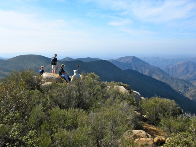
At 3,273 feet above sea level, Sitton Peak has commanding 360 degree views of the Cleveland National Forest. On clear days, you can see the ocean and  even Catalina Island. The elevation gain and distance makes this a good intermediate level hike.

img
Trail Details
Distance: 10 miles
Time: 4 hours
Difficulty: Moderate
Elevation gain: 2,150 ft
Dogs: OK
When to go: Fall through Spring
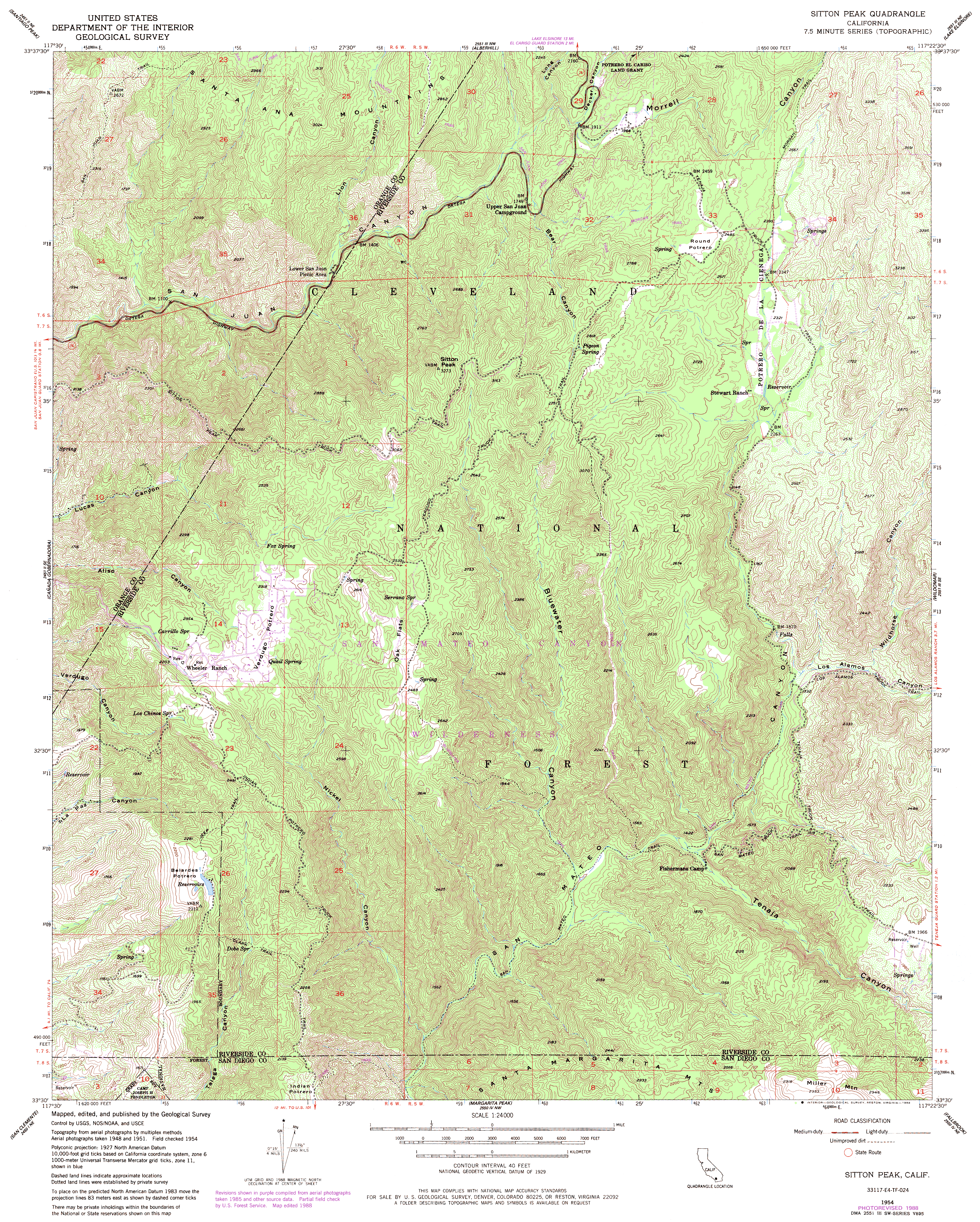
The first section of the trail is single track, but much of the trail follows double track fire roads, all well maintained and marked. Even so,  bring a map. There are a couple of junctions and it’s helpful to know which way to turn.

As you get closer to Sitton Peak, keep an eye out for the trail marker (it will be on your right). The “trail” to the top is not maintained and often overgrown. If you’re not paying attention, you could pass it by. The last quarter mile requires a little scrambling and bushwacking to reach the summit. No special equipment required, but you might want long pants to protect your legs from scratches.

The summit makes a great place to break for a snack or lunch and enjoy the views. When it’s clear, you can see the Pacific Ocean. On the return trip, take the ridge trail option. It adds a little extra mileage, but gives you some different scenery to enjoy and takes you back to the same junction with the Morgan Trail.

There is no water along the trail, so bring plenty for the round trip. This area gets pretty hot in the summer months. It’s still do-able, but you’ll enjoy the fall through spring season best. If possible, hike this on a clear day so you can really appreciate the views.

© OpenStreetMap contributors
Download file: sitton-peak.gpx

Trailhead

There is ample parking in a lot across Ortega Highway from the Candy Store (Google Map). You’ll need a National Forest Adventure Pass, which can also be purchased at the Candy Store. If you do more than six hikes in National Forest a year, it’s worth buying the annual pass.

Photo Gallery

Click any image for a larger version, and to browse through all of the photos.


Additional Resources

  • Sitton Peak USGS Topo Map
  • Sitton Peak trail topo with elevation profile

Filed Under: Trail Guides Tagged With: 8-10 miles, dogs, moderate, peak, peakbagging, vista, wilderness

Like what you found here at SoCal Hiker? This site is a labor of love. Share your support for the site and help us development of new trail guides and expanded coverage -- make your next outdoor equipment purchase through our advertisers.

You can also subscribe to our weekly newsletter and follow us on Facebook or Twitter.

Jeff H

About Jeff H

I'm an avid hiker and backpacker. My wife Joan and I are on the trails every weekend. I started SoCal Hiker to share my passion for outdoor adventure.

Comments

  1. Frank says

    November 5, 2010 at 6:15 pm

    Great website! I liked your Sitton Peak review. We hiked it last weekend and it was a real fun hike. I posted some pixs on our site.
    Cheers!
    Frank

    Reply
    • Jeff says

      January 6, 2011 at 11:18 am

      Thanks, Frank! I just checked out your site. Great pics. Sounds like you hiked it on a really clear day if you could see San Clemente Island!

      I’m thinking that with all the rain we’ve been having, this would be a good time to hike Sitton Peak again.

      Reply
  2. Pamela says

    February 25, 2011 at 12:58 pm

    Hello,
    I just came upon your site as I’m searching for trails in the Cleveland National Forest area. We live in Sycamore Creek just off the 15 south of Corona (on the other side of the 15 from Lee Lake – Indian Truck Trail exit). Is it possible to hike to Santiago Peak from this area? Have you done this hike? Any info would be helpful.
    Your site is helpful; particularly the maps and visuals of the area. The contour maps and elevations have helped me identify the peaks I see from my neighborhood. After relocating from the relative flat land of the Upper Midwest, it’s fun to explore the immediate surroundings.
    Happy hiking!

    Reply
    • Jeff Hester says

      March 3, 2011 at 6:09 pm

      Hi Pamela! Thanks for stopping by the site!

      I haven’t hiked up Santiago from the east, but it technically is possible. Both Bedford Motorway and Indian Truck Trail roads become fire roads that climb all the way to the Main Divide road, which then leads to Santiago and other peaks in the range. As for trails, I’m pretty sure they are there, but can’t vouch for how well maintained they are. I would suggest calling the ranger at the Forest Service and asking if they have any info.

      If you do find out about a trail from “your” side of the mountain, let me know! I’ll add it to my hiking wish list.

      Reply
  3. Vikram Reddy says

    June 27, 2011 at 11:08 am

    A newbie to hiking. Want to take my niece, nephew and son on a hike up to to Sitton Peak in mid July. Any advice would be appreciated? Will it be too hot? How long will it take and what is the earliest possible start.

    Thanks

    Reply
    • Jeff Hester says

      June 29, 2011 at 11:39 pm

      Vikram, it will likely be hot and dry in July. If you go, take plenty of water and start early. There is no limit to how early, but I would plan for 6am or so.

      Reply
    • John Malloy says

      July 11, 2011 at 10:24 pm

      Did this hike once in January and again 2 weeks ago. Cool weather is the way to go as this trail is exposed to the sun about 1/2 the time and the last scramble to the top can be a bit much in hot weather. Bring at least 3 liters of water (none available on the trail). Don’t miss the well pump in the back parking lot, very refreshing after a long hike.

      Reply
  4. Mike says

    April 15, 2012 at 6:13 am

    Very informative site. Keep up the good work. I’m pretty new to hiking but I’ve recently caught the bug. Where do I find maps the same as the one you linked above “Sitton Peak trail topo with elevation profile”? I’d like to have a similar map for all of my planned routes.

    Reply
    • Dennis says

      January 25, 2020 at 5:20 pm

      Try hiking apps. I like “All Trails” but there are others out there.

      Reply
  5. Tracy says

    November 18, 2012 at 10:05 pm

    My Darling and I attempted this in July (he’d done it before, that was my first attempt). I made it 2 miles before I was dying of hunger and heat. We started after first service at church in Eastvale, so about 10a and I hadn’t carbed up at all. Talk about ridiculous!

    We did this yesterday (November). It was chilly, but the coats came off at about mile 1. With pancake deliciousness to carb up, and adequate water, we did this in 4 hours (as you said), and spent almost an hour at the top, enjoying a snack and the scenery. It was vastly beautiful, and much more pleasant than in July with the heat.

    Beside the heat, the major difference was the color – there was a lot more of it during the summer. Still quite lovely! Even with how overcast it was yesterday (it sprinkled on us here and there), we were still able to see the ocean.

    Great review!

    Reply
    • Jeff Hester says

      November 19, 2012 at 8:33 am

      Thanks for the feedback, Tracy. Glad you made it up there an enjoyed the view. It does get hot in the summer, which is why I personally consider this more of a fall-through-spring kind of hike. For a great contrast with the fall, try it again in the spring when things are really green!

      Reply
  6. Sherri says

    October 10, 2013 at 6:40 am

    Hi Jeff, I have a hike to Sitton Peak planned for November, but I am a bit concerned about the final scramble to the top. My concern is coming back down that portion as I have never scrambled and I don’t know what to expect. How do you navigate the way down? I guess I am looking for a bit of technical advice since I don’t know anyone to ask. I am confident the rest of the hike wont pose a problem. I have been hiking regularly for 7 months and have been on a few 9 mile hikes, including all the more strenuous hills I.e. Dreaded, Mathis, BFI, etc. and can keep a good pace. Ay advice would be greatly appreciated.

    Reply
  7. Jeff HJeff Hester says

    October 10, 2013 at 4:45 pm

    @Sherri, the scramble up the last bit to Sitton Peak is not that bad. There is nothing technical about it. It’s just steep and you have to pick your way through the scrub. Take your time and you’ll be fine. A trekking pole might come in handy here, although with the scrub it might also be a pain. The main point is that it’s not just “hiking” to the top. You have to slow down and just use a little extra caution. No bouldering or climbing required.

    Reply
    • Sherri says

      October 11, 2013 at 8:02 pm

      Thank you, Jeff! I will just go for it. 🙂

      Reply
  8. Hayley says

    September 8, 2016 at 10:25 am

    Where do we park if we don’t have an adventure pass?

    Reply
  9. Alicia says

    October 4, 2016 at 12:40 pm

    I took two trips to Cleveland National Park hoping to find the entrance to Sitton Peak. I failed to realize that it was across the street from the parking lot. How far from the parking lot is the entrance? And is it dangerous crossing the highway to get there?

    Reply
  10. Sean says

    October 10, 2016 at 7:11 am

    If you walk out to the road from the parking lot, you can see the entrance to the right of the little candy store, you get to it by walking on the shoulder of the road a very short distance. It’s marked as Bear Canyon Trail or something like that, it won’t say Sitton, which confused me a little.

    Reply

Leave a Reply Cancel reply

Your email address will not be published. Required fields are marked *

This site uses Akismet to reduce spam. Learn how your comment data is processed.

About SoCal Hiker

Jeff on Mount Rainier

I created SoCal Hiker while preparing to thru-hike the John Muir Trail. My goal? Create guides for the best hiking and backpacking trails with enough detail to make it an enjoyable experience for you. And while I started with trails in Southern California, I’ve expanded across the west. We hike each trail to create these guides, sharing practical advice on gear and outdoor skills. Read more…

Connect with SoCal Hiker

  • 22,751 Fans
  • 11,946 Followers
  • 21,640 Followers
  • 1,717 Followers
  • 5,281 Subscribers
  • 342 Subscribers
SoCalHiker was selected one of USA TODAY's 10 Best Hiking and Outdoor Blogs
Get our day-by-day guide to thru-hiking the John Muir Trail
Get up-to-day wildfire status throughout California

Products

  • 2017 Six-Pack of Peaks Sticker 2017 Six-Pack of Peaks Sticker $3.00
  • Mt San Gorgonio Mug San Gorgonio Mug $15.95
  • Señor Muir Taco Hut T-Shirt $19.00 – $27.50
  • Mount Wilson Benchmark Mount Wilson Benchmark $39.95

Sponsors

Sponsor SoCalHiker and see your banner here

Featured Posts

Hiking Belknap Crater in the Mountain Washington Wilderness

Hiking this out-and-back route up Belknap Crater you'll traverse an other-worldly … [Read More...]

Hiking to the Simpson Reef Overlook on the Oregon Coast Trail

The Oregon Coast is rugged, beautiful and often uncrowded. This bluff-top … [Read More...]

Join Team SoCalHiker at the Climb for Heroes

Team SoCalHiker is climbing Mount Baldy again as part of the annual Climb for Heroes … [Read More...]

Lastest Comments

  • Amy Courtney on Ridgeline Trail
  • Jay Eleanor on Hiking to the Simpson Reef Overlook on the Oregon Coast Trail
  • Charles Krim on Hiking to the Simpson Reef Overlook on the Oregon Coast Trail
  • 11 Best California Bikepacking Routes | Wild Lumens on Inside Crystal Cove State Park
  • Ted Thed on Burbank Peak, Cahuenga Peak, Mt. Lee and the Hollywood Sign
Get your SoCalHiker stickers now

Get your SoCalHiker stickers!

Latest Posts

  • Hiking Belknap Crater in the Mountain Washington Wilderness October 20, 2022
  • Hiking to the Simpson Reef Overlook on the Oregon Coast Trail August 25, 2022
  • Join Team SoCalHiker at the Climb for Heroes August 23, 2022
  • Hiking the Welch-Dickey Loop in the White Mountain National Forest August 18, 2022
  • Hiking Turtlehead Peak from Red Rock Canyon National Conservation Area July 15, 2022

Recent Forum Topics

  • How to deal with accidents while hiking in the winter?
  • Warm Tips for your hiking in winter
  • Some tips for hiking.
  • Keep your body warm in the winter hiking
  • The benefits of hiking, more than you can imagine!

The Six-Pack of Peaks Challenge Series

Six-Pack of Peaks Challenge SeriesThe Six-Pack of Peaks Challenge Series gives you an opportunity to explore your world while supporting a great cause. There are eleven challenges around the country. Hike or run them at your own schedule.

Flex your adventure muscles!

Learn more here.


Search

Tags

3-6 miles 6-8 miles 8-10 miles 11+ miles Arizona Backpacking coastal dog-friendly easy family-friendly High Sierra Trail hiking Hiking The John Muir Trail hipster inspiration JMT John Muir John Muir Trail Kings Canyon National Park LA County moderate Mount Rainier National Park Muir Monday National Park Orange County Oregon out of bounds Pacific Crest Trail peak peakbagging quote scenic Sequoia National Park Sierra Nevada Six-Pack of Peaks State Park strenuous Thru-hiking Utah vista Washington waterfall wilderness Wonderland Trail Yosemite

Copyright © 2023 SoCalHiker.net · Metro Theme on Genesis Framework with WPEngine Hosting · Contact SoCal Hiker · Sitemap · Privacy Policy


Loading Comments...