• Learn about the Six-Pack of Peaks Challenge
  •  

SoCal Hiker

  • Find a Hiking Trail
    • All Areas
    • Arizona
    • Colorado
    • Los Angeles
    • Orange County
    • Oregon
    • San Francisco Bay
    • Washington
  • Trail Guides
  • Six-Pack of Peaks
    • Colorado Six-Pack of Peaks
      • Bergen Peak
      • Rocky Mountain
      • Birthday Peak
      • Horseshoe Mountain
      • Grays Peak
    • New England Six-Pack of Peaks
    • NorCal Six-Pack of Peaks
      • Mount Umunhum
      • Mount Saint Helena
      • Mount Tamalpais
      • Mount Diablo
      • Mount Sizer
      • Rose Peak
    • Oregon Six-Pack of Peaks
      • Tumalo Mountain
      • Black Butte
      • Black Crater
      • Maiden Peak
      • Mount Bachelor
      • South Sister
    • SoCal Six-Pack of Peaks
      • Mt. Wilson
      • Cucamonga Peak
      • Mt. San Antonio (Mt Baldy)
      • San Bernardino Peak
      • San Jacinto Peak
      • San Gorgonio
  • Backpacking
    • High Sierra Trail
    • John Muir Trail
      • Overview of the John Muir Trail
      • Training
      • Day-by-Day Itinerary
      • Resupply Addresses
      • JMT Discussion Forum
    • Lost Coast Trail
    • North/South Lake Loop
    • Rae Lakes Loop
    • Red Peak Pass Loop
    • Theodore Solomons Trail
    • Trans-Catalina Trail
    • Wonderland Trail
  • Gear

Plank Walk Trail to Mt Tamalpais

May 2, 2014 By Jeff H Leave a Comment

Hike The Plank Walk Trail to Mt Tam

This short, family-friendly trail was an impromptu birthday peak bagged by my mom, my wife and I as part of the second part of our spring break road trip. It’s barely over half a mile round trip, but gains at a steady pace, climbing over 250 feet in a quarter mile. And while it might not win you respect for the mileage, the Plank Walk Trail rewards you with stunning views of San Francisco and the bay out to the Pacific Ocean from atop Mt. Tamalpais.

img
Trail Details
Distance: 0.6 miles
Time: 30 min.
Difficulty: Easy
Elevation gain: 261 ft
Dogs: No
When to go: Year-round
Driving directions
There are many ways to hike up Mt Tam, but this is the shortest and easiest. Mt. Tam actually has two peaks; the lower west peak is fenced off and covered with antennae, while the taller east peak is capped with a fire lookout. You can drive to the saddle between the two, where you’ll find a parking lot, a visitor center and a bit of history — one of the old gravity cars that used to thrill riders a century ago.

While the trail is short and I’d describe it as easy, it actually is fairly steep and sections are rugged. Young kids can manage with supervision, but don’t let them wander off-trail!

The Plank Walk Trail

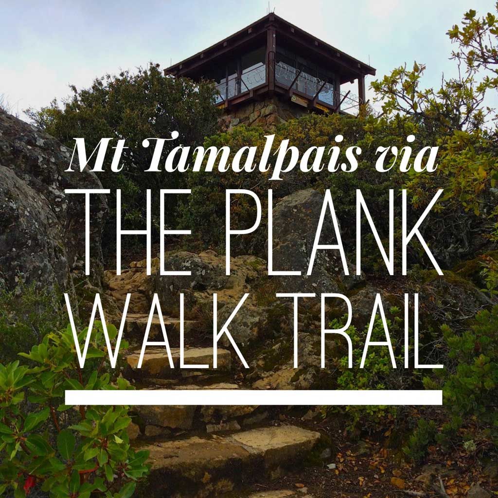
From the end of the parking lot you can’t miss the start of the Plank Walk Trail. It’s the trail literally made of planks (at least for the first section).

The Plank Walk Trail begins as... planks!

The first 0.1 miles of the trail is paved with wood planks — old railroad ties, actually — and bordered on the downhill side with a hand rail, making it look deceptively easy. You quickly gain elevation and the views expand.

My mom and my wife hiking up the final switchbacks to Mt. Tam

Soon you look up and see the fire lookout tower the sits atop the East Peak of Mt. Tamalpais. The views are breathtaking. On a clear day, visitors can see the Farallon Islands 25 miles out to sea, the Marin County hills, San Francisco and the bay, hills and cities of the East Bay, and Mount Diablo. On rare occasions, the Sierra Nevada’s snow-covered mountains can be seen 150 miles away. 

Mt Tam panorama

It was windy and chilly on this particular spring day, and we took photos, soaked in the views, and headed back down the trail, where the scrub protected us from the chilling winds.

Back at the visitor center, we checked out the old gravity cars and imagined what it was like when the old trail carried people to the lodge up here.

Mt. Tamalpais is worth a visit, even for a short little hike like this. The views are unique, and it’s easy to string together a series of micro-adventures into a full-day itinerary. For all the times I’ve visited the bay area, I had never before been to Mt. Tam. Now I can say to you — take a hike… up Mt Tam! It’s worth it.

Plank Walk Trail Map to Mt. Tamalpais East Peak

© OpenStreetMap contributors
Download file: Plank Walk Trail to Mt Tamalpais.gpx

Photo Gallery

Click on any photo to view a larger version. You can also leave comments on any photo.

The Plank Walk Trail begins as... planks!
My mom and my wife hiking up the final switchbacks to Mt. Tam
IMG_3379
Prayer flags on Mt Tam
The USGS Benchmark atop Mt Tam
The fire lookout on Mt Tamalpais
IMG_3384
View of the San Francisco Bay from the top of Mt Tamalpais
Mt Tam panorama
IMG_3396

Mt. Tamalpais Resources

  • Mt. Tamalpais State Park is open 7am to sundown daily
  • Visitor Center
  • Friends of Mt. Tam – great resource with a calendar of scheduled events including guided hikes in the park
  • History of the Gravity Cars

Mt. Tamalpais Weather Forecast

[forecast width=”100%” location=”94941″]

And now, your moment of zen…

Filed Under: Trail Guides Tagged With: easy, family-friendly, Marin County, Mt Tamalpais, out of bounds, peak, peakbagging

Like what you found here at SoCal Hiker? This site is a labor of love. Share your support for the site and help us development of new trail guides and expanded coverage -- make your next outdoor equipment purchase through our advertisers.

You can also subscribe to our weekly newsletter and follow us on Facebook or Twitter.

About Jeff H

I'm an avid hiker and backpacker. My wife Joan and I are on the trails every weekend. I started SoCal Hiker to share my passion for outdoor adventure.

Leave a Reply Cancel reply

Your email address will not be published. Required fields are marked *

This site uses Akismet to reduce spam. Learn how your comment data is processed.

About SoCal Hiker

Jeff on Mount Rainier

I created SoCal Hiker while preparing to thru-hike the John Muir Trail. My goal? Create guides for the best hiking and backpacking trails with enough detail to make it an enjoyable experience for you. And while I started with trails in Southern California, I’ve expanded across the west. We hike each trail to create these guides, sharing practical advice on gear and outdoor skills. Read more…

Connect with SoCal Hiker

  • 22,734 Fans
  • 11,901 Followers
  • 21,640 Followers
  • 1,716 Followers
  • 5,281 Subscribers
  • 340 Subscribers
SoCalHiker was selected one of USA TODAY's 10 Best Hiking and Outdoor Blogs
Get our day-by-day guide to thru-hiking the John Muir Trail
Get up-to-day wildfire status throughout California

Products

  • 2017 Women's Six-Pack of Peaks Racerback Tank $27.00
  • Señor Muir Taco Hut T-Shirt $19.00 – $27.50
  • Come to the woods, for here is rest. - John Muir Come to the Woods Poster $13.00 – $16.00
  • San Bernardino benchmark San Bernardino Peak Benchmark $39.95

Sponsors

Sponsor SoCalHiker and see your banner here

Featured Posts

Mobil odeme secenekleri sunan casinolar 2023

Bu sebepten dolayı da kimi zaman eriÅŸim engelleri alma durumları olur. Fakat buna … [Read More...]

Sustanon 250 steroid: tutto cio che devi sapere

Sustanon 250: Una panoramica sullo steroide Cos'e Sustanon 250? … [Read More...]

Certain medications are better than others for managing spine pain

Certain medications are better than others for managing spine pain In the event of a … [Read More...]

Lastest Comments

  • Farzan on Hiking Mt San Jacinto via Humber Park in Idyllwild
  • Jeff H on Hiking Mt San Jacinto via Humber Park in Idyllwild
  • Farzan on Hiking Mt San Jacinto via Humber Park in Idyllwild
  • Jeff H on Hiking Black Crater
  • Tammy on Hiking Black Crater
Get your SoCalHiker stickers now

Get your SoCalHiker stickers!

Latest Posts

  • Mobil odeme secenekleri sunan casinolar 2023 September 20, 2023
  • Sustanon 250 steroid: tutto cio che devi sapere September 19, 2023
  • Certain medications are better than others for managing spine pain August 23, 2023
  • La pharmacie en ligne en Belgique est devenue une solution de plus en plus populaire pour les personnes cherchant à acheter des médicaments August 7, 2023
  • Las 5 mejores farmacias en línea1. Farmacia en línea Farmalisto: Esta reconocida farmacia cuenta con una amplia August 6, 2023

The Six-Pack of Peaks Challenge Series

The Six-Pack of Peaks Challenge Series gives you an opportunity to explore your world while supporting a great cause. There are eleven challenges around the country. Hike or run them at your own schedule.

Flex your adventure muscles!

Learn more here.


Search

Tags

3-6 miles 6-8 miles 8-10 miles 11+ miles Arizona Backpacking coastal dog-friendly easy family-friendly High Sierra Trail hiking Hiking The John Muir Trail inspiration JMT John Muir John Muir Trail Kings Canyon National Park LA County moderate Mount Rainier National Park Muir Monday National Forest National Park Orange County Oregon out of bounds Pacific Crest Trail peak peakbagging quote scenic Sequoia National Park Sierra Nevada Six-Pack of Peaks State Park strenuous Thru-hiking Utah vista Washington waterfall wilderness Wonderland Trail Yosemite

Copyright © 2023 SoCalHiker.net · Metro Theme on Genesis Framework with WPEngine Hosting · Contact SoCal Hiker · Sitemap · Privacy Policy


Loading Comments...