• COVID-19 Park and Trail Closures
  • Learn about the Six-Pack of Peaks Challenge
  • Shop
  •  

SoCal Hiker

  • Find a Hiking Trail
    • All Areas
    • Arizona
    • Colorado
    • Los Angeles
    • Orange County
    • Oregon
    • San Francisco Bay
    • Washington
  • Trail Guides
  • Six-Pack of Peaks
    • Colorado Six-Pack of Peaks
      • Bergen Peak
      • Rocky Mountain
      • Birthday Peak
      • Horseshoe Mountain
      • Grays Peak
    • New England Six-Pack of Peaks
    • NorCal Six-Pack of Peaks
      • Mount Umunhum
      • Mount Saint Helena
      • Mount Tamalpais
      • Mount Diablo
      • Mount Sizer
      • Rose Peak
    • Oregon Six-Pack of Peaks
      • Tumalo Mountain
      • Black Butte
      • Black Crater
      • Maiden Peak
      • Mount Bachelor
      • South Sister
    • SoCal Six-Pack of Peaks
      • Mt. Wilson
      • Cucamonga Peak
      • Mt. San Antonio (Mt Baldy)
      • San Bernardino Peak
      • San Jacinto Peak
      • San Gorgonio
  • Backpacking
    • High Sierra Trail
    • John Muir Trail
      • Overview of the John Muir Trail
      • Training
      • Day-by-Day Itinerary
      • Resupply Addresses
      • JMT Discussion Forum
    • Lost Coast Trail
    • North/South Lake Loop
    • Rae Lakes Loop
    • Red Peak Pass Loop
    • Theodore Solomons Trail
    • Trans-Catalina Trail
    • Wonderland Trail
  • Gear
  • Forums
    • Latest Topics
    • Ask a Question
    • Campfire
    • Trails
    • Trail Reports
    • Gear Wisdom
    • Classifieds
  • Login

Hiking Mt Baldy: Climb for Heroes 2015 Recap

April 20, 2015 By Jeff H 3 Comments

Team SoCalHiker

On April 12th, I had the privilege of hiking up 10,064′ Mt. Baldy, raising money for The Heroes Project. The annual event is called the Climb for Heroes, and the money helps wounded veterans — soldiers who have lost one or both legs in service — redefine who they are as they summit the highest peaks.

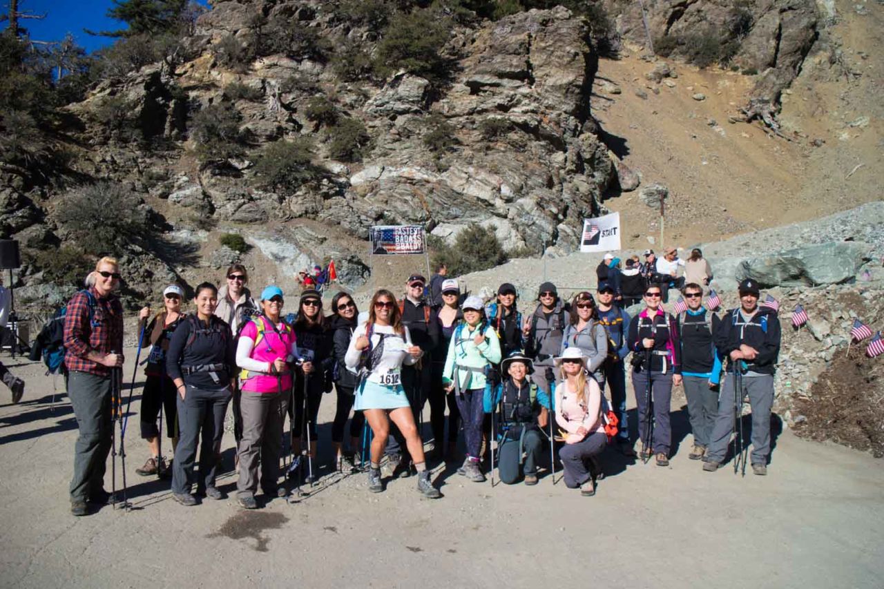
There were nearly 1,000 hikers participating, many of them hiking all the way to the summit. This was my first year participating, and in fact, I organized #TeamSoCalHiker. We had 49 SoCal hikers sign up, and together we raised $7,550 for The Heroes Project.

Our team was unique in that with only a couple of exceptions, many of us had never hiked together before. There were some couples, families and groups of friends on the team, any many of the team I’ve “met” through the SoCalHiker Facebook page, Twitter or Instagram. But this was our first hike together.

It was also unique in that this was my first time at the event. I learned a few things in the process, but I’ll get to that later. First the good stuff.

img
Trail Details
Distance: 12 miles
Time: 4-6 hours
Difficulty: Strenuous
Elevation gain: 3,535 ft
Top elevation: 10,064 ft
Dogs: Yes
When to go: Spring-Fall
49 hikers
$7550 raised
The sponsors of Climb for Heroes did a great job overall. The hike was divided into a series of “camps” modeled after the camps USMC Staff Sergeant Thomas Charles Linville will visit on his climb up Mt. Everest. The Mt Baldy Ski Resort parking lot was Base Camp. Sponsors provided breakfast, snacks, coffee and coconut water. Parking was free (no Adventure Pass required).

Just finding all the team proved to be our first challenge. If you count the folks in the photo above, you’ll note that many team members are missing. Some team members got an early start and some we saw on the way up (or down… or not at all). The more experienced teams had t-shirts and a better plan for meeting. Next year…

The first half mile was steep! We ascended 500 feet in that first half mile, climbing to the fire road from Manker Flat. Once we reached the fire road, it felt like we found some new legs.

The First Section was Steep!_

Camp 1 was at the first mile marker and we’d already climbed 770 feet vertically. We queued up to shake hands with one of the wounded vets, who also handed out custom poker chips. We would earn a new chip at each camp all the way to the summit.

Photo Op with a Veteran at Camp 2

Camp 2 was at 2.5 miles — just beyond The Notch at the junction with the 3-Ts trail — and we climbed another 500 feet to 7,800′. From here we took the service road that winds around the Mt Baldy ski runs, snaking our way up to…

Camp 3 — This camp was a turnaround point for some hikers. But those who made it this far could opt for a cold PBR (I declined… knowing what was still ahead). My reward would have to wait a while longer. Camp 3 was at the 3.6 mile mark and an elevation of 8,537 feet. This also marked the beginning of the Devil’s Backbone Trail.

The Devil’s Backbone Trail is one of the most scenic sections of the trail. It’s also the most treacherous. The wind whips you as it howls over the ridge line from east. The trail itself balances right along that ridge — when it’s not traversing a steep slope of ever-changing scree. Trekking poles are a great plus here (a must-have in my book) but the event organizers went a step further and put a rope up to provide a handhold across the gnarliest section.

Peter Dancing on the Devil's Backbone

Once you pass the backbone, you make a bee-line to Mt Baldy, climbing diagonally along the western side of Mt Harwood. Poor Mt Harwood. Everyone hikes on it, but they’re mostly just passing by en route to Baldy. Very few visit the summit. Another time.

Camp 4 sat in the saddle between Baldy and Harwood. At this point, you’ve hiked 5.5 miles and are only half a mile and 750 vertical feet away from the summit. The altitude becomes a factor. And if you haven’t been drinking enough water, you’ll really feel it here.

The final push to the summit is steep, and a slow, steady pace is the best approach. The “trail” is really just a spiderweb of goat trails. You have to pick your way along, but mostly you go up… up… UP!

A Long Line of Hikers

Finally we reached Summit Camp, and were greeted by Gyalbu Sherpa and Linville himself.

Charlie Linville at the Summit

The summit of Mt Baldy is usually crowded on weekends, but I’d never seen it like this. There were hundreds of hikers up there, and a steady stream of folks coming and going. I had a chance to thank Linville for his service and wish him well on his quest to summit Everest, then we headed back down.

Our route back retraced our steps, but included a stop for lunch at The Notch — which graciously provided BOGO lunches for Climb for Heroes participants. We had the option of riding the ski lift back down, but decided to hike that last two miles to make it an honest 12 mile trek.

Usually I would make a loop out of this, but in this case, it was worth going back to Base Camp and exchanging our tokens for shwag.

Special Thanks

I’m honored that so many people joined #TeamSoCalHiker, and many of you raised more than the minimum $100 target. I’d like to extend a special thanks to our top three fundraisers:

  • Mike Simms raised a whopping $1500! Way to go, Mike!
  • Susan Tracy raised $660!
  • Roxane Bukacek raised $560… and she made awesome red-white-and-blue paracord survival bracelets for the team and the soldiers on the trail.

Thanks to everyone on the team. I really appreciate meeting so many of you and hope to catch up with those I missed on another hike in the future. You all rock!

Follow Charlie

Charlie Linville is already already in Nepal. You can follow along on his Everest climb via updates on The Heroes Project’s Facebook page.

Climb for Heroes 2015 Trail Map

© OpenStreetMap contributors
Download file: Mt Baldy - Climb for Heroes 2015.gpx

Climb for Heroes Photo Gallery

Click on any photo to view a larger version. You can also leave comments on any photo.


Mt Baldy Tips & Trivia

  • Mt Baldy’s real name is Mt. San Antonio
  • The Mt Baldy Ski Resort hosts full-moon hikes when the snow melts (i.e. now). They have special packages that include a BBQ buffet, live music at The Notch and the option of adding a lift — up, down or both. Not a bad way to explore the area and catch the sunset.
  • For more details on the area an my recommended loop hike, read Hiking Mt San Antonio (Mt Baldy) Loop.
  • Find more photos from the event on Instagram: #TeamSoCalHiker

Final Notes

To all the #TeamSoCalHikers out there who summited Mt Baldy, you’ve bagged one of the Six-Pack of Peaks. Which one will you summit next?

Filed Under: Hiking News Tagged With: 11+ miles, dog-friendly, LA County, peakbagging, scenic, strenuous

Like what you found here at SoCal Hiker? This site is a labor of love. Share your support for the site and help us development of new trail guides and expanded coverage -- make your next outdoor equipment purchase through our advertisers.

You can also subscribe to our weekly newsletter and follow us on Facebook or Twitter.

Jeff H

About Jeff H

I'm an avid hiker and backpacker. My wife Joan and I are on the trails every weekend. I started SoCal Hiker to share my passion for outdoor adventure.

Comments

  1. Joel says

    January 23, 2016 at 8:45 pm

    Did you have to go back on the Devil’s Backbone on your way back?

    Reply
  2. Natalie says

    March 9, 2016 at 8:28 pm

    Jeff are various levels of hikers welcome to your group? I just don’t want to slow people down. I’m fairly fit, going after Mt Wilson for the second time week after next.

    Reply
    • Jeff HJeff Hester says

      March 10, 2016 at 8:14 am

      This event is a huge event, and the group will naturally break into smaller groups at any number of speeds. Last year there were nearly 1000 people there — so staying as one big group is not really practical. What I suggest is posting in the forums and finding others who like your pace.

      Reply

Leave a Reply Cancel reply

Your email address will not be published. Required fields are marked *

This site uses Akismet to reduce spam. Learn how your comment data is processed.

About SoCal Hiker

Jeff on Mount Rainier

I created SoCal Hiker while preparing to thru-hike the John Muir Trail. My goal? Create guides for the best hiking and backpacking trails with enough detail to make it an enjoyable experience for you. And while I started with trails in Southern California, I’ve expanded across the west. We hike each trail to create these guides, sharing practical advice on gear and outdoor skills. Read more…

Connect with SoCal Hiker

  • 22,735 Fans
  • 11,941 Followers
  • 21,640 Followers
  • 1,717 Followers
  • 5,275 Subscribers
  • 338 Subscribers
SoCalHiker was selected one of USA TODAY's 10 Best Hiking and Outdoor Blogs
Get our day-by-day guide to thru-hiking the John Muir Trail
Get up-to-day wildfire status throughout California

Products

  • Mt Whitney Replica Benchmark Mt Whitney Benchmark $39.95
  • Cucamonga Peak mug Cucamonga Peak Mug $15.95
  • Come to the woods, for here is rest. - John Muir Come to the Woods Poster $13.00 – $16.00
  • Cucamonga Peak T-Shirt $23.00 – $27.50

Sponsors

Sponsor SoCalHiker and see your banner here

Featured Posts

Hiking Belknap Crater in the Mountain Washington Wilderness

Hiking this out-and-back route up Belknap Crater you'll traverse an other-worldly … [Read More...]

Hiking to the Simpson Reef Overlook on the Oregon Coast Trail

The Oregon Coast is rugged, beautiful and often uncrowded. This bluff-top … [Read More...]

Join Team SoCalHiker at the Climb for Heroes

Team SoCalHiker is climbing Mount Baldy again as part of the annual Climb for Heroes … [Read More...]

Lastest Comments

  • Greg on Rae Lakes Loop via Kearsarge Pass
  • Tim Wilson on Rae Lakes Loop via Kearsarge Pass
  • Pam Selthun on Backpacking the Wonderland Trail
  • Calico Maps on Hiking Monserate Mountain
  • Deborah Aguanno on Mt. Wilson via Chantry Flats
Get your SoCalHiker stickers now

Get your SoCalHiker stickers!

Latest Posts

  • Hiking Belknap Crater in the Mountain Washington Wilderness October 20, 2022
  • Hiking to the Simpson Reef Overlook on the Oregon Coast Trail August 25, 2022
  • Join Team SoCalHiker at the Climb for Heroes August 23, 2022
  • Hiking the Welch-Dickey Loop in the White Mountain National Forest August 18, 2022
  • Hiking Turtlehead Peak from Red Rock Canyon National Conservation Area July 15, 2022

Recent Forum Topics

  • How to deal with accidents while hiking in the winter?
  • Warm Tips for your hiking in winter
  • Some tips for hiking.
  • Keep your body warm in the winter hiking
  • The benefits of hiking, more than you can imagine!

The Six-Pack of Peaks Challenge Series

Six-Pack of Peaks Challenge SeriesThe Six-Pack of Peaks Challenge Series gives you an opportunity to explore your world while supporting a great cause. There are eleven challenges around the country. Hike or run them at your own schedule.

Flex your adventure muscles!

Learn more here.


Search

Tags

3-6 miles 6-8 miles 8-10 miles 11+ miles Arizona Backpacking coastal dog-friendly easy family-friendly High Sierra Trail hiking Hiking The John Muir Trail hipster inspiration JMT John Muir John Muir Trail Kings Canyon National Park LA County moderate Mount Rainier National Park Muir Monday National Park Orange County Oregon out of bounds Pacific Crest Trail peak peakbagging quote scenic Sequoia National Park Sierra Nevada Six-Pack of Peaks State Park strenuous Thru-hiking Utah vista Washington waterfall wilderness Wonderland Trail Yosemite

Copyright © 2023 SoCalHiker.net · Metro Theme on Genesis Framework with WPEngine Hosting · Contact SoCal Hiker · Sitemap · Privacy Policy


Loading Comments...