• COVID-19 Park and Trail Closures
  • Learn about the Six-Pack of Peaks Challenge
  • Shop
  •  

SoCal Hiker

  • Find a Hiking Trail
    • All Areas
    • Arizona
    • Colorado
    • Los Angeles
    • Orange County
    • Oregon
    • San Francisco Bay
    • Washington
  • Trail Guides
  • Six-Pack of Peaks
    • Colorado Six-Pack of Peaks
      • Bergen Peak
      • Rocky Mountain
      • Birthday Peak
      • Horseshoe Mountain
      • Grays Peak
    • New England Six-Pack of Peaks
    • NorCal Six-Pack of Peaks
      • Mount Umunhum
      • Mount Saint Helena
      • Mount Tamalpais
      • Mount Diablo
      • Mount Sizer
      • Rose Peak
    • Oregon Six-Pack of Peaks
      • Tumalo Mountain
      • Black Butte
      • Black Crater
      • Maiden Peak
      • Mount Bachelor
      • South Sister
    • SoCal Six-Pack of Peaks
      • Mt. Wilson
      • Cucamonga Peak
      • Mt. San Antonio (Mt Baldy)
      • San Bernardino Peak
      • San Jacinto Peak
      • San Gorgonio
  • Backpacking
    • High Sierra Trail
    • John Muir Trail
      • Overview of the John Muir Trail
      • Training
      • Day-by-Day Itinerary
      • Resupply Addresses
      • JMT Discussion Forum
    • Lost Coast Trail
    • North/South Lake Loop
    • Rae Lakes Loop
    • Red Peak Pass Loop
    • Theodore Solomons Trail
    • Trans-Catalina Trail
    • Wonderland Trail
  • Gear
  • Forums
    • Latest Topics
    • Ask a Question
    • Campfire
    • Trails
    • Trail Reports
    • Gear Wisdom
    • Classifieds
  • Login

Hiking Gray Butte from Smith Rock State Park

February 11, 2020 By Jeffrey Hester Leave a Comment

Mount Hood in the distance

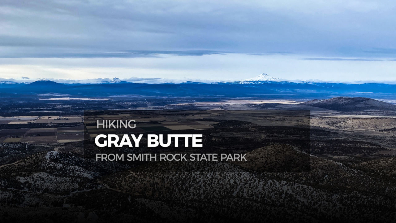
Gray Butte is not particularly rugged nor jagged. The soft-shouldered butte is home to a cluster of antennas and a utility road the climbs there. But this 13.3 mile out-and-back route begins and ends in beautiful Smith Rock State Park, taking you down across the Crooked River before climbing out of the park, across a private land easement, and into the Crooked River National Grassland where Gray Butte stands tall over Central Oregon.

img
Trail Details
Summit Elevation: 5,108′
Distance: 13.3 miles
Time: 5-7 hours
Difficulty: Strenuous
Elevation gain: 2,830 ft
Dogs: Yes
When to go: Fall through Spring
What the summit itself lacks in excitement, it makes up for with the stunning 360-degree views. My buddy Ben and I tackled this during the last days of December, and although it was overcast, we had amazing panoramic views of the Cascade Mountains, from Mount Bachelor to Mount Hood.

This trail is considered strenuous mainly for the net vertical gain and the distance, but the climb itself is moderate, with no overly steep or gnarly sections.

Getting to the Trailhead

We began at the Smith Rock State Park visitor center in Terrebonne, Oregon (get driving directions here). The parking at this popular park fills up early, especially on nice weekends. In late December, we had plenty of parking, although it was full by the time we returned to our car in the afternoon. If you don’t have an annual Oregon State Parks pass, there is a self-serve fee station where you can purchase a day pass to put on your dashboard. At the time of writing, it cost $5 to park for the day, a one-year Oregon Park State Pass was $30 and a two-year pass $50. Annual passes are available for sale in the Visitor Center when it’s open.

Hiking to Gray Butte

Beginning at the Visitor Center, head about 0.2 miles north on the Rim Rock Trail (parallel to the road), then turn left (northwest) on the Valley Trail. This begins as a paved trail and is a magnet for tourists as it’s the main route down to the river. There is a pit toilet just before the bridge should you need it. The views of the canyon from the bridge never fail to amaze.

Crossing the Crooked River in Smith Rock State Park

Once you cross the bridge, turn right and follow the Wolf Tree Trail.

Wolf Tree Trail

This trail winds along beside the Crooked River for about 1.25 miles before connecting with the Burma Road Trail. Now the climbing begins.

A little snow on the trail
Starting the climb on the Burma Road Trail
Lower Burma Road

The trail exits Smith Rock State Park and follows Burma Road alongside a canal that actually tunnels through the mountain. You climb two switchbacks on this double-track utility road, with the views opening up as you climb higher. From here you get an incredible view of not only Smith Rock State Park, but the Cascade Range to the west.

Smith Rock and the Cascade Mountains

Look closely at this photo and check out the “wave”-like clouds in the distance. I had never seen anything like them before.

At roughly 2.25 miles in you reach the junction with the Summit Trail (which descends to the left and you do not take) and the Gray Butte Trail to the right. The next three miles are relatively flat as the trail winds long the north-face of Eagle’s Nest to the Gray Butte Saddle Junction.

Gray Butte in the distance
Panoramic view of the Cascades from the Gray Butte Trail
Panoramic view
Livestock gate
Please close the gate

From the junction, you have two options. There is a trail that winds around the north side of Gray Butte, or you can take the double-track utility road up the south side. We opted to turn left on the dirt double-track and follow that to the summit, since there had been some snow recently and the north side was certain to hold more of it.

Looking down the trail as we climb Gray Butte

This winds its way up to the summit where there is a small cluster of antennas. This rounded summit of Gray Butte is 5,108′ high with 1,908′ of prominence, making it a great spot for 360-degree views of much of Central Oregon.

Mount Hood in the distance
Looking west from the summit
Jeff and Ben at the summit
Jeff & Ben at the summit

The summit is a great place to take a break and refuel. You have hiked half the total distance. The trip back is mostly downhill, with a climb out of the canyon from Smith Rock at the very end. This is also where Ben and agreed this would be a fun mountain bike trek, and in fact, mountain bikes and horses are allowed.

We hiked this in late December and once we headed uphill, only saw two people on the way. On our way back, we began to see more and more people, especially as we got back to Smith Rock State Park.

This trail was a great way to get a good overview of Smith Rock State Park, but kept away from the crowds for 99% of the route.

Gray Butte Trail Map & Elevation Profile

© OpenStreetMap contributors
Download file: smith-rock-welcome-center-to-gray-butte.gpx


Additional Gray Butte Tips and Resources

  • Smith Rock State Park – official website
  • Crooked River National Grassland – official website
  • Carry the 10 essentials
  • Learn more about the Central Oregon Six-Pack of Peaks Challenge

Smith Rock State Park Weather Forecast

The location could not be found.

Originally hiked on December 27, 2019. Special thanks to my friend Ben for joining me! 

Related

Filed Under: Trail Guides Tagged With: 11+ miles, Central Oregon, Crooked River National Grassland, dog-friendly, Gray Butte, Oregon, out-and-back, peak, peakbagging, Six-Pack of Peaks, Smith Rock State Park, strenuous

Like what you found here at SoCal Hiker? This site is a labor of love. Share your support for the site and help us development of new trail guides and expanded coverage -- make your next outdoor equipment purchase through our advertisers.

You can also subscribe to our weekly newsletter and follow us on Facebook or Twitter.

Leave a Reply Cancel reply

Your email address will not be published. Required fields are marked *

This site uses Akismet to reduce spam. Learn how your comment data is processed.

About SoCal Hiker

Jeff on Mount Rainier

I created SoCal Hiker while preparing to thru-hike the John Muir Trail. My goal? Create guides for the best hiking and backpacking trails with enough detail to make it an enjoyable experience for you. And while I started with trails in Southern California, I’ve expanded across the west. We hike each trail to create these guides, sharing practical advice on gear and outdoor skills. Read more…

Connect with SoCal Hiker

  • 22,158 Fans
  • 12,066 Followers
  • 21,640 Followers
  • 1,714 Followers
  • 5,308 Subscribers
  • 338 Subscribers
SoCalHiker was selected one of USA TODAY's 10 Best Hiking and Outdoor Blogs
Get our day-by-day guide to thru-hiking the John Muir Trail
Get up-to-day wildfire status throughout California

Products

  • 2017 Six-Pack of Peaks mug 2017 Six-Pack of Peaks Mug $15.95
  • Mt Whitney Replica Benchmark Mt Whitney Benchmark $39.95
  • San Gorgonio T-Shirt $23.00 – $25.00
  • Mt San Gorgonio Mug San Gorgonio Mug $15.95

Sponsors

Sponsor SoCalHiker and see your banner here

Featured Posts

Hiking Black Butte from the Lower Trailhead

Black Butte is an iconic mountain that stands alone, prominent and proud. The 6,436' … [Read More...]

Hiking Monserate Mountain

A popular hike in north-inland San Diego County, Monserate Mountain provides a good … [Read More...]

Hiking Sutton Mountain

Sutton Mountain gives you a sense of just how big Oregon is. Nestled between the … [Read More...]

Lastest Comments

  • jen on Hiking Quartz Peak in the Sierra Estrella Wilderness
  • Marlene on Ridgeline Loop to Barbara’s Lake
  • Jen Davies on Hiking Mitchell Canyon to Mount Diablo
  • Brandon on Muir Monday: One Touch of Nature Makes the Whole World Kin
  • Shannon on Hiking to Mount Saint Helena
Get your SoCalHiker stickers now

Get your SoCalHiker stickers!

Latest Posts

  • Hiking Black Butte from the Lower Trailhead May 24, 2022
  • Hiking Monserate Mountain May 6, 2022
  • Hiking Sutton Mountain April 25, 2022
  • Hiking Telescope Peak in Death Valley National Park December 21, 2021
  • Hiking Corte Madera in the Pine Creek Wilderness December 17, 2021

Recent Forum Topics

  • All about permits for newcomers
  • 1st overnight backpack trip with my son
  • JMT NOBO from Red Cones to Happy isles – how many days?
  • Early Spring SoCal Backpacking
  • Logistics for Kearsarge TH to Crescent Meadow TH

The Six-Pack of Peaks Challenge Series

Six-Pack of Peaks Challenge SeriesThe Six-Pack of Peaks Challenge Series gives you an opportunity to explore your world while supporting a great cause. There are eleven challenges around the country. Hike or run them at your own schedule.

Flex your adventure muscles!

Learn more here.


Search

Tags

3-6 miles 6-8 miles 8-10 miles 11+ miles Arizona Backpacking coastal dog-friendly easy family-friendly High Sierra Trail hiking Hiking The John Muir Trail hipster inspiration JMT John Muir John Muir Trail Kings Canyon National Park LA County moderate Mount Rainier National Park Muir Monday National Park Orange County Oregon out of bounds Pacific Crest Trail peak peakbagging quote scenic Sequoia National Park Sierra Nevada Six-Pack of Peaks State Park strenuous Thru-hiking Utah vista Washington waterfall wilderness Wonderland Trail Yosemite

Copyright © 2022 SoCalHiker.net · Metro Theme on Genesis Framework with WPEngine Hosting · Contact SoCal Hiker · Sitemap · Privacy Policy


Loading Comments...