• COVID-19 Park and Trail Closures
  • Learn about the Six-Pack of Peaks Challenge
  • Shop
  •  

SoCal Hiker

  • Find a Hiking Trail
    • All Areas
    • Arizona
    • Colorado
    • Los Angeles
    • Orange County
    • Oregon
    • San Francisco Bay
    • Washington
  • Trail Guides
  • Six-Pack of Peaks
    • Colorado Six-Pack of Peaks
      • Bergen Peak
      • Rocky Mountain
      • Birthday Peak
      • Horseshoe Mountain
      • Grays Peak
    • New England Six-Pack of Peaks
    • NorCal Six-Pack of Peaks
      • Mount Umunhum
      • Mount Saint Helena
      • Mount Tamalpais
      • Mount Diablo
      • Mount Sizer
      • Rose Peak
    • Oregon Six-Pack of Peaks
      • Tumalo Mountain
      • Black Butte
      • Black Crater
      • Maiden Peak
      • Mount Bachelor
      • South Sister
    • SoCal Six-Pack of Peaks
      • Mt. Wilson
      • Cucamonga Peak
      • Mt. San Antonio (Mt Baldy)
      • San Bernardino Peak
      • San Jacinto Peak
      • San Gorgonio
  • Backpacking
    • High Sierra Trail
    • John Muir Trail
      • Overview of the John Muir Trail
      • Training
      • Day-by-Day Itinerary
      • Resupply Addresses
      • JMT Discussion Forum
    • Lost Coast Trail
    • North/South Lake Loop
    • Rae Lakes Loop
    • Red Peak Pass Loop
    • Theodore Solomons Trail
    • Trans-Catalina Trail
    • Wonderland Trail
  • Gear
  • Forums
    • Latest Topics
    • Ask a Question
    • Campfire
    • Trails
    • Trail Reports
    • Gear Wisdom
    • Classifieds
  • Login

Hiking Camelback Mountain via the Echo Canyon Trail

December 9, 2020 By Richard Oppelaar 3 Comments

View from Camelback Mountain towards Piestewa Peak

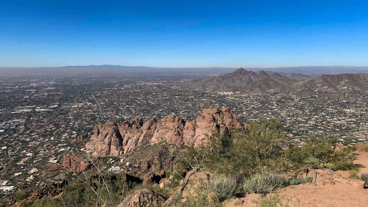
Camelback Mountain is the most popular mountain to hike in the Phoenix area for good reasons. It’s a fun challenging hike from either side, with good views of the Phoenix area, and entertaining to compare its profile to a napping camel. There are two popular routes up this dromedary. This route on the Echo Canyon Trail is the shorter, but steeper route of the two.

img
Trail Details
Summit Elevation:  2,707′
Distance: 2.4 miles
Time: 2 hours
Difficulty: Strenuous
Elevation gain: 1,400′
Dogs: No
When to go: Fall, Winter, Spring
Trail Hours: Sunrise to Sunset

Getting to the Trailhead

From Phoenix, get on highway 51 going North. Take exit 5 toward Lincoln Drive. Turn right onto E Glendale Ave, continue for about 4 miles, then turn right onto Tatum Blvd. Go half a mile on Tatum, then turn left onto E McDonald Drive. In just a few hundred feet you’ll come to a traffic circle and see the parking lot entrance on the right. Get turn-by-turn directions on Google Maps.

Entering Echo Canyon Trailhead Parking
Echo Canyon Trailhead

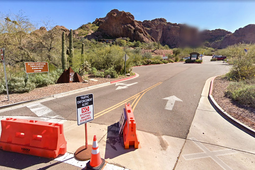
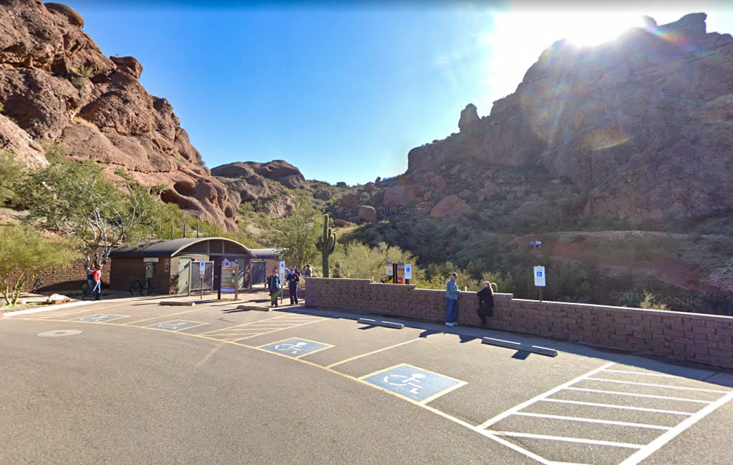
There is a parking attendant and gate, but parking is free. The large parking area does fill up fast, so make sure you get there early to snag a spot. Park in an available space, make sure you have plenty of water, and continue up to the top of the parking lot to find the trailhead. There are restrooms and water at the trailhead.

Hiking Camelback Mountain via Echo Canyon

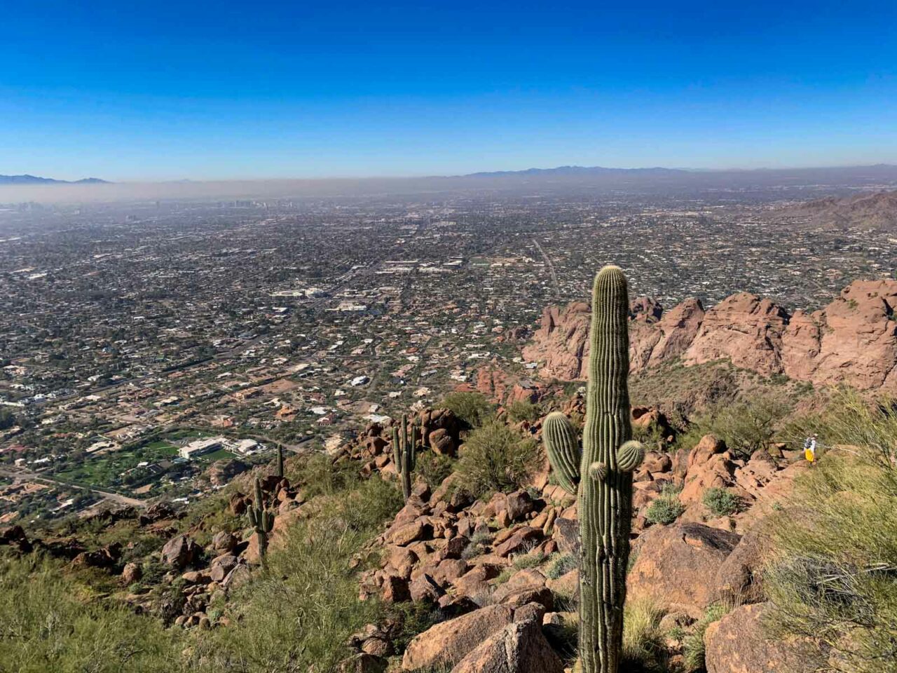
The trail begins from the top of the parking lot, just beyond the restrooms and benches. An easy incline at first, the path passes a smaller rock formation, then approaches the base of a larger one known as the “Praying Monk”. If you look up from the trail, you may see roped-up rock climbers scaling the face above you. And if you turn around and look the other way, you can see Piestewa Peak rising up behind you.

Looking up toward Camelback Mountain

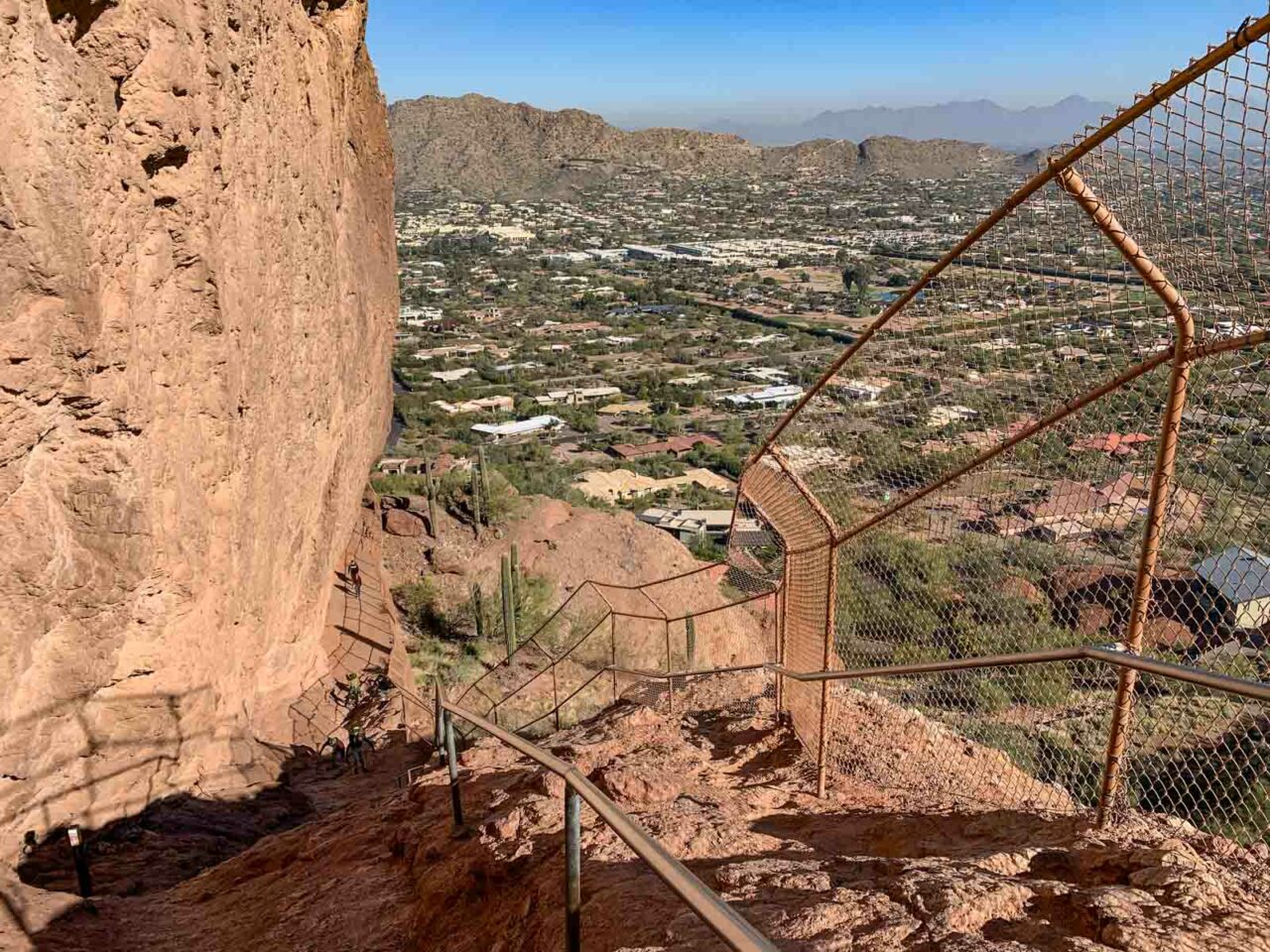
As you curve around the base of the rockface, the trail flattens, then goes nearly vertical! Fortunately there are railings and a fence to help, and there are steps worn in if you pick a good line.

Steep Section on Echo Canyon Trail

At the top of the excitingly steep section, the trail mellows again. You’ll soon pass the half-mile marker and wonder how you’ve only gone that far.

Half Mile Marker on Echo Canyon Trail

From here it’s a steady climb in the wash with some steep steps and light boulder-hopping.

Light boulder hopping on the Echo Canyon Trail

There is a small dip just before the one mile mark, then the trail rises steady and even steeper as it nears the summit. It’s easy to get a little off track in the last section – just keep looking for the path of least resistance.

Last Section before summit of Camelback Mountain

The trail makes one final bend to the left as it leads you to the top! Take in the awesome 360 degree view of the valley, with Piestewa closeby to the northwest. But make sure you pay attention to which way you came up – it’s easy to mistakenly go down the wrong trail. When you are done soaking in the views, return down the way you came up.

View from Camelback Mountain towards Piestewa Peak
Downtown Phoenix from Camelback Mountain
View towards downtown Phoenix
Heading back down the Echo Canyon Trail
Heading back down

Camelback Mountain via Echo Canyon Trail Map & Elevation Profile

© OpenStreetMap contributors
Download file: Camelback Mountain via Echo Canyon Trail.gpx


Camelback Mountain Hiking Resources

  • Overview of the Camelback Mountain Trails from Phoenix Parks and Recreation. Best resource for the latest information on closures, maintenance and other official notices.
  • Visit Phoenix’ guide to Camelback Mountain
  • Please #RecreateResponsibly and Leave No Trace

Arizona Six-Pack of Peaks Challenge – Winter Edition

2021 Arizona Winter Six-Pack of Peaks ChallengeThis hike is part of the Arizona Six-Pack of Peaks Challenge – Winter Edition. This self-paced hiking challenge includes six hikes all easily reached from the great Phoenix metropolitan area. They are a great way to explore the area, train for bigger adventures, and you’ll be doing good, with a portion of the net proceeds going to non-profits that help get youth outdoors.

Filed Under: Trail Guides Tagged With: Arizona, Camelback Mountain, peakbagging, Phoenix, Six-Pack of Peaks, strenuous

Like what you found here at SoCal Hiker? This site is a labor of love. Share your support for the site and help us development of new trail guides and expanded coverage -- make your next outdoor equipment purchase through our advertisers.

You can also subscribe to our weekly newsletter and follow us on Facebook or Twitter.

Richard O

About Richard Oppelaar

To me, hiking is a way to see the country in ways many people don’t. Road trips and collecting high points are my main motive. I grew up in New Jersey, discovered hiking while living in North Carolina, and have been based in Southern California since 2012. I love everything from hiking well maintained, popular trails in the Southwest to mountaineering less accessible peaks. My day job is teaching at a school where I’m lucky enough to have a small hiking club for students who I take on small excursions once a month.

Comments

  1. Trail Running Blog says

    February 1, 2021 at 3:53 pm

    I hiked this, oh maybe 15 years ago. I was travelling around the US. I was booked in a hostel in Pheonix but ended up moving to a Motel in Scottsdale. Pretty sure this was only round the corner from there. I remember I remember seeing the warning signs for mountain lions as I was heading up.

    Reply
  2. aol.com/mail says

    March 12, 2021 at 12:33 am

    For AOL Webmail is a free web-based email service that is provided by AOL mail. You can create an online address book for your important contacts through AOL Email service. To begin with the usage of AOL.

    Reply
  3. gianni@trailrunningshoes says

    September 23, 2021 at 3:59 am

    I’m from England, but hiked Camelback in about 2008 (when traveling the US). I’d recently moved out of a hostel in Phoenix and checked in to a Motel 6 which was pretty close the Camelback – No idea if it still exits or not.

    Reply

Leave a Reply Cancel reply

Your email address will not be published. Required fields are marked *

This site uses Akismet to reduce spam. Learn how your comment data is processed.

About SoCal Hiker

Jeff on Mount Rainier

I created SoCal Hiker while preparing to thru-hike the John Muir Trail. My goal? Create guides for the best hiking and backpacking trails with enough detail to make it an enjoyable experience for you. And while I started with trails in Southern California, I’ve expanded across the west. We hike each trail to create these guides, sharing practical advice on gear and outdoor skills. Read more…

Connect with SoCal Hiker

  • 22,757 Fans
  • 11,939 Followers
  • Followers
  • 1,719 Followers
  • 5,281 Subscribers
  • 341 Subscribers
SoCalHiker was selected one of USA TODAY's 10 Best Hiking and Outdoor Blogs
Get our day-by-day guide to thru-hiking the John Muir Trail
Get up-to-day wildfire status throughout California

Products

  • South Sister Benchmark South Sister Benchmark $39.95
  • Mt San Jacinto Mug Mt San Jacinto Mug $15.95
  • 2017 Six-Pack of Peaks Sticker 2017 Six-Pack of Peaks Sticker $3.00
  • Mt Shasta Benchmark Mount Shasta Benchmark $39.95

Sponsors

Sponsor SoCalHiker and see your banner here

Featured Posts

Backpacking the Grand Canyon of Tuolumne Loop in Yosemite National Park

Yosemite National P ark, and in particular Yosemite Valley, is home to some of the … [Read More...]

Hiking Belknap Crater in the Mountain Washington Wilderness

Hiking this out-and-back route up Belknap Crater you'll traverse an other-worldly … [Read More...]

Hiking to the Simpson Reef Overlook on the Oregon Coast Trail

The Oregon Coast is rugged, beautiful and often uncrowded. This bluff-top … [Read More...]

Lastest Comments

  • Amy Courtney on Ridgeline Trail
  • Jay Eleanor on Hiking to the Simpson Reef Overlook on the Oregon Coast Trail
  • Charles Krim on Hiking to the Simpson Reef Overlook on the Oregon Coast Trail
  • 11 Best California Bikepacking Routes | Wild Lumens on Inside Crystal Cove State Park
  • Ted Thed on Burbank Peak, Cahuenga Peak, Mt. Lee and the Hollywood Sign
Get your SoCalHiker stickers now

Get your SoCalHiker stickers!

Latest Posts

  • Backpacking the Grand Canyon of Tuolumne Loop in Yosemite National Park March 24, 2023
  • Hiking Belknap Crater in the Mountain Washington Wilderness October 20, 2022
  • Hiking to the Simpson Reef Overlook on the Oregon Coast Trail August 25, 2022
  • Join Team SoCalHiker at the Climb for Heroes August 23, 2022
  • Hiking the Welch-Dickey Loop in the White Mountain National Forest August 18, 2022

Recent Forum Topics

  • Lost Coast Trail
  • How to deal with accidents while hiking in the winter?
  • Warm Tips for your hiking in winter
  • Some tips for hiking.
  • Keep your body warm in the winter hiking

The Six-Pack of Peaks Challenge Series

Six-Pack of Peaks Challenge SeriesThe Six-Pack of Peaks Challenge Series gives you an opportunity to explore your world while supporting a great cause. There are eleven challenges around the country. Hike or run them at your own schedule.

Flex your adventure muscles!

Learn more here.


Search

Tags

3-6 miles 6-8 miles 8-10 miles 11+ miles Arizona Backpacking coastal dog-friendly easy family-friendly High Sierra Trail hiking Hiking The John Muir Trail hipster inspiration JMT John Muir John Muir Trail Kings Canyon National Park LA County moderate Mount Rainier National Park Muir Monday National Park Orange County Oregon out of bounds Pacific Crest Trail peak peakbagging quote scenic Sequoia National Park Sierra Nevada Six-Pack of Peaks State Park strenuous Thru-hiking Utah vista Washington waterfall wilderness Wonderland Trail Yosemite

Copyright © 2023 SoCalHiker.net · Metro Theme on Genesis Framework with WPEngine Hosting · Contact SoCal Hiker · Sitemap · Privacy Policy


Loading Comments...