• COVID-19 Park and Trail Closures
  • Learn about the Six-Pack of Peaks Challenge
  • Shop
  •  

SoCal Hiker

  • Find a Hiking Trail
    • All Areas
    • Arizona
    • Colorado
    • Los Angeles
    • Orange County
    • Oregon
    • San Francisco Bay
    • Washington
  • Trail Guides
  • Six-Pack of Peaks
    • Colorado Six-Pack of Peaks
      • Bergen Peak
      • Rocky Mountain
      • Birthday Peak
      • Horseshoe Mountain
      • Grays Peak
    • New England Six-Pack of Peaks
    • NorCal Six-Pack of Peaks
      • Mount Umunhum
      • Mount Saint Helena
      • Mount Tamalpais
      • Mount Diablo
      • Mount Sizer
      • Rose Peak
    • Oregon Six-Pack of Peaks
      • Tumalo Mountain
      • Black Butte
      • Black Crater
      • Maiden Peak
      • Mount Bachelor
      • South Sister
    • SoCal Six-Pack of Peaks
      • Mt. Wilson
      • Cucamonga Peak
      • Mt. San Antonio (Mt Baldy)
      • San Bernardino Peak
      • San Jacinto Peak
      • San Gorgonio
  • Backpacking
    • High Sierra Trail
    • John Muir Trail
      • Overview of the John Muir Trail
      • Training
      • Day-by-Day Itinerary
      • Resupply Addresses
      • JMT Discussion Forum
    • Lost Coast Trail
    • North/South Lake Loop
    • Rae Lakes Loop
    • Red Peak Pass Loop
    • Theodore Solomons Trail
    • Trans-Catalina Trail
    • Wonderland Trail
  • Gear
  • Forums
    • Latest Topics
    • Ask a Question
    • Campfire
    • Trails
    • Trail Reports
    • Gear Wisdom
    • Classifieds
  • Login

Baldwin Hills Scenic Overlook

September 29, 2013 By Jeff H 7 Comments

Baldwin-Hills-Overlook-at-Sunrise

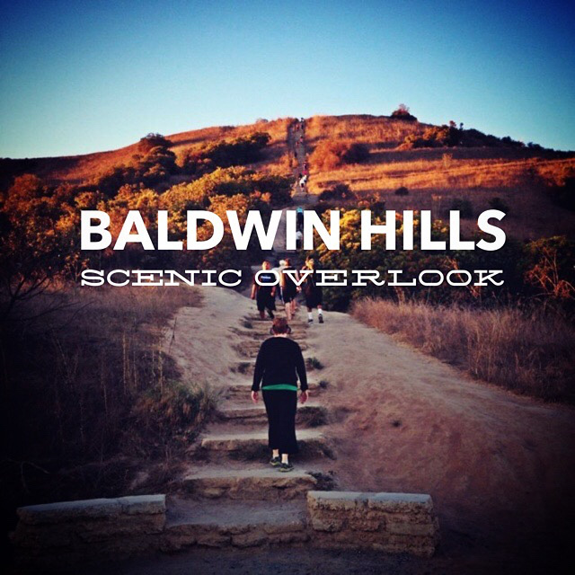
My gym is about 4 miles from home. And about 4 miles in the opposite direction is the Baldwin Hills Scenic Overlook. This tiny state park is notable mainly for a killer flight of stairs. I find it much more rewarding and satisfying than the StairMaster at the gym, with all the benefits of a stair climbing workout and the added perks of amazing views of Los Angeles — from the San Gabriel Mountains to the Pacific Ocean. And this short hike can be done at whatever pace you’re comfortable with. Some people run it. Some do multiple laps.

img
Trail Details
Distance: 1.5 miles
Time: 30 min.
Difficulty: Moderate
Elevation gain: 454 ft
Dogs: No
When to go: Year-round
This trail begins in Culver City on Jefferson Blvd. at Hetzler Road. There is a small parking lot that charges $6 to park, or free parking on the street. Be prepared to walk a bit, as the street parking gets very busy. And note that while there are no meters as of the date of writing, there are posts for meters, so they may be coming.

The trail itself is hard to miss. Right at street level you’ll see The World’s Most Clearly Marked Trailhead.

Baldwin Hills Overlook Trailhead

The trail heads up a switchback, bringing you to the foot of one, long staircase.

Stairs to Baldwin Hills Overlook

There are 282 steps to the top of the overlook. I should note that these “steps” are not normal steps. Some of them required that I lift my leg more than 90 degrees to step up. They are big steps, spread out.

At the top of the steps is an overlook with incredible views over Los Angeles. You get a clear shot of the San Gabriel Mountains, downtown LA, Hollywood, Westwood, all the way to the Pacific Ocean.

Baldwin Hills Outlook Panorama

A short side trip from the top takes you to a beautiful visitor center, which has restroom facilities and a native plant garden.

Baldwin Hills Overlook Visitor Center

Instead of taking the stairs down, save your knees! Retrace your steps to the observation deck then head to the east end. You’ll see a trail that snakes back and forth down the hill in a series of gentle switchbacks.

baldwin-hills-scenic-overlook-trail-map

With a side trip to the visitor center, this hike clocks in at about 1.5 miles. Going straight up the stairs and down the switchbacks it’s 1.3 miles. If you’re in the area, this is a great way to start your day. If you’re not in the area, you should swing by and check it out at least once. The stairs — and the views — are amazing.

Baldwin Hills Overlook Trail Map

© OpenStreetMap contributors
Download file: Baldwin-Hills-Overlook-Trail.gpx

Photo Gallery

Click on any photo to view a larger version. You can also leave comments on any photo.


Baldwin Hills Scenic Overlook Tips

  • Don’t cut the switchbacks. It speeds erosion.
  • There are restrooms at the top in the visitor center.
  • The park technically doesn’t open until 8am, but this seems to be routinely ignored.
  • Looking to reward your effort with breakfast? Check out S & W Country Diner in downtown Culver City.
  • Sorry, dogs are not allowed.

Baldwin Hills Scenic Overlook Resources

  • Baldwin Hills Scenic Overlook – official State Park web site

Culver City Weather Forecast

The location could not be found.

Filed Under: Trail Guides Tagged With: Baldwin Hills, Culver City, LA County, moderate

Like what you found here at SoCal Hiker? This site is a labor of love. Share your support for the site and help us development of new trail guides and expanded coverage -- make your next outdoor equipment purchase through our advertisers.

You can also subscribe to our weekly newsletter and follow us on Facebook or Twitter.

Jeff H

About Jeff H

I'm an avid hiker and backpacker. My wife Joan and I are on the trails every weekend. I started SoCal Hiker to share my passion for outdoor adventure.

Comments

  1. Jennifer says

    October 2, 2013 at 4:27 am

    Looks like a great hike and I agree, I’d rather do this than hit the gym.

    Reply
    • Jeff HJeff Hester says

      October 3, 2013 at 5:13 am

      Thanks, Jennifer. It’s a fun hill. The views are amazing. I’m looking forward to seeing what it’s like when the local mountains are covered in snow. I hear the views are beautiful! A clear view of downtown Los Angeles with snow-covered mountains in the background. Wow!

      Reply
  2. josh says

    October 3, 2013 at 2:52 pm

    That featured image is awesome!

    Reply
    • Jeff HJeff Hester says

      October 4, 2013 at 10:55 am

      Thanks, Josh. I’m looking forward to hitting that trail next time the San Gabriels are blanketed in snow. Should make for some amazing photos.

      Reply
  3. Nankie says

    December 29, 2013 at 10:47 pm

    Great post! I discovered this place about 6 months ago and just love it!

    Reply
  4. Alanna Brooke says

    July 23, 2016 at 7:44 pm

    Come by Baldwin Hills Scenic Overlook every Saturday until August 27th and do a free training prep run with Jose Zavala of Aztlan Athletics and get ready for ‪Conquer The Overlook‬!
    Meet at the top of the stair climb at the Aztlan Athletics booth.
    (We’ll also have DJ Denmaster to deliver tunes while you get your workout on.)

    Going on every Saturday until August 27th Free Training Prep Runs!
    -7:30am and 9:30am at Baldwin Hills Scenic Outlook.
    -Two start times: @730am and @930am
    -Raffle @1030am for a FREE registration for Conquer The Overlook
    -OR-
    Go online http://www.conquertheoverlook.com and register today with promo code: gameon and save $10.00 on registration

    Address:

    6300 Hetzler Rd., Culver City, California 90232, Culver City, CA

    Description:
    The Conquer The Overlook Climb 282 is coming back to the historic state park “Baldwin Hills Overlook”, Culver City!

    All You Can Eat Gourmet Tacos Included* (*while supplies last)
    2 Free Beers included per person in the Beer Garden
    DJ Music and Entertainment
    Dance and Chill Under The Stars
    Official Race Results will be posted for online viewing.
    All participants will be able to access resource agencies, health & wellness, and specialty booths.
    Commemorative T-Shirt guaranteed to pre-registered only! All others while supplies last.

    Reply
  5. Luis SLuis S says

    February 16, 2017 at 9:49 am

    Going for the first time this Sunday coming up, Super Excited.
    I am more of a more intense hiker but Ive heard that this place is beautiful so anything as long as I get to be where I feel most alive….. OUTSIDE

    Reply

Leave a Reply Cancel reply

Your email address will not be published. Required fields are marked *

This site uses Akismet to reduce spam. Learn how your comment data is processed.

About SoCal Hiker

Jeff on Mount Rainier

I created SoCal Hiker while preparing to thru-hike the John Muir Trail. My goal? Create guides for the best hiking and backpacking trails with enough detail to make it an enjoyable experience for you. And while I started with trails in Southern California, I’ve expanded across the west. We hike each trail to create these guides, sharing practical advice on gear and outdoor skills. Read more…

Connect with SoCal Hiker

  • 22,735 Fans
  • 11,941 Followers
  • 21,640 Followers
  • 1,717 Followers
  • 5,275 Subscribers
  • 338 Subscribers
SoCalHiker was selected one of USA TODAY's 10 Best Hiking and Outdoor Blogs
Get our day-by-day guide to thru-hiking the John Muir Trail
Get up-to-day wildfire status throughout California

Products

  • Mount Wilson T-Shirt $23.00 – $27.00
  • San Bernardino Peak T-Shirt $23.00 – $25.00
  • The SoCalHiker patch can be sewn or ironed-on. SoCal Hiker Patch $5.00
  • 2017 Six-Pack of Peaks Sticker 2017 Six-Pack of Peaks Sticker $3.00

Sponsors

Sponsor SoCalHiker and see your banner here

Featured Posts

Hiking Belknap Crater in the Mountain Washington Wilderness

Hiking this out-and-back route up Belknap Crater you'll traverse an other-worldly … [Read More...]

Hiking to the Simpson Reef Overlook on the Oregon Coast Trail

The Oregon Coast is rugged, beautiful and often uncrowded. This bluff-top … [Read More...]

Join Team SoCalHiker at the Climb for Heroes

Team SoCalHiker is climbing Mount Baldy again as part of the annual Climb for Heroes … [Read More...]

Lastest Comments

  • Greg on Rae Lakes Loop via Kearsarge Pass
  • Tim Wilson on Rae Lakes Loop via Kearsarge Pass
  • Pam Selthun on Backpacking the Wonderland Trail
  • Calico Maps on Hiking Monserate Mountain
  • Deborah Aguanno on Mt. Wilson via Chantry Flats
Get your SoCalHiker stickers now

Get your SoCalHiker stickers!

Latest Posts

  • Hiking Belknap Crater in the Mountain Washington Wilderness October 20, 2022
  • Hiking to the Simpson Reef Overlook on the Oregon Coast Trail August 25, 2022
  • Join Team SoCalHiker at the Climb for Heroes August 23, 2022
  • Hiking the Welch-Dickey Loop in the White Mountain National Forest August 18, 2022
  • Hiking Turtlehead Peak from Red Rock Canyon National Conservation Area July 15, 2022

Recent Forum Topics

  • How to deal with accidents while hiking in the winter?
  • Warm Tips for your hiking in winter
  • Some tips for hiking.
  • Keep your body warm in the winter hiking
  • The benefits of hiking, more than you can imagine!

The Six-Pack of Peaks Challenge Series

Six-Pack of Peaks Challenge SeriesThe Six-Pack of Peaks Challenge Series gives you an opportunity to explore your world while supporting a great cause. There are eleven challenges around the country. Hike or run them at your own schedule.

Flex your adventure muscles!

Learn more here.


Search

Tags

3-6 miles 6-8 miles 8-10 miles 11+ miles Arizona Backpacking coastal dog-friendly easy family-friendly High Sierra Trail hiking Hiking The John Muir Trail hipster inspiration JMT John Muir John Muir Trail Kings Canyon National Park LA County moderate Mount Rainier National Park Muir Monday National Park Orange County Oregon out of bounds Pacific Crest Trail peak peakbagging quote scenic Sequoia National Park Sierra Nevada Six-Pack of Peaks State Park strenuous Thru-hiking Utah vista Washington waterfall wilderness Wonderland Trail Yosemite

Copyright © 2023 SoCalHiker.net · Metro Theme on Genesis Framework with WPEngine Hosting · Contact SoCal Hiker · Sitemap · Privacy Policy


Loading Comments...