• COVID-19 Park and Trail Closures
  • Learn about the Six-Pack of Peaks Challenge
  • Shop
  •  

SoCal Hiker

  • Find a Hiking Trail
    • All Areas
    • Arizona
    • Colorado
    • Los Angeles
    • Orange County
    • Oregon
    • San Francisco Bay
    • Washington
  • Trail Guides
  • Six-Pack of Peaks
    • Colorado Six-Pack of Peaks
      • Bergen Peak
      • Rocky Mountain
      • Birthday Peak
      • Horseshoe Mountain
      • Grays Peak
    • New England Six-Pack of Peaks
    • NorCal Six-Pack of Peaks
      • Mount Umunhum
      • Mount Saint Helena
      • Mount Tamalpais
      • Mount Diablo
      • Mount Sizer
      • Rose Peak
    • Oregon Six-Pack of Peaks
      • Tumalo Mountain
      • Black Butte
      • Black Crater
      • Maiden Peak
      • Mount Bachelor
      • South Sister
    • SoCal Six-Pack of Peaks
      • Mt. Wilson
      • Cucamonga Peak
      • Mt. San Antonio (Mt Baldy)
      • San Bernardino Peak
      • San Jacinto Peak
      • San Gorgonio
  • Backpacking
    • High Sierra Trail
    • John Muir Trail
      • Overview of the John Muir Trail
      • Training
      • Day-by-Day Itinerary
      • Resupply Addresses
      • JMT Discussion Forum
    • Lost Coast Trail
    • North/South Lake Loop
    • Rae Lakes Loop
    • Red Peak Pass Loop
    • Theodore Solomons Trail
    • Trans-Catalina Trail
    • Wonderland Trail
  • Gear
  • Forums
    • Latest Topics
    • Ask a Question
    • Campfire
    • Trails
    • Trail Reports
    • Gear Wisdom
    • Classifieds
  • Login

The Muir Taco Adventure – 2015 Edition

June 14, 2018 By Jeff H Leave a Comment

The Second Annual Muir Taco Adventure

We peered up at the ridge above the cirque, straining to find Lamarck Col. Checking our maps and double-checking the GPS, we found what looked like a playground of car-sized boulders. The silhouette of a lone backpacker sitting at the top confirmed our suspicions — our route was going to involve some scrambling. Little did we know that the other side of the ridge would be even tougher. And it was only our second day on the second annual Muir Taco Adventure.

On the first Muir Taco Adventure, we packed in beer, grilled carne asada, tortillas, cheese, avocados and salsa over Bishop Pass. Our goal was to serve thru-hikers on the 211-mile John Muir Trail from Muir Hut on Muir Pass, but with one of our team members was hobbled by a nagging foot injury, so we opted instead to setup our pop-up taco stand at the Muir Monster.

This year, we had the same objective, but via a shorter but more challenging route to Muir Pass, heading over Lamarck Col. This route from the North Lake trailhead outside of Bishop begins as an established trail, but dissolves into a boulder-hopping, route finding trip over the col and down to the amazing views of Darwin Bench before finally joining the John Muir Trail near Evolution Lake. From there we planned to head south to Muir Pass, down into Le Conte Canyon, and finally up to Dusy Basin, over Bishop Pass and out to South Lake. It was a solid plan, until the wildfires came along.

There were four of us for this year’s mission. I was joined by three Muir Taco newbies: Paul, Mark and Byron. We drove up the 395 from LA to Bishop, picked up our permit, then parked one car at South Lake (our exit trailhead) and my Xterra at North Lake. With a mid-afternoon start, our plan for day one was an easy hike up to Lamarck Lake.

Left to Right: Jeff, Paul, Mark and Byron
Pre-hike show of the crew
Looking back as we climb higher toward Lower Lamarck Lake
The skies on the eastern side of the divide were smoky
Smoky skies on the east side of the Sierra Nevada divide
Looking down at Grass Lake
Lower Lamarck Lake
Lower Lamarck Lake

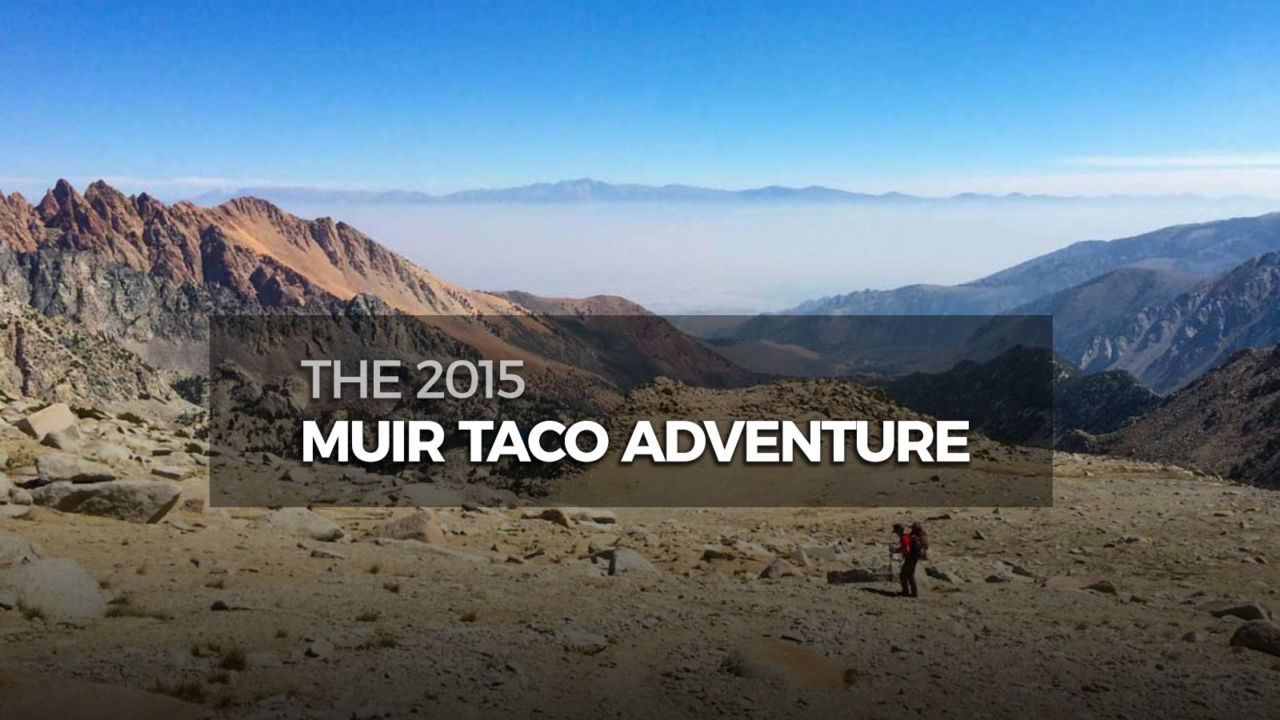
The next morning, we arose at sunrise. After the requisite coffee and oatmeal, we broke camp and headed toward Lamarck Col. The trail to the col is less-traveled and sometimes picking the route takes some detective work. The views to the east opened up as we climbed above the tree-line, and soon we approached the cirque.

Early morning at our first camp
Sunrise from camp
The lunar landscape above Upper Lamarck Lake
Climbing above the tree-line
Smoke filled valley along Highway 395
Looking back down toward Bishop
Pushing up sandy loam to the cirque
Slog to Lamarck Col
The col is here... somewhere
The col is dead center, and a scramble
Looking back down from Lamarck Col
Looking back down from the Col

We had some discussion about where exactly the col was. There wasn’t a clear “trail” that led up. It was going to be a boulder scramble to the crest of the col. Finally, we spied a single person standing at the divide next to the trail sign marking the entrance to Kings Canyon National Park. We began carefully climbing from boulder to boulder up to the top of the col.

Smoke from the Rough Fire made this even more difficult.

When we reached the crest, we quickly realized two things. First, the smoke from the Rough Fire was far worse than we anticipated. It was certain to be a factor in this trip. Second, getting down the west side of the col would be even more arduous than climbing the east side.

There is no “trail” down from Lamarck Col. It’s another boulder scramble. Every now and then you run across a short social trail, but it soon gives way to another boulder field and you’re stuck picking your way down to the bottom of the basin. Carrying extra heavy loads with taco ingredients (and beer) doesn’t help.

Heading down into Darwin Canyon
Fragments of social trails disappear into boulder fields
Our "trail" down into Darwin Canyon
Look closely and you may find Paul making his way down into Darwin Canyon from Lamarck Col.
It's marginally easier once you reach the chain of lakes

Our goal had been to setup camp near the outlet of Evolution Lake on the JMT. Unfortunately, we got some bad news. As we neared Darwin Bench, we ran across a former ranger traveling in the opposite direction. He had just met up with rangers earlier in the day and was told that they were considering closing Muir Pass and even evacuating the ranger station in Le Conte Canyon due to wildfire danger. The Rough Fire was wreaking havoc.

Exhausted from the long, slow slog over and down the col, we decided to camp at Darwin Bench and reassess our plans.

Byron still smiling
Still smiling
Evening light from our camp at Darwin Bench
View from our camp
First course? Ramen.
Paul cooks dinner.

Darwin Bench is a beautiful place to camp. Being off and above the JMT/PCT corridor, we had the place to ourselves.

After a decent night’s sleep, we considered our options around breakfast. We quickly ruled out our original plan to head over Muir Pass. The smoke had partially dissipated overnight, but we had recognized that as part of the pattern, and knew it would grow worse over the day. We could turn around and go back over Lamarck Col. With the memory of that fresh, we quickly ruled that option out as well. Our third option was to hike through Evolution Valley down to Goddard Canyon, then up Piute Creek, over Piute Pass and back to North Lake. We could still setup our “taco stand” in McClure Meadow. It was settled.

Morning at Darwin Bench
Making our way down to the JMT
Heading toward McClure Meadow
Colby Meadow

On our way down to McClure Meadow, we ran into a couple of JMT hikers who were continuing southbound in spite of the fire. We wished them well and handed them a beer for later. If nothing else, it would help clear the smoke out of their throats.

McClure Meadow had a great campsite for us to setup our taco production. We were right near the trail, so we could easily see and call out to any passing thru-hikers. Plus, we had a banner.

We setup production, heating the carne asada, making guacamole, and cooling the beer in the nearby creek. And soon we had hikers.

Mark prepping fresh guacamole
Setting up the kitchen
Cerveza to wash down the tacos
…and the bar
Happy JMT thru-hikers
Mark, Zach, Mark, Byron, Paul
Happy campers
Tacos and beer. What’s not to love?

I’ll never get tired of the expressions of pure joy they share when they realize it’s not a joke – we really are offering them a free, freshly made taco and beer. And of course, one of the beautiful things about long distance backpacking is that you can always eat. Your body typically runs a caloric deficit, so more food just staves off the hunger.

My favorite story came when a group of college-age thru-hikers from east coast came by. One of them asked me “Are you the guy from SoCalHiker?! You’re the reason I’m hiking the JMT!” He shared how he’d spend time in class reading and re-reading my posts on the John Muir Trail. I’m hoping it didn’t stop him from graduating, but thrilled that he was inspired. “I bring fresh tacos and beer to all my readers,” I joked. It was a happy accident to run into him.

We shared a couple tacos with the ranger from McClure Meadow Station, and then packed up our gear and hit the trail again. This time, our plan was to camp along the San Joaquin River, near the northern boundary of Kings Canyon National Park.

Crossing Evolution Creek
Smoky skies on our way into Goddard Canyon
Crossing the San Joaquin
Byron on the South Fork of the San Joaquin
Still smoky at sunset on the San Joaquin

Waking after our third night, we broke camp and soon left Kings Canyon NP. Here we parted from the JMT and PCT and headed up toward Piute Pass. I had never been up this route, and wasn’t sure what to expect. As it turns out, it’s quite beautiful!

The Crew of the 2nd Annual Muir Taco Adventure
Morning Light at the Junction with the Piute Trail
Earless Yoda at the Northern Boundary of Kings Canyon NP
Paul Thinking About the Piute Trail
Just a Typical Scene on Piute Creek
Smoke, Not Clouds
There were no clouds in the sky, just smoke from the Rough Fire. Smelled like a campfire all day long.

As was the pattern, the day began with optimistically blue skies, but almost like clockwork, the afternoon sun was choked with smoke. As we climbed higher toward the pass, smoke filled the entire basin. It was like breathing a campfire. Not good.

You can barely make out the outline of the mountains in the distance thanks to the smoke from the Rough Fire.
Paul in Summit Lake
Camp just west of Piute Pass

We camped for the night just below Piute Pass. It was a long haul, and this set us up well for a short hike out to the trailhead. The smoke was so thick that you could barely make out the outlines of the jagged peaks towering around us.

Our fifth and final day, we climbed over Piute Pass and enjoyed the slightly clearer morning air as we hiked back down to North Lake.

Headed Down to North Lake from Piute Pass

This modified route worked well for us. It was a little longer than our original plan, but with the same number of nights, we had plenty of food. As it turns out, we came out at North Lake, near where we started five days earlier. We still had to go pickup the other car at South Lake, but we didn’t have to hitch a ride.

The Rough Fire may have wreaked havoc on our plans to serve tacos at Muir Pass, but it didn’t stop us from our core mission: bringing a little trail magic to hungry and thirsty thru-hikers, deep in the backcountry. And that is priceless.

Postscript

Señor Muir’s Taco Hut has it’s own Facebook page. Follow along for more photos from other Muir Taco adventures.

Originally hiked on August 20-24, 2015. Thanks to Paul, Mark and Byron for joining me on this bodacious boondoggle! 

Filed Under: Hiking News, Lifestyle Tagged With: Backpacking, JMT, Kings Canyon National Park, Lamarck, Lamarck Col, McClure Meadow, MuirTaco, PCT, Piute Pass, trail magic

Like what you found here at SoCal Hiker? This site is a labor of love. Share your support for the site and help us development of new trail guides and expanded coverage -- make your next outdoor equipment purchase through our advertisers.

You can also subscribe to our weekly newsletter and follow us on Facebook or Twitter.

Jeff H

About Jeff H

I'm an avid hiker and backpacker. My wife Joan and I are on the trails every weekend. I started SoCal Hiker to share my passion for outdoor adventure.

Leave a Reply Cancel reply

Your email address will not be published. Required fields are marked *

This site uses Akismet to reduce spam. Learn how your comment data is processed.

About SoCal Hiker

Jeff on Mount Rainier

I created SoCal Hiker while preparing to thru-hike the John Muir Trail. My goal? Create guides for the best hiking and backpacking trails with enough detail to make it an enjoyable experience for you. And while I started with trails in Southern California, I’ve expanded across the west. We hike each trail to create these guides, sharing practical advice on gear and outdoor skills. Read more…

Connect with SoCal Hiker

  • 22,751 Fans
  • 11,945 Followers
  • Followers
  • 1,717 Followers
  • 5,281 Subscribers
  • 342 Subscribers
SoCalHiker was selected one of USA TODAY's 10 Best Hiking and Outdoor Blogs
Get our day-by-day guide to thru-hiking the John Muir Trail
Get up-to-day wildfire status throughout California

Products

  • Mt San Jacinto Benchmark $39.95
  • Mount San Jacinto T-Shirt $23.00 – $25.00
  • 2017 Women's Six-Pack of Peaks Racerback Tank $27.00
  • Six-Pack of Peaks Patch for 2016 2016 Six-Pack of Peaks Patch $6.00

Sponsors

Sponsor SoCalHiker and see your banner here

Featured Posts

Hiking Belknap Crater in the Mountain Washington Wilderness

Hiking this out-and-back route up Belknap Crater you'll traverse an other-worldly … [Read More...]

Hiking to the Simpson Reef Overlook on the Oregon Coast Trail

The Oregon Coast is rugged, beautiful and often uncrowded. This bluff-top … [Read More...]

Join Team SoCalHiker at the Climb for Heroes

Team SoCalHiker is climbing Mount Baldy again as part of the annual Climb for Heroes … [Read More...]

Lastest Comments

  • Amy Courtney on Ridgeline Trail
  • Jay Eleanor on Hiking to the Simpson Reef Overlook on the Oregon Coast Trail
  • Charles Krim on Hiking to the Simpson Reef Overlook on the Oregon Coast Trail
  • 11 Best California Bikepacking Routes | Wild Lumens on Inside Crystal Cove State Park
  • Ted Thed on Burbank Peak, Cahuenga Peak, Mt. Lee and the Hollywood Sign
Get your SoCalHiker stickers now

Get your SoCalHiker stickers!

Latest Posts

  • Hiking Belknap Crater in the Mountain Washington Wilderness October 20, 2022
  • Hiking to the Simpson Reef Overlook on the Oregon Coast Trail August 25, 2022
  • Join Team SoCalHiker at the Climb for Heroes August 23, 2022
  • Hiking the Welch-Dickey Loop in the White Mountain National Forest August 18, 2022
  • Hiking Turtlehead Peak from Red Rock Canyon National Conservation Area July 15, 2022

Recent Forum Topics

  • How to deal with accidents while hiking in the winter?
  • Warm Tips for your hiking in winter
  • Some tips for hiking.
  • Keep your body warm in the winter hiking
  • The benefits of hiking, more than you can imagine!

The Six-Pack of Peaks Challenge Series

Six-Pack of Peaks Challenge SeriesThe Six-Pack of Peaks Challenge Series gives you an opportunity to explore your world while supporting a great cause. There are eleven challenges around the country. Hike or run them at your own schedule.

Flex your adventure muscles!

Learn more here.


Search

Tags

3-6 miles 6-8 miles 8-10 miles 11+ miles Arizona Backpacking coastal dog-friendly easy family-friendly High Sierra Trail hiking Hiking The John Muir Trail hipster inspiration JMT John Muir John Muir Trail Kings Canyon National Park LA County moderate Mount Rainier National Park Muir Monday National Park Orange County Oregon out of bounds Pacific Crest Trail peak peakbagging quote scenic Sequoia National Park Sierra Nevada Six-Pack of Peaks State Park strenuous Thru-hiking Utah vista Washington waterfall wilderness Wonderland Trail Yosemite

Copyright © 2023 SoCalHiker.net · Metro Theme on Genesis Framework with WPEngine Hosting · Contact SoCal Hiker · Sitemap · Privacy Policy


Loading Comments...