• COVID-19 Park and Trail Closures
  • Learn about the Six-Pack of Peaks Challenge
  • Shop
  •  

SoCal Hiker

  • Find a Hiking Trail
    • All Areas
    • Arizona
    • Colorado
    • Los Angeles
    • Orange County
    • Oregon
    • San Francisco Bay
    • Washington
  • Trail Guides
  • Six-Pack of Peaks
    • Colorado Six-Pack of Peaks
      • Bergen Peak
      • Rocky Mountain
      • Birthday Peak
      • Horseshoe Mountain
      • Grays Peak
    • New England Six-Pack of Peaks
    • NorCal Six-Pack of Peaks
      • Mount Umunhum
      • Mount Saint Helena
      • Mount Tamalpais
      • Mount Diablo
      • Mount Sizer
      • Rose Peak
    • Oregon Six-Pack of Peaks
      • Tumalo Mountain
      • Black Butte
      • Black Crater
      • Maiden Peak
      • Mount Bachelor
      • South Sister
    • SoCal Six-Pack of Peaks
      • Mt. Wilson
      • Cucamonga Peak
      • Mt. San Antonio (Mt Baldy)
      • San Bernardino Peak
      • San Jacinto Peak
      • San Gorgonio
  • Backpacking
    • High Sierra Trail
    • John Muir Trail
      • Overview of the John Muir Trail
      • Training
      • Day-by-Day Itinerary
      • Resupply Addresses
      • JMT Discussion Forum
    • Lost Coast Trail
    • North/South Lake Loop
    • Rae Lakes Loop
    • Red Peak Pass Loop
    • Theodore Solomons Trail
    • Trans-Catalina Trail
    • Wonderland Trail
  • Gear
  • Forums
    • Latest Topics
    • Ask a Question
    • Campfire
    • Trails
    • Trail Reports
    • Gear Wisdom
    • Classifieds
  • Login

Hiking to McWay Falls in Big Sur

December 22, 2015 By Jeff H 6 Comments

Photogenic McWay Falls in Big Sur

McWay Falls is “that” waterfall in Big Sur that everyone has seen and many have photographed. I had driven up and down Big Sur several times before I finally made a point of going here. It was on my “must-see” list for years, but I just hadn’t timed my drive right… until this year.

img
Trail Details
Distance: 0.5 miles
Time: 10 min.
Difficulty: Easy
Elevation gain: 50 ft
Dogs: No
When to go: Year-round
The “hike” to McWay Falls is really just a casual stroll on a mostly paved trail. It’s no more than half a mile, and only when you include the weave and bob around the crowds. But it’s well worth it. McWay Falls is one of the most scenic, most photographed views in Big Sur. The waterfall from McWay Creek spills directly onto the beach. The color of the water can be surreal. The jagged rocks; the surging ocean; the coastal forest all converge and magic happens.

The best place to get to McWay Falls is from Falls Trail just past the entrance to Julia Pfeiffer Burns State Park. You’ll pay a day use fee to park here, but the Falls Trail goes under Pacific Coast Highway via a tunnel, making it a safer option than jockeying for a parking spot along busy Highway 1.

The Falls Trail takes you to epic McWay Falls in Big Sur

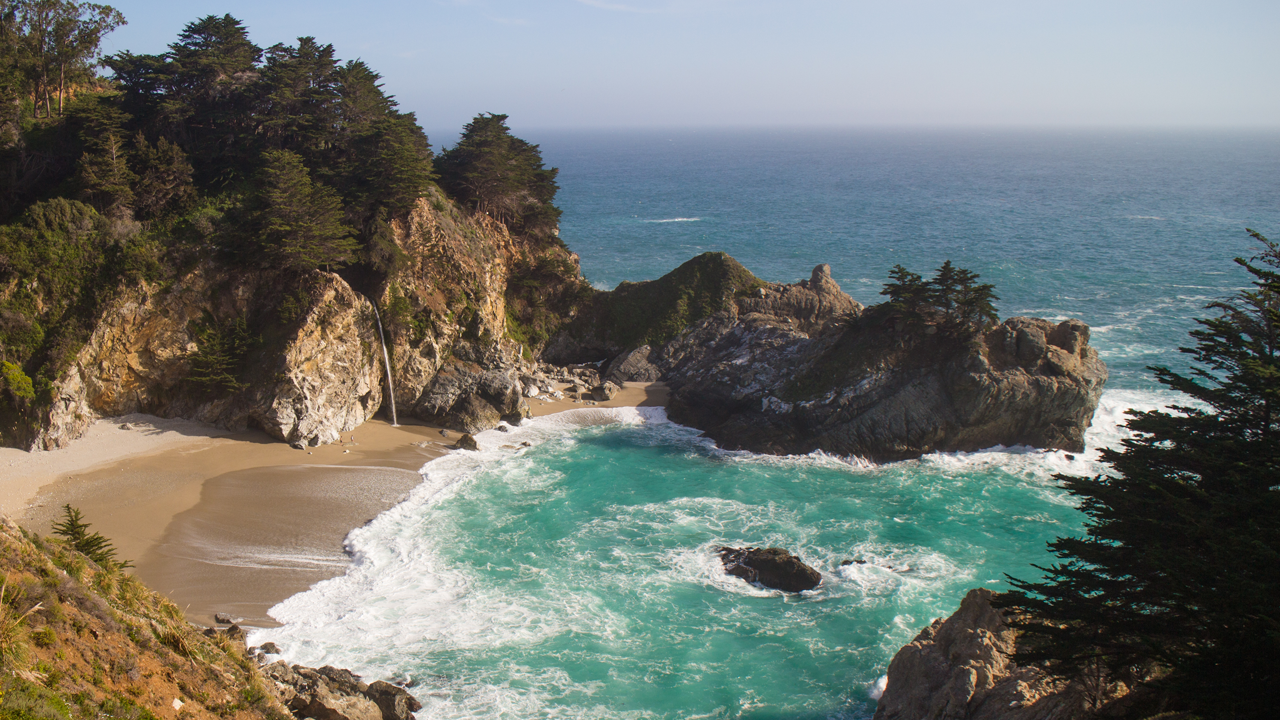
Once you pass through the tunnel, you wind your way along the top of the bluff to the right. You’ll see great views of McWay Falls, where the water from McWay Creek spills 80 feet down, directly onto the beach.

Interestingly, that beach didn’t always exist.

In 1983, a huge landslide just north of the cove dumped massive amounts of dirt and silt into the ocean. Pacific Coast Highway was closed for nearly a year as crews worked to clear the slide and stabilize the hills. The cove, which used to be filled entirely with sea water, was filled with sand and sediment that washed up as a result of the landslide.

The overlook itself is the terrace from what used to be the Waterfall House — a vacation residence of Lathrop and Helen Hooper Brown. The ranch was donated to the state on the condition that it be preserved for a state park — dedicated to Julia Pfeiffer Burns — one of the pioneer women of Big Sur.

Standing there on the terrace, it’s hard to imagine a more idyllic bedroom view.

McWay Falls Trail Map

© OpenStreetMap contributors
Download file: mcway-falls.gpx

McWay Falls Tips

  • Visit later in the afternoon for best the best light
  • Don’t ignore the signs warning you to NOT climb down the cliff to the beach. It accelerates erosion and could lead to further access restrictions. Lead by your example.
  • Many people park on the side of Highway 1, but avoid the risk by parking on the east side in the state park’s parking lot. You’ll have to pay a few bucks, but you have a scenic tunnel that takes you safely and directly to the fall overlook.
  • In December and January, the overlook is a good place to watch for gray whales migrating southward to the calving grounds off the Baja California coast. You can see them return northward in March and April.
  • There are bathrooms available inside the state park on the east side of PCH.

More Julia Pfeiffer Burns State Park Resources

  • Take time to hike the Ewoldsen Trail on the “other” side of PCH.
  • Official Julia Pfeiffer Burns State Park Brochure (PDF)
  • Julia Pfeiffer Burns State Park (official website)

Julia Pfeiffer Burns State Park Weather Forecast

The location could not be found.

Filed Under: State Parks, Trail Guides Tagged With: Big Sur, coastal, easy, family-friendly, State Park, vista, waterfall

Like what you found here at SoCal Hiker? This site is a labor of love. Share your support for the site and help us development of new trail guides and expanded coverage -- make your next outdoor equipment purchase through our advertisers.

You can also subscribe to our weekly newsletter and follow us on Facebook or Twitter.

Jeff H

About Jeff H

I'm an avid hiker and backpacker. My wife Joan and I are on the trails every weekend. I started SoCal Hiker to share my passion for outdoor adventure.

Comments

  1. soulrunner74 says

    December 23, 2015 at 12:19 am

    Nice Track
    Thank you 🙂

    Reply
  2. Joe says

    May 10, 2016 at 8:14 am

    Avoid paying the day use fee by camping in one of the nearby state parks. Your camping fees give you access to any state park on any day you’ve paid overnight fees. This is a great trip to do on the way back to so Cal from Pfeiffer Big Sur state park.

    Reply
    • Theresa Eychaner says

      June 20, 2020 at 11:48 am

      Is there a link where of a cwrtain place where I can camp over night to hike falls.

      Reply
  3. Steve Perez says

    June 27, 2019 at 8:19 am

    Can you swim at the beach by the McWay Falls?

    Reply
  4. Bob says

    December 2, 2019 at 3:38 pm

    Very nice article. Beautiful and encouraging to try to visit early next year, especially my wife and I who aren’t hikers. Very easy access. Thanks for the opportunity to explore. Saw a picture of the area at a motel in South Lake Tahoe. Tahoe Beach and Yacht Club.

    Reply
  5. Eliza says

    July 19, 2021 at 11:09 am

    Do you know if this ‘hike’ to the falls is stroller-friendly? Thanks for this great information!

    Reply

Leave a Reply Cancel reply

Your email address will not be published. Required fields are marked *

This site uses Akismet to reduce spam. Learn how your comment data is processed.

About SoCal Hiker

Jeff on Mount Rainier

I created SoCal Hiker while preparing to thru-hike the John Muir Trail. My goal? Create guides for the best hiking and backpacking trails with enough detail to make it an enjoyable experience for you. And while I started with trails in Southern California, I’ve expanded across the west. We hike each trail to create these guides, sharing practical advice on gear and outdoor skills. Read more…

Connect with SoCal Hiker

  • 22,757 Fans
  • 11,939 Followers
  • Followers
  • 1,719 Followers
  • 5,281 Subscribers
  • 341 Subscribers
SoCalHiker was selected one of USA TODAY's 10 Best Hiking and Outdoor Blogs
Get our day-by-day guide to thru-hiking the John Muir Trail
Get up-to-day wildfire status throughout California

Products

  • Mount Wilson T-Shirt $23.00 – $27.00
  • Mt Baldy Mug Mt San Antonio (Mt Baldy) Mug $15.95
  • Mt Shasta Benchmark Mount Shasta Benchmark $39.95
  • #MuirTaco stickers Muir Taco Stickers (2-pack) $3.00

Sponsors

Sponsor SoCalHiker and see your banner here

Featured Posts

Backpacking the Grand Canyon of Tuolumne Loop in Yosemite National Park

Yosemite National P ark, and in particular Yosemite Valley, is home to some of the … [Read More...]

Hiking Belknap Crater in the Mountain Washington Wilderness

Hiking this out-and-back route up Belknap Crater you'll traverse an other-worldly … [Read More...]

Hiking to the Simpson Reef Overlook on the Oregon Coast Trail

The Oregon Coast is rugged, beautiful and often uncrowded. This bluff-top … [Read More...]

Lastest Comments

  • Amy Courtney on Ridgeline Trail
  • Jay Eleanor on Hiking to the Simpson Reef Overlook on the Oregon Coast Trail
  • Charles Krim on Hiking to the Simpson Reef Overlook on the Oregon Coast Trail
  • 11 Best California Bikepacking Routes | Wild Lumens on Inside Crystal Cove State Park
  • Ted Thed on Burbank Peak, Cahuenga Peak, Mt. Lee and the Hollywood Sign
Get your SoCalHiker stickers now

Get your SoCalHiker stickers!

Latest Posts

  • Backpacking the Grand Canyon of Tuolumne Loop in Yosemite National Park March 24, 2023
  • Hiking Belknap Crater in the Mountain Washington Wilderness October 20, 2022
  • Hiking to the Simpson Reef Overlook on the Oregon Coast Trail August 25, 2022
  • Join Team SoCalHiker at the Climb for Heroes August 23, 2022
  • Hiking the Welch-Dickey Loop in the White Mountain National Forest August 18, 2022

Recent Forum Topics

  • Lost Coast Trail
  • How to deal with accidents while hiking in the winter?
  • Warm Tips for your hiking in winter
  • Some tips for hiking.
  • Keep your body warm in the winter hiking

The Six-Pack of Peaks Challenge Series

Six-Pack of Peaks Challenge SeriesThe Six-Pack of Peaks Challenge Series gives you an opportunity to explore your world while supporting a great cause. There are eleven challenges around the country. Hike or run them at your own schedule.

Flex your adventure muscles!

Learn more here.


Search

Tags

3-6 miles 6-8 miles 8-10 miles 11+ miles Arizona Backpacking coastal dog-friendly easy family-friendly High Sierra Trail hiking Hiking The John Muir Trail hipster inspiration JMT John Muir John Muir Trail Kings Canyon National Park LA County moderate Mount Rainier National Park Muir Monday National Park Orange County Oregon out of bounds Pacific Crest Trail peak peakbagging quote scenic Sequoia National Park Sierra Nevada Six-Pack of Peaks State Park strenuous Thru-hiking Utah vista Washington waterfall wilderness Wonderland Trail Yosemite

Copyright © 2023 SoCalHiker.net · Metro Theme on Genesis Framework with WPEngine Hosting · Contact SoCal Hiker · Sitemap · Privacy Policy


Loading Comments...