• COVID-19 Park and Trail Closures
  • Learn about the Six-Pack of Peaks Challenge
  • Shop
  •  

SoCal Hiker

  • Find a Hiking Trail
    • All Areas
    • Arizona
    • Colorado
    • Los Angeles
    • Orange County
    • Oregon
    • San Francisco Bay
    • Washington
  • Trail Guides
  • Six-Pack of Peaks
    • Colorado Six-Pack of Peaks
      • Bergen Peak
      • Rocky Mountain
      • Birthday Peak
      • Horseshoe Mountain
      • Grays Peak
    • New England Six-Pack of Peaks
    • NorCal Six-Pack of Peaks
      • Mount Umunhum
      • Mount Saint Helena
      • Mount Tamalpais
      • Mount Diablo
      • Mount Sizer
      • Rose Peak
    • Oregon Six-Pack of Peaks
      • Tumalo Mountain
      • Black Butte
      • Black Crater
      • Maiden Peak
      • Mount Bachelor
      • South Sister
    • SoCal Six-Pack of Peaks
      • Mt. Wilson
      • Cucamonga Peak
      • Mt. San Antonio (Mt Baldy)
      • San Bernardino Peak
      • San Jacinto Peak
      • San Gorgonio
  • Backpacking
    • High Sierra Trail
    • John Muir Trail
      • Overview of the John Muir Trail
      • Training
      • Day-by-Day Itinerary
      • Resupply Addresses
      • JMT Discussion Forum
    • Lost Coast Trail
    • North/South Lake Loop
    • Rae Lakes Loop
    • Red Peak Pass Loop
    • Theodore Solomons Trail
    • Trans-Catalina Trail
    • Wonderland Trail
  • Gear
  • Forums
    • Latest Topics
    • Ask a Question
    • Campfire
    • Trails
    • Trail Reports
    • Gear Wisdom
    • Classifieds
  • Login

Metolius River Trail

May 5, 2014 By Joan Hester 1 Comment

Hike the Metolius River Trail

 The magical, mystical Metolius River is one of the many reasons we loved visiting Central Oregon during our spring break road trip. This short river springs from the side of a mountain, has lush forested banks and surreal blue water. Our friend Kolby (aka The Hike Guy) had recommended this trail over dinner in Bend the night before. It was even better than we imagined.

Trail Details
Distance: 4.6 miles
Time: 1.5-2 hours
Difficulty: Easy
Elevation gain: 250 ft
Dogs: No
When to go: Spring-Fall
This trail begins at the Wizard Falls Fish Hatchery (directions), where they raise fish to reintroduce native fish to the local rivers. The Metolius River used to connect to the Columbia River, but decades ago it was dammed to create a reservoir — effectively cutting off several strains of fish that would migrate upstream to spawn.

The fish hatchery is working to restore the natural balance, and is itself an interesting destination. Parking is free, and you can wander around the hatchery to see how they transfer fish from tank to tank. Don’t miss the “escapee” pond, where some unusually large fish are enjoying their retirement. The spot is also a favorite hangout for the fish-loving local bald eagles, often seen flying nearby.

Hiker Trail along the Metolius River

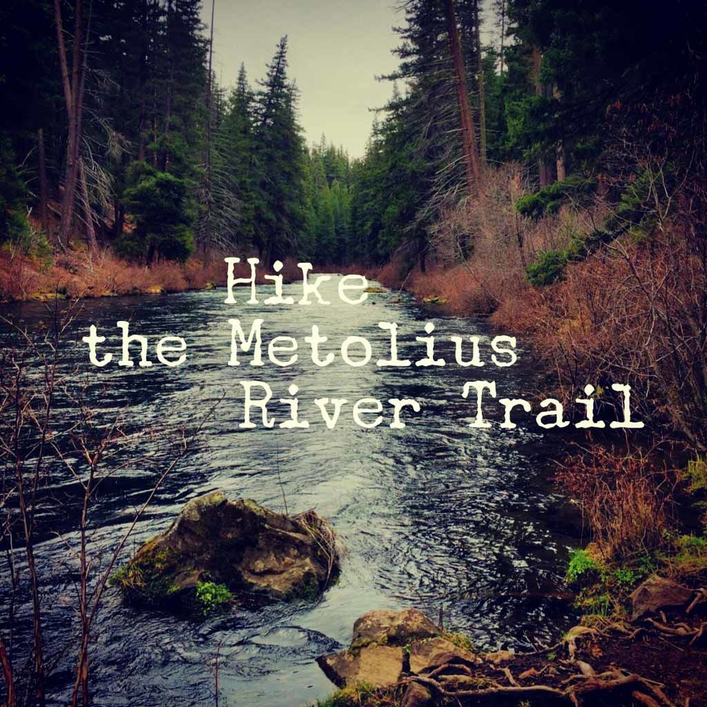
From the parking lot at Wizard Falls Fish Hatchery, face south and you’ll see the trailhead for the Metolius River Trail. This trail winds along the western bank of the Metolius, sometimes climbing  the hills where the incline is too steep; other times running right next the river’s edge.

Blue water of the Metolius River

One of the first and most striking features of the Metolius River is the brilliant blue water. It’s crystal clear with an iridescence that is captivating.

We hiked along the trail, sometimes tracking further inland and higher up the hills. The river is flanked by towering pine trees, and lush micro-landscapes along the way.

Mossy log

The real surprise of this out-and-back trail were the falls. These were our destination, and are astounding. Across the fast-moving Metolius springs a waterfall right out of the side of the mountain. There is no stream feeding it — it just appears and cascades into the the river.

Falls that spring from the side of the mountain

Geologists used to believe this water came from an underground spring at nearby Black Butte, but current thinking is that it actually follows underground lava tubes from miles away. Either way, it is remarkable to see a waterfall streaming from the side of a mountain.

Metolius River Trail Map

© OpenStreetMap contributors
Download

Photo Gallery

Click on any photo to view a larger version. You can also leave comments on any photo.

Hiker Trail along the Metolius River
One of several small bridges on the Metolius River Trail
Woodpecker workings
Metolius River Trail in Central Oregon
The Metolius River Trail
Mossy log
Blue water of the Metolius River
Moss-covered hollowed out log
Falls that spring from the side of the mountain


Metolius River Trail Tips

  • Spend some time exploring the fish hatchery. It’s pretty interesting in itself. Don’t miss the “escapee pond.”
  • Layer for unexpected changes in weather, and bring the ten essentials.

More Metolius River Resources

  • Wizard Falls Fish Hatchery – official website
  • GPS user? Download the GPX file (right-click and save as)
Book Recommendation
One of the hiking books that I really liked for the Bend area is Bend, Overall by Scott Cook. This book is written in a fun, casual style but has a lot of trails with some great details.

Highly recommended.

Metolius River Weather Forecast

The location could not be found.

Related

Filed Under: Trail Guides Tagged With: 3-6 miles, easy, family-friendly, Metolius, Oregon, out of bounds, river

Like what you found here at SoCal Hiker? This site is a labor of love. Share your support for the site and help us development of new trail guides and expanded coverage -- make your next outdoor equipment purchase through our advertisers.

You can also subscribe to our weekly newsletter and follow us on Facebook or Twitter.

Joan H

About Joan Hester

I've thru-hiked the John Muir Trail, summited more peaks than I can remember, and you'll find a photo of me somewhere in almost every trail guide on SoCalHiker.net. My trail name? Tortuga. Slow and steady...

Comments

  1. jbfox123 says

    September 16, 2014 at 4:46 pm

    I would love to know how you got the text box with the trip detail right in the middle of the page. So cool!

    Reply

Leave a Reply Cancel reply

Your email address will not be published. Required fields are marked *

This site uses Akismet to reduce spam. Learn how your comment data is processed.

About Jeff Hester

I created SoCal Hiker while preparing to thru-hike the John Muir Trail. My goal? Create guides for the best hiking trails throughout Southern California--and occasionally beyond. I personally hike each trail to create these guides, sharing practical advice on gear and outdoor skills. Read more...

Connect with SoCal Hiker

  • 22,109 Fans
  • 11,612 Followers
  • 21,640 Followers
  • 1,674 Followers
  • 5,420 Subscribers
  • 328 Subscribers

Get the SoCal Hiker Newsletter

Sign up to get your weekly trail recommendation and the latest updates from SoCal Hiker.

SoCalHiker was selected one of USA TODAY's 10 Best Hiking and Outdoor Blogs
Get our day-by-day guide to thru-hiking the John Muir Trail
Get up-to-day wildfire status throughout California

Products

  • Let your #SixPackOfPeaks flag fly Six-Pack of Peaks Camper Cap $23.00
  • Let your SoCalHiker flag fly! SoCalHiker Red, White & Blue Summit Flag
    Rated 5.00 out of 5
    $25.00
  • San Bernardino benchmark San Bernardino Peak Benchmark $39.95
  • Cucamonga Peak Benchmark Cucamonga Peak Benchmark $39.95

Sponsors

Sponsor SoCalHiker and see your banner here

Featured Posts

Hiking Camelback Mountain via the Echo Canyon Trail

Camelback Mountain is the most popular mountain to hike in the Phoenix area for good … [Read More...]

Hiking to High Point on Palomar Mountain in the Cleveland National Forest

Appropriately named High Point is the highest peak in the Palomar Ranger District of … [Read More...]

Hiking Hot Springs Mountain on the Los Coyotes Reservation

Hot Springs Mountain in the Los Coyotes Reservation is the highest peak in San Diego … [Read More...]

Lastest Comments

  • Ramesh on Haskell Canyon Open Space
  • Jeff H on Hiking the Tumalo Falls Loop
  • GGreco on Hiking the Tumalo Falls Loop
  • Allan Hoskins on Kintla Lake Hike in Glacier National Park
  • Elizabeth Dawson on Rae Lakes Loop via Kearsarge Pass
Get your SoCalHiker stickers now

Get your SoCalHiker stickers!

Latest Posts

  • Hiking Camelback Mountain via the Echo Canyon Trail December 9, 2020
  • Hiking to High Point on Palomar Mountain in the Cleveland National Forest December 4, 2020
  • Hiking Hot Springs Mountain on the Los Coyotes Reservation November 19, 2020
  • New Day Hiking Permit Requirements for Wilderness Areas in the San Bernardino National Forest August 31, 2020
  • Interview: John Soares, author of ‘Camp for Free: Dispersed Camping & Boondocking on America’s Public Lands’ July 30, 2020

Recent Forum Topics

  • 1st overnight backing trip
  • Recommendations for trips for me and my dog
  • log hikes
  • My Baldy
  • Cactus to Clouds v. Iron Mountain

The Six-Pack of Peaks Challenge Series

Six-Pack of Peaks Challenge SeriesThe Six-Pack of Peaks Challenge gives you an opportunity to explore your world while supporting a great cause.

Flex your adventure muscles!

Learn more here.


Search

Tags

3-6 miles 6-8 miles 8-10 miles 11+ miles Arizona Backpacking coastal dog-friendly easy family-friendly High Sierra Trail hiking Hiking The John Muir Trail hipster inspiration JMT John Muir John Muir Trail Kings Canyon National Park LA County moderate Mount Rainier National Park Muir Monday National Forest National Park Orange County Oregon out of bounds Pacific Crest Trail peak peakbagging quote scenic Sierra Nevada Six-Pack of Peaks State Park strenuous Thru-hiking Utah vista Washington waterfall wilderness Wonderland Trail Yosemite

Copyright © 2021 SoCalHiker.net · Metro Theme on Genesis Framework with WPEngine Hosting · Contact SoCal Hiker · Sitemap · Privacy Policy

Copyright © 2021 · Metro Pro Theme on Genesis Framework · WordPress · Log in