• COVID-19 Park and Trail Closures
  • Learn about the Six-Pack of Peaks Challenge
  • Shop
  •  

SoCal Hiker

  • Find a Hiking Trail
    • All Areas
    • Arizona
    • Colorado
    • Los Angeles
    • Orange County
    • Oregon
    • San Francisco Bay
    • Washington
  • Trail Guides
  • Six-Pack of Peaks
    • Colorado Six-Pack of Peaks
      • Bergen Peak
      • Rocky Mountain
      • Birthday Peak
      • Horseshoe Mountain
      • Grays Peak
    • New England Six-Pack of Peaks
    • NorCal Six-Pack of Peaks
      • Mount Umunhum
      • Mount Saint Helena
      • Mount Tamalpais
      • Mount Diablo
      • Mount Sizer
      • Rose Peak
    • Oregon Six-Pack of Peaks
      • Tumalo Mountain
      • Black Butte
      • Black Crater
      • Maiden Peak
      • Mount Bachelor
      • South Sister
    • SoCal Six-Pack of Peaks
      • Mt. Wilson
      • Cucamonga Peak
      • Mt. San Antonio (Mt Baldy)
      • San Bernardino Peak
      • San Jacinto Peak
      • San Gorgonio
  • Backpacking
    • High Sierra Trail
    • John Muir Trail
      • Overview of the John Muir Trail
      • Training
      • Day-by-Day Itinerary
      • Resupply Addresses
      • JMT Discussion Forum
    • Lost Coast Trail
    • North/South Lake Loop
    • Rae Lakes Loop
    • Red Peak Pass Loop
    • Theodore Solomons Trail
    • Trans-Catalina Trail
    • Wonderland Trail
  • Gear
  • Forums
    • Latest Topics
    • Ask a Question
    • Campfire
    • Trails
    • Trail Reports
    • Gear Wisdom
    • Classifieds
  • Login

Lake Hollywood Loop

May 3, 2013 By Jeff Hester 8 Comments

Can you see the Hollywood Sign

A walk along a serene lake, surrounded by pine trees and hills is probably not what springs to mind when you think of a “hike” in Hollywood. Surprise! The Lake Hollywood Reservoir trail is exactly that. Quiet. Serene. And a world apart from the scene on Hollywood Boulevard.

Trail Details
Distance: 3.4 miles
Time: 60-80 min.
Difficulty: Easy
Elevation gain: 50 ft
Dogs: No
When to go: Year-round
This 3.4 mile loop trail is mostly paved, and only recently reopened. Half of the loop was closed since 2005 while the hillsides and the paved trail below were repaired after landslides. In spring of 2013, the trail was completed and reopened to walkers, runners and bicyclists.

I like to walk in the evenings, and I’ve logged many miles in my neighborhood. But since this trail was just recently reopened, and it’s only six miles away, Joan and I decided to check it out. We weren’t disappointed.

Parking in LA is quite often an ordeal, usually involving daredevil maneuvering and some sort of payment–valet, meter or attendant. Often the neighborhood streets require permits to park, or are really crowded, especially around trailheads. Refreshingly, that was not the case here. There is ample, free street parking outside Gate 2.

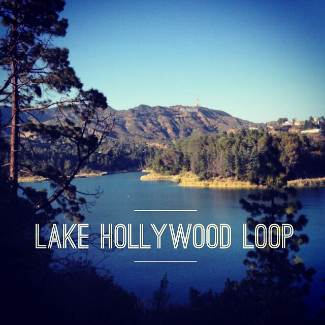
The trail itself is really a paved path that winds around the reservoir. The lake itself is used as a water supply for the city of Los Angeles, and so no swimming or fishing is allowed. In fact, a tall fence surrounds the entire lake. But it didn’t really spoil the views, as you can see. You’ll get spectacular, rare views of the Hollywood Sign with the lake in the foreground.

Not your typical Hollywood scene

What you notice first is that it’s really quiet. When you look at a map, you’ll see that the lake is pretty close to the 101 freeway. But it’s located in a valley, and the hills that separate it from the rest of the area provide a great sound barrier. It felt worlds away from what we drove through to get here.

You will have company. This trail is popular with walkers, hikers, joggers and bicyclists. It wasn’t so busy that it felt crowded, and everyone was friendly.

The next surprise was the wild life. We saw a baby rattlesnake on the trail (watch your step) and three deer grazing on the hill. They didn’t seem to mind sharing the peaceful scenery with us at all.

Deer!

The Mulholland Dam is an elegant structure that was built in 1924. Named after William Mulholland, the engineer responsible for design and construction of the California Aquaduct to Los Angeles. You walk directly across the top of the dam, then follow the paved road around the lake.

Mulholland Dam

Another view of the Mulholland Dam

The east side of the Hollywood Reservoir is partially a closed road, but then joins up with a public street. The final half mile you hike on a dirt trail adjacent to a public street with light residential traffic. This winds around the lake, following the contours until you return to the trailhead.

Lake Hollywood Loop Trail Map

Note that the elevation profile indicates lots of hills. This is incorrect. This trail is mostly flat, with negligible elevation gain or loss.

© OpenStreetMap contributors
Download

Photo Gallery

Click on any photo to view a larger version. You can also leave comments on any photo.

Gate 2
These gates are locked after hours
Rules and Regulations
No Dogs
Lake Hollywood
Another view of the Hollywood Reservoir
Deer!
Not your typical Hollywood scene
Baby Rattler
Can you see the Hollywood Sign
Mulholland Dam
Team J&J
Views of LA
Another Dam view
Mulholland Dam plaque
Lake Hollywood Panorama
Don't trespass
Closing times at Lake Hollywood
Another view of the Mulholland Dam
The back side of the loop
Looking west across the lake
Looking back towards the dam
Gateway fitting for Hollywood
The "trail"
Dirt trail parallels the road

Hollywood Reservoir Loop Tips

  • Dogs are not allowed, even on leash
  • Watch for rattlesnakes, especially in warmer weather
  • Pay attention to the closing hours. They vary by month, so make sure you allow enough time to get out before they lock the gates.
  • Hike, walk, jog, run or bike. Rinse and repeat.

More Lake Hollywood Trail Resources

  • Trailhead parking and driving directions via Google Maps
  • Hiking the Hollywood Reservoir – ModernHiker

Hollywood Weather Forecast

The location could not be found.

Related

Filed Under: Trail Guides Tagged With: 3-6 miles, easy, family-friendly, Hollywood, Hollywood Reservoir, Hollywood Sign, Hollywood Trails, Lake Hollywood, loop, Loop Trail

Like what you found here at SoCal Hiker? This site is a labor of love. Share your support for the site and help us development of new trail guides and expanded coverage -- make your next outdoor equipment purchase through our advertisers.

You can also subscribe to our weekly newsletter and follow us on Facebook or Twitter.

Jeff H

About Jeff Hester

I'm an avid hiker and backpacker. My wife Joan and I are on the trails every weekend. I started SoCal Hiker to share my passion for outdoor adventure.

Comments

  1. Josh says

    May 3, 2013 at 9:53 am

    Epic! I have been wanting to get out here but alas it is a much longer drive for me haha!

    Reply
    • Jeff HJeff Hester says

      May 3, 2013 at 1:30 pm

      Thanks, @Josh. This trail is practically in our backyard. I think we’ll be doing this on a regular basis on summer evenings after work.

      Reply
  2. Cliff says

    May 3, 2013 at 2:48 pm

    What a great post. Worked in Hollywood for years, but never made it up to the lake. I will definitely have to check it out.

    Reply
  3. Oscar Gonzalez says

    May 4, 2013 at 1:01 am

    You always find all these gems around Socal. Great stuff. I wonder, do you carry anything to help with a rattlesnake bite if it were to happen? I think I’ve seen other accounts where you ran into them.

    Reply
  4. nikkifrankhamilton says

    May 4, 2013 at 1:09 pm

    Once again, stunning photographs…feel like I am right there!

    Reply
  5. Hazel says

    May 6, 2013 at 3:02 pm

    Thanks for the links over on Twitter. Great site you have here. sent link to a few friends down there in Cali.

    Reply

Leave a Reply Cancel reply

Your email address will not be published. Required fields are marked *

This site uses Akismet to reduce spam. Learn how your comment data is processed.

About Jeff Hester

I created SoCal Hiker while preparing to thru-hike the John Muir Trail. My goal? Create guides for the best hiking trails throughout Southern California--and occasionally beyond. I personally hike each trail to create these guides, sharing practical advice on gear and outdoor skills. Read more...

Connect with SoCal Hiker

  • 22,109 Fans
  • 11,612 Followers
  • 21,640 Followers
  • 1,674 Followers
  • 5,420 Subscribers
  • 328 Subscribers

Get the SoCal Hiker Newsletter

Sign up to get your weekly trail recommendation and the latest updates from SoCal Hiker.

SoCalHiker was selected one of USA TODAY's 10 Best Hiking and Outdoor Blogs
Get our day-by-day guide to thru-hiking the John Muir Trail
Get up-to-day wildfire status throughout California

Products

  • Womens t-shirt with all the paths quote All the Paths Women's T-Shirt $26.50 – $28.00
  • Cucamonga Peak T-Shirt $23.00 – $27.50
  • Mt San Jacinto Benchmark $39.95
  • Mt Wilson Mug Mt Wilson Mug $15.95

Sponsors

Sponsor SoCalHiker and see your banner here

Featured Posts

Hiking Camelback Mountain via the Echo Canyon Trail

Camelback Mountain is the most popular mountain to hike in the Phoenix area for good … [Read More...]

Hiking to High Point on Palomar Mountain in the Cleveland National Forest

Appropriately named High Point is the highest peak in the Palomar Ranger District of … [Read More...]

Hiking Hot Springs Mountain on the Los Coyotes Reservation

Hot Springs Mountain in the Los Coyotes Reservation is the highest peak in San Diego … [Read More...]

Lastest Comments

  • Ramesh on Haskell Canyon Open Space
  • Jeff H on Hiking the Tumalo Falls Loop
  • GGreco on Hiking the Tumalo Falls Loop
  • Allan Hoskins on Kintla Lake Hike in Glacier National Park
  • Elizabeth Dawson on Rae Lakes Loop via Kearsarge Pass
Get your SoCalHiker stickers now

Get your SoCalHiker stickers!

Latest Posts

  • Hiking Camelback Mountain via the Echo Canyon Trail December 9, 2020
  • Hiking to High Point on Palomar Mountain in the Cleveland National Forest December 4, 2020
  • Hiking Hot Springs Mountain on the Los Coyotes Reservation November 19, 2020
  • New Day Hiking Permit Requirements for Wilderness Areas in the San Bernardino National Forest August 31, 2020
  • Interview: John Soares, author of ‘Camp for Free: Dispersed Camping & Boondocking on America’s Public Lands’ July 30, 2020

Recent Forum Topics

  • 1st overnight backing trip
  • Recommendations for trips for me and my dog
  • log hikes
  • My Baldy
  • Cactus to Clouds v. Iron Mountain

The Six-Pack of Peaks Challenge Series

Six-Pack of Peaks Challenge SeriesThe Six-Pack of Peaks Challenge gives you an opportunity to explore your world while supporting a great cause.

Flex your adventure muscles!

Learn more here.


Search

Tags

3-6 miles 6-8 miles 8-10 miles 11+ miles Arizona Backpacking coastal dog-friendly easy family-friendly High Sierra Trail hiking Hiking The John Muir Trail hipster inspiration JMT John Muir John Muir Trail Kings Canyon National Park LA County moderate Mount Rainier National Park Muir Monday National Forest National Park Orange County Oregon out of bounds Pacific Crest Trail peak peakbagging quote scenic Sierra Nevada Six-Pack of Peaks State Park strenuous Thru-hiking Utah vista Washington waterfall wilderness Wonderland Trail Yosemite

Copyright © 2021 SoCalHiker.net · Metro Theme on Genesis Framework with WPEngine Hosting · Contact SoCal Hiker · Sitemap · Privacy Policy

Copyright © 2021 · Metro Pro Theme on Genesis Framework · WordPress · Log in