• COVID-19 Park and Trail Closures
  • Learn about the Six-Pack of Peaks Challenge
  • Shop
  •  

SoCal Hiker

  • Find a Hiking Trail
    • All Areas
    • Arizona
    • Colorado
    • Los Angeles
    • Orange County
    • Oregon
    • San Francisco Bay
    • Washington
  • Trail Guides
  • Six-Pack of Peaks
    • Colorado Six-Pack of Peaks
      • Bergen Peak
      • Rocky Mountain
      • Birthday Peak
      • Horseshoe Mountain
      • Grays Peak
    • New England Six-Pack of Peaks
    • NorCal Six-Pack of Peaks
      • Mount Umunhum
      • Mount Saint Helena
      • Mount Tamalpais
      • Mount Diablo
      • Mount Sizer
      • Rose Peak
    • Oregon Six-Pack of Peaks
      • Tumalo Mountain
      • Black Butte
      • Black Crater
      • Maiden Peak
      • Mount Bachelor
      • South Sister
    • SoCal Six-Pack of Peaks
      • Mt. Wilson
      • Cucamonga Peak
      • Mt. San Antonio (Mt Baldy)
      • San Bernardino Peak
      • San Jacinto Peak
      • San Gorgonio
  • Backpacking
    • High Sierra Trail
    • John Muir Trail
      • Overview of the John Muir Trail
      • Training
      • Day-by-Day Itinerary
      • Resupply Addresses
      • JMT Discussion Forum
    • Lost Coast Trail
    • North/South Lake Loop
    • Rae Lakes Loop
    • Red Peak Pass Loop
    • Theodore Solomons Trail
    • Trans-Catalina Trail
    • Wonderland Trail
  • Gear
  • Forums
    • Latest Topics
    • Ask a Question
    • Campfire
    • Trails
    • Trail Reports
    • Gear Wisdom
    • Classifieds
  • Login

Hiking Angels Landing

August 29, 2014 By Jeff H 6 Comments

Hiking to Angels Landing

We ascended Walter’s Wiggles, the 21-switchbacks carefully engineered and reinforced with sandstone blocks and were standing atop Scout Lookout, with awe-inspiring views down into Zion Canyon and over the Virgin River. Looming before us was a slender finger of red sandstone leading to Angels Landing. I have been up Half Dome several times. I’ve sat atop Banner Peak and dangled my feet over Thousand Island Lake. And I’ve climbed to the top of Mt Whitney in the darkness of night. But looking at the “trail” before us I got butterflies. At first glance, the trail up to Angels Landing looks impossibly steep and treacherous.

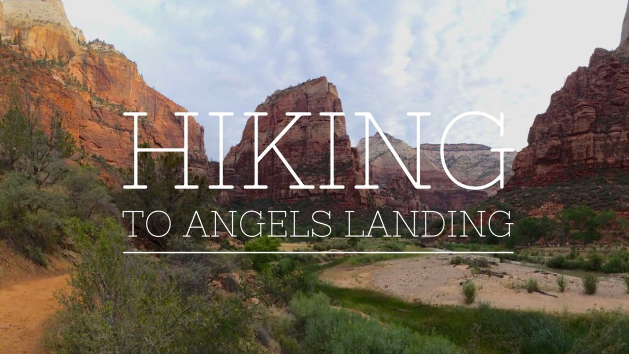
Angels Landing in Zion National Park is one of the most challenging and rewarding hikes in the park. The slender spine of red sandstone juts into the canyon like a spine, and provides epic views in all directions. Getting to the top requires you to check your acrophobia at the trailhead, and the final push from Scout Landing has sheer drops with little room for errors.

img
Trail Details
Distance: 5 miles
Time: 4 hours
Difficulty: Strenuous
Elevation gain: 1,500 ft
Dogs: No
When to go: Year-round
On our Utah road trip to the Summer ORShow in Salt Lake City we made plans to stop in Zion National Park. Originally, we were going to hike the Narrows, another great trail that takes you right into the Virgin River through narrow canyons. The threat of thunderstorms and the flash flood watch made us go with Plan B — hike to Angels Landing.

We arrived at Zion National Park early in the morning, and got parking at the visitor center parking lot near the entrance. During the summer months, Zion does not allow cars in the canyon. Instead, you park at the visitor center or in neighboring Springdale and take a shuttle into the valley.

Angels Landing Trail Description

We took the shuttle to the Grotto Trailhead — the sixth stop in Zion’s main canyon. There are restrooms and picnic tables near the shuttle stop. We checked our water and headed over the bridge across the Virgin River and up the West Rim Trail.

Bridge at the Grotto Trailhead

The trail is actually paved as it slogs uphill winding close to the canyon wall.

Looking Down Refrigerator Canyon

At 1.5 miles you reach beautiful Refrigerator Canyon.

Refrigerator Canyon Wall
Hiking Down Refrigerator Canyon

This deep, narrow side canyon is shady and stays cool even in the summer. This section climbs more gently, giving you a bit of a breather until you reach Walter’s Wiggles.

Looking down Walter's Wiggles

These 21 switchbacks are steep and short, and an amazing bit of 1930’s trail engineering. Our legs felt good, but the climb really gets your heart pumping.

At the top of the wiggles we reached Scout Landing. Many people reach this point and go no further, intimidated by the path ahead that seems more like a trial than a trail. This is a good spot to take a break, eat a snack, drink some water and consider… are your papers in order?

Shadows on Refrigerator Canyon
The trail goes UP this spine
Zion Canyon

The sign to Angels Landing declares ominously: “Since 2004, six people have died falling from the cliffs on this route. The 1.1 mile round-trip from Scout Landing to Angels Landing is a strenuous climb on a narrow ridge over 1,400 feet above the canyon floor. This route is not recommended during high winds, storms or if snow or ice is present.” 

img
Warning
People have fallen to their death on this trail. It is exposed and can be brutally hot in the summer, or icy and slippery in the winter. Do not attempt if raining, snowing or freezing, as this amplifies the dangers. As the signs at the trailhead warn, “your safety is your responsibility.” 

I was determined to go to the top. Many people do every day. I wasn’t sure if Joan would be as enthusiastic. But when I saw the narrow spine that we would be climbing to reach Angels Landing, I felt my pulse quicken. A little voice in my head said “Really? No way!”

We caught our breath and decided to give it a go. 

The Angels Landing trail traverses solid sandstone with sheer drops of hundreds of feet possible. People have died on this trail, as the signs warn. In most places, the trail involves following a well-worn route over the steep sandstone while holding a chain on one side. And it’s not that bad. With proper shoes, a decent sense of balance and a rational fear of death (keeping you from behaving foolishly), you can hike this trail. You will gain another 500 vertical feet in a very short distance, but take your time. Breathe.

Yes This Is The Trail
Go Up This
Looking Down Angels Landing Trail
View from Scouts Landing

Reaching the top is exhilarating, and the views are magnificent.

View from Angels Landing

Angels Landing plenty of area to spread out and enjoy the views. We took time to soak it all in and recorded a short time-lapse video of the view down the canyon.

Heading down was complicated. When we got to Angels Landing, it was early enough in the morning that not many people were coming down yet. As we descended, there was a steady stream of hikers making their way up the narrow spine. With only one chain, passing is best done with extreme caution.

Once we were back at Scout Landing, the rest of the hike down was easy.

Angels Landing Trail Map

© OpenStreetMap contributors
Download file: angels-landing.gpx

Angels Landing Photo Gallery

Click on any photo to view a larger version. You can also leave comments on any photo.

Refrigerator Canyon
Looking Back Down
Joan on the Edge of Angels Landing
Jeff on the Edge of Angels Landing
Heading Back Down the West Rim Trail
Back at the Trailhead
Angels Landing From the Valley Floor

Angels Landing Tips

  • Start early. Not only will you find fewer people, you’ll also have cooler temperatures — and important consideration in the summer.
  • Take plenty of water. This is not a trail where you want to skimp on water. Bring 1-2 liters and stay hydrated.
  • This trail has a lot of sun exposure. Use sun protection and a hat.
  • Don’t take unnecessary risks. Be aware of the people around you. One accidental bump could be tragic.

More Zion National Park Resources

  • Zion National Park website
  • Lunch at the Lodge — but upstairs (on the patio if the weather permits). It is quieter and much more relaxed.

Zion National Park Weather Forecast

The location could not be found.

Filed Under: Trail Guides Tagged With: 3-6 miles, National Park, out of bounds, scenic, strenuous, Utah, vista, Zion National Park

Like what you found here at SoCal Hiker? This site is a labor of love. Share your support for the site and help us development of new trail guides and expanded coverage -- make your next outdoor equipment purchase through our advertisers.

You can also subscribe to our weekly newsletter and follow us on Facebook or Twitter.

Jeff H

About Jeff H

I'm an avid hiker and backpacker. My wife Joan and I are on the trails every weekend. I started SoCal Hiker to share my passion for outdoor adventure.

Comments

  1. Carman Cheung says

    August 30, 2014 at 10:05 pm

    Fantastic photos! We did this a couple years back and it was one of my favorites. Took first bus to trail head and caught sunrise thru the valley… Looking at your photos makes me wanna revisit zion again! Thanks for sharing!

    Reply
  2. Marla Meckes (@MarlaHikes) says

    September 8, 2014 at 10:48 am

    Did this hike a couple of years ago, but…I didn’t make it all the way to Angels Landing. I started up, then realized that going up was the (comparatively) easy part. I always have trouble getting down from steep areas, and I just knew I couldn’t do it. So I waited at Scout Overlook with my sis-in-law while my brother and 10 year old nephew did the climb. Even though I didn’t make it to the top, it’s still one of my favorite hikes. The views from Scout Overlook were amazing! Thanks for sharing your experience and beautiful photos!

    Reply
  3. scottysbeard says

    September 14, 2015 at 10:49 am

    Looks great, I want to go to Zion on my next road trip. Returned from a trip to the Grand Canyon last night, took the Bright Angel Trail down to Indian Garden and my legs are absolutely done. The trip down was relatively easy and I had not exerted so much effort that I thought I was in any danger, but as soon as I started the hike back up to the 3 mile rest house I realized that I wasn’t going to be able to power through this with the strength and vigor I had in my 20’s. I had carried along two quart sized water bottles and utilized the water taps at the rest houses along the trail (a dangerous crutch to rely on as I’m told the pipes occasionally fail due to erosion or other factors), without the gallons of water I ended up drinking I would have collapsed from dehydration. I had forgotten my hiking boots in a rush to get on the road so I went down the trail in a worn out pair of Nike running shoes with holes near the toe, I had on a baseball cap that did not do much to protect my neck from what turned out to be 10 hours of exposure, and I chuckled inwardly at the people with trekking poles on the way down not realizing the toll that an uneven path will take on your body when you’re constantly trying to stabilize yourself. The warning about you had written here about safety and responsibility went through my head at this point, I knew that only I could get myself out of the Canyon and my lack of respect for nature and the warnings of many that had gone before me is what brought me to that point. I made it out after 6 hours of intermittent climbing and resting, 4.7 miles seems like an endless expanse when you’re in the canyon because when you’re inside you often only see the top of the nearest ridge and not the rim you’re trying to reach. When I reached the trail head I vowed never to attempt a hike I was not prepared for again, I’m planning to return in a year or two at a much lower weight and in better shape for an overnight Rim to Rim hike, part of my planned training regimen is your 6 Peaks Challenge. I enjoy your blog immensely and look forward to the day you tackle the canyon, having gone in ill-prepared I’d like to hear your perspective on what it’s like when done properly.

    Reply
  4. Julie says

    August 11, 2017 at 6:45 am

    What time did you start the hike? My fiancé and I are planning to go next Saturday, August 19th. Thanks!

    Reply
    • Jeff HJeff Hester says

      August 11, 2017 at 7:51 am

      Hi Julie! We started at 8:30am on August 4th.

      Reply
  5. reaction bonded silicon carbide says

    October 19, 2017 at 4:49 pm

    It’s a pity you don’t have a donate button! I’d definitely donate to this superb blog!
    I suppose for now i’ll settle for book-marking and adding your
    RSS feed to my Google account. I look forward to brand new
    updates and will share this website with my Facebook group.

    Chat soon!

    Reply

Leave a Reply Cancel reply

Your email address will not be published. Required fields are marked *

This site uses Akismet to reduce spam. Learn how your comment data is processed.

About SoCal Hiker

Jeff on Mount Rainier

I created SoCal Hiker while preparing to thru-hike the John Muir Trail. My goal? Create guides for the best hiking and backpacking trails with enough detail to make it an enjoyable experience for you. And while I started with trails in Southern California, I’ve expanded across the west. We hike each trail to create these guides, sharing practical advice on gear and outdoor skills. Read more…

Connect with SoCal Hiker

  • 22,757 Fans
  • 11,938 Followers
  • Followers
  • 1,719 Followers
  • 5,281 Subscribers
  • 341 Subscribers
SoCalHiker was selected one of USA TODAY's 10 Best Hiking and Outdoor Blogs
Get our day-by-day guide to thru-hiking the John Muir Trail
Get up-to-day wildfire status throughout California

Products

  • Half Dome replica benchmark Half Dome Benchmark $39.95
  • Cucamonga Peak T-Shirt $23.00 – $27.50
  • Mt San Jacinto Benchmark $39.95
  • Mt San Gorgonio Mug San Gorgonio Mug $15.95

Sponsors

Sponsor SoCalHiker and see your banner here

Featured Posts

Backpacking the Grand Canyon of Tuolumne Loop in Yosemite National Park

Yosemite National P ark, and in particular Yosemite Valley, is home to some of the … [Read More...]

Hiking Belknap Crater in the Mountain Washington Wilderness

Hiking this out-and-back route up Belknap Crater you'll traverse an other-worldly … [Read More...]

Hiking to the Simpson Reef Overlook on the Oregon Coast Trail

The Oregon Coast is rugged, beautiful and often uncrowded. This bluff-top … [Read More...]

Lastest Comments

  • Amy Courtney on Ridgeline Trail
  • Jay Eleanor on Hiking to the Simpson Reef Overlook on the Oregon Coast Trail
  • Charles Krim on Hiking to the Simpson Reef Overlook on the Oregon Coast Trail
  • 11 Best California Bikepacking Routes | Wild Lumens on Inside Crystal Cove State Park
  • Ted Thed on Burbank Peak, Cahuenga Peak, Mt. Lee and the Hollywood Sign
Get your SoCalHiker stickers now

Get your SoCalHiker stickers!

Latest Posts

  • Backpacking the Grand Canyon of Tuolumne Loop in Yosemite National Park March 24, 2023
  • Hiking Belknap Crater in the Mountain Washington Wilderness October 20, 2022
  • Hiking to the Simpson Reef Overlook on the Oregon Coast Trail August 25, 2022
  • Join Team SoCalHiker at the Climb for Heroes August 23, 2022
  • Hiking the Welch-Dickey Loop in the White Mountain National Forest August 18, 2022

Recent Forum Topics

  • Lost Coast Trail
  • How to deal with accidents while hiking in the winter?
  • Warm Tips for your hiking in winter
  • Some tips for hiking.
  • Keep your body warm in the winter hiking

The Six-Pack of Peaks Challenge Series

Six-Pack of Peaks Challenge SeriesThe Six-Pack of Peaks Challenge Series gives you an opportunity to explore your world while supporting a great cause. There are eleven challenges around the country. Hike or run them at your own schedule.

Flex your adventure muscles!

Learn more here.


Search

Tags

3-6 miles 6-8 miles 8-10 miles 11+ miles Arizona Backpacking coastal dog-friendly easy family-friendly High Sierra Trail hiking Hiking The John Muir Trail hipster inspiration JMT John Muir John Muir Trail Kings Canyon National Park LA County moderate Mount Rainier National Park Muir Monday National Park Orange County Oregon out of bounds Pacific Crest Trail peak peakbagging quote scenic Sequoia National Park Sierra Nevada Six-Pack of Peaks State Park strenuous Thru-hiking Utah vista Washington waterfall wilderness Wonderland Trail Yosemite

Copyright © 2023 SoCalHiker.net · Metro Theme on Genesis Framework with WPEngine Hosting · Contact SoCal Hiker · Sitemap · Privacy Policy


Loading Comments...