


Elevation gain: 46,700 ft.
Mountain passes: 7
High point: 14,505 ft.
When to go: July – Sept.
The primary hiking season is July – September, and an overwhelming majority hike from north to south, allowing a more gradual acclimatization to the higher altitude.
Hiking the JMT requires considerable planning and training. Most thru-hikers cover the distance in about three weeks or longer. Though the trail does not cross any roads, there are several resupply points near the trail. And the fact that the southern terminus is the top of Mt. Whitney means you need to add at least 11 more miles to reach the nearest trailhead (Whitney Portal).
Permits are required for hiking the John Muir Trail, and assuming you start at the north end, they need to be requested exactly six months prior to your start date. Currently the best practice is to fax your permit application to the ranger station at Yosemite National Park before 7am exactly 26 weeks before your requested start date. Getting the entry trailhead and date you want can require a bit of luck and persistence. My initial request was denied (including two alternatives), but I tried again the next day and got my first choice.
If you feel lucky, or don’t mind staying up all night, 40% of the permits are reserved for walk-ins on the day of departure on a first-come, first-serve basis. I’ve heard that the line forms about 9pm the night beforehand, and the ranger station opens at 7am. Not my choice, but it may be yours.
What to Expect on the JMT
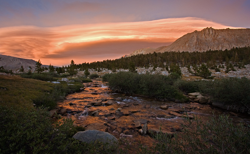
Prepare to be amazed. The John Muir Trail covers some of the most beautiful mountains in the world, from stunning, glacier-chiseled Yosemite, to the jagged spires of the Minarets, to the highest mountain peak in the contiguous United States. You’ll hike over numerous high mountain passes, pass ancient glaciers, cross fast-moving mountain streams while surrounded by giant peaks.
The JMT is truly a wilderness trail, coming close to civilization at only a few points. Being out on the trail with only your skill, your equipment and your wit to survive will sharpen your perspective on life.
At the same time, you’re not ever really alone. Many people travel the trail, or a portion of it, every year. While you may go all day without seeing a soul, stop for a while and you soon find there are others making the trek.

I first hiked the John Muir Trail in 1980. I had just graduated from high school, and had planned the trip with some fellow backpackers. Our group ranged in age from 13-50, and we completed the hike over 25 days in August. It was a memorable trip.
This August, almost 30 years later to the day, I’ll be back on the JMT.
Resources to Inspire
If you’re interested in hiking the John Muir Trail, there are a several great resources I’d like to share. They can help inspire you to start planning your own epic backpacking trip.
Ron Pepper’s John Muir Trail web site provides an excellent overview of the trail and what it takes to hike it. His site is devoted exclusively to the JMT and has extensive resources and links that will make preparation much easier.
To connect with other JMT hikers, check out the John Muir Trail group on Yahoo. This is a very active community with many members who have hiked the JMT multiple times. It’s a place to ask questions about the JMT, preparing, planning, equipment or even finding partners to hike with.
There are three JMT guidebooks that I highly recommend:
- John Muir Trail: The essential guide to hiking America’s most famous trail – Wilderness Press
This is the latest edition of the book originally written by Thomas Winnett — the same one I used on my first JMT trek in 1980. It’s double the size of that version, and therefore better suited for the bookshelf at home rather than on the trail. Still, an invaluable planning resource. - The John Muir Trail Through the Californian Sierra Nevada – Cicerone Guide
I prefer this guide to the WP one. It’s compact and concise. It’s written by Englishman Alan Castle, but in some ways, that makes it better suited for the complete first-timer. You just have to get used to calling your flashlight a “torch.” - Blackwoods Press John Muir Trail Atlas
This begins shipping in June 2010, and it’s pricey ($35). But with full color, well-annotated maps, I’m really looking forward to this one. I’ve got a copy on order and will give you my final analysis once I get it.
Apart from these, you also want to get the Tom Harrison JMT map pack. It comes with 13 8.5″ x 11″ shaded relief topo map pages that cover the entire JMT and surrounding areas.
Photos from the John Muir Trail
Just a small taste of the sights on the trail to whet your appetite. If you’ve got JMT photos to share, leave a link in a comment.


