
DAY FOUR on the North Lake/South Lake Loop
We woke early and it was cold at Sapphire Lake. There was ice all over the outside of the rain fly and it took a few minutes for me to warm my clothes inside my sleeping bag before I wanted to put them on.
Time: 6-9 hours
Difficulty: Strenuous
Gain/Loss: +936’/-3,104′
Dogs: No
When to go: Late July-Early October
The gentle 500 vertical foot ascent to Wanda Lake was beautiful – the only thing slowing us down was a long wet crossing where we had to change shoes just below Wanda Lake.

At 11,426 feet in elevation, Wanda Lake is high and massive! And, coming off this big winter made it even more so! The peaks surrounding Wanda Lake were still spotted with snow, and the trail at the east end of the lake heading up past Lake McDermand to Muir Pass had several nice snow fields to cross, although the sun cups weren’t as big and high as they probably were a month earlier.

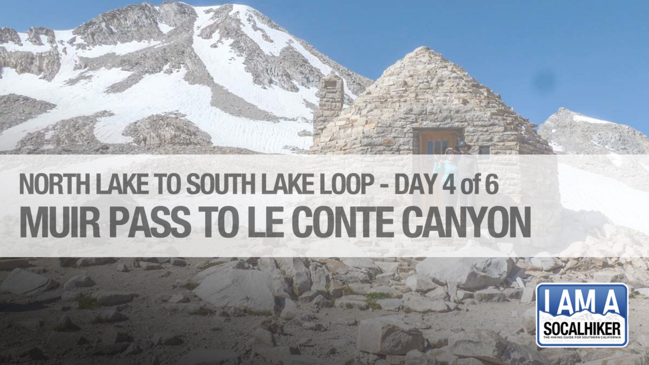
The anticipation of seeing Muir Hut for the first time doesn’t drag on – you can see it from a long ways a way as you slowly ascend from Wanda Lake. It’s pretty cool to see it that far away and have it as an ascent target as you slowly make your way up the bowl and across the snow.
And just like that, there we were!! Muir Hut at 11,955 feet! Mountain pass #2 accomplished! There were about 8 to 10 other people hanging out at the hut, and we got a nice girl to take our picture together. We checked out the inside of the hut – and you would definitely appreciate having it if you got stuck on the pass in bad weather.

After a snack and some photos, we decided to chat with a few other folks as they got set to head down the east side towards Helen Lake. There was a pretty large snow field and we wanted to make sure that we checked for the safest way down. There was a good set of footprints well to the right of the main trail, and that appeared to be the snow path that everyone was taking.
The descent was pretty steep, but slushy enough to make microspikes not particularly helpful. My wife put hers on – and it seemed to give her some good confidence. We slowly made our way down the steep snowfield until it married up with the trail at the bottom after a bit of boulder hopping. It was nice to get that out of the way!
The trail down to and past Helen Lake would be off and on snow fields and some partial route finding. We used our GPS and kept our eyes open and slowly and safely made our way down and around. We also encountered several wet crossings – some of which could be avoided with some bouldering, but for us it was easier just to put on the Tevas and plow right through.


A dozen or so hikers were coming up the other way, and we were glad to share our beta on the snow fields and Muir Pass. As they were all going up, they would certainly have no problems with the snow. As we continued down the trail, there were some amazing shots of the runoff melting away the snow – areas that were snow bridges and snow crossings a few weeks ago were now washing away fast.

Eventually we hit the tree line and started the long winding descent down into the gorgeous Le Conte Canyon. It is really quite a spectacular and beautiful canyon, surrounded by majestic and jagged Sierra peaks on both sides. Incredible waterfalls and water features – along with a few more wet crossings – followed us all the way down.
The first campsite at the north end of Le Conte Canyon features the famous Monster Rock – and so of course I had to take the obligatory photo in the mouth of the beast!

The next campground is Big Pete Meadow – but a group of backpackers had beat us to it, so we kept going in hopes that Little Pete Meadow would be empty. Minutes later, we arrived at Little Pete – and it was all ours! It was a great campsite with a great water source, a fire ring, and another family of deer to keep us company.

Little Pete is also just a short hike from the Le Conte Canyon Ranger station and the Dusy Basin / Bishop Pass trail junction – so again we had positioned ourselves perfectly for a morning ascent the next day up to Dusy Basin.
Our friends Mark and Brian arrived not long after us – and we shared a fire and dinner. They were looking pretty beat up, and weren’t sure if they wanted to keep going all the way to Kearsarge and then Whitney. We invited them to go out with us at Bishop Pass and they happily agreed. Eleven days would be enough for them on their first backpacking adventure – and we were glad that we could help them exit safely and give them a ride back to Bishop.
Sapphire Lake to Little Pete Meadow Trail Map & Elevation Profile
Originally hiked on Wednesday, August 23, 2017.
Continue to Day Five: Little Pete Meadow to Upper Dusy Basin

You must be logged in to post a comment.